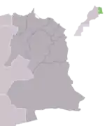
Berkane
Berkane or (Arabic: بركان, Amazigh: ⴰⴱⴻⵔⴽⴰⵏ ) is a city in northeastern Morocco, in the area of Trifa, limited by the Mediterranean to its north, the Kiss Oued (Moroccan-Algerian border) and Oujda Province in the east, Nador Province to the west, and Taourirt Province in the south. It is the capital of Berkane Province.
Berkane
بركان / ⴰⴱⴻⵔⴽⴰⵏ | |
|---|---|
City | |
   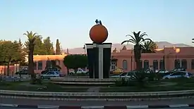 The clementine, sculpture in the city centre of Berkane | |
| Nickname(s): Orange city | |
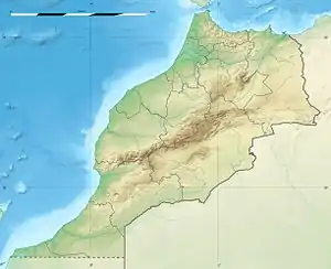 Berkane Location in Morocco 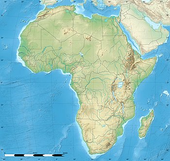 Berkane Berkane (Africa) | |
| Coordinates: 34°55′N 2°19′W | |
| Country | |
| Region | Oriental |
| Province | Berkane |
| Population (2014)[1] | |
| • Total | 109,237 |
| Time zone | UTC+1 (WET) |
| Postal code | 63300 |
Population
The city recorded a population of 109,237 in the 2014 Moroccan census.[1] The inhabitants of Berkane originate primarily from Yat Iznasen, a major tribe which consists of Berber clans. The tribe's descendants are also spread over the rest of eastern Morocco, in cities like Ahfir, Saïdia and Oujda. The eastern dialect of Moroccan Arabic is spoken by most of the citizens, although Amazigh is still spoken by many of the adults.
According to the last official census, the population of the Berkane region will reach a total of 289,137 people, that is, an estimated 12.5 percent of the population of the eastern region, with a high density of 145.7 people per square kilometer compared to 25.7 people per square kilometer in relation to the region. With a high urbanization rate of 63.2 percent.
Historic population
As the population moved from 368 people in 1917 to 3,600 people in 1936 and then doubled in 1947, it reached 7,545 people, then it jumped to 20,496 people in 1960, then to 60,490 people in 1982 and 77,026 in 1994. In the year 1996, the city's population was estimated at 82,000 people.
Etymology
The city takes its name from the saint Sidi Ahmad Aberkane (who died in 868 of the Islamic calendar). The name of the city (Berkan > aberkan) means "black colour" in the Amazigh language.
Recent city
The city of Berkane is considered a agricultural city as a result of the irrigation policy that colonialism followed, starting in the middle of the first half of the twentieth century, in the major irrigated circles. Especially since it is located on one of the richest plains in Morocco, the Tarifa plain.
The emergence of Berkane as a city and its development was linked to the local agricultural wealth. But the administrative leadership of the fledgling city, which abolished the old political entities, whom are Bani Yaznasan tribes, was behind the French political decision in the colonial period to assign the role of direct leadership to Aberkane over the neighboring tribes instead of the decentralized leadership of the Oujda prefecture. The development of the agricultural economy and the improvement of the standard of living in this city have contributed to emptying the tribes from their population and displacing the human weight from the mountain fortress to the open plain. What facilitated the process of military control of the French occupation of the region. The massive influx of workers in the agriculture sector from different Moroccan regions has also disrupted the homogeneous tribal fabric. The area is drowned in a new flood.
Economy
Berkane is considered the capital of the citrus fruit industry of Morocco, and high-quality fresh fruit and vegetables are plentiful year round. It is known for its farms of clementines. Also a large statue of an orange is at the center of town. It is very close to Saïdia, a popular beach resort town on the Mediterranean, as well as Tafoughalt, a small village in the nearby mountains known for its healthy air and herb markets.
Berkane is a commercial and business strip, Ibn Sina/Rue Dehb or Alhob (meaning "The Street of Gold and or street of love"), which is lined with many of the most popular cafes and jewelry shops. The city sprawls into the hillsides and connects via bridge to a small neighboring town Sidi Slimane, giving the impression that it is much larger than the census claims.
Notable people
- Hicham El Guerrouj, Olympic athlete, world record holder for the fastest mile
Twin towns – sister cities
 Bondy, France
- Perpignan, France
.svg.png.webp) Saint-Gilles, Belgium
Saint-Gilles, Belgium Zeist, Netherlands
References
- "POPULATION LÉGALE DES RÉGIONS, PROVINCES, PRÉFECTURES, MUNICIPALITÉS, ARRONDISSEMENTS ET COMMUNES DU ROYAUME D'APRÈS LES RÉSULTATS DU RGPH 2014" (in Arabic and French). High Commission for Planning, Morocco. 8 April 2015. Retrieved 29 September 2017.
- "L'intégration régionaleet locale du volet migration et développement au Maroc" (PDF). oriental.ma (in French). Initiative Conjointe pour la Migration et le Développement. 2013. p. 86. Retrieved 2020-12-02.
External links
![]() Media related to Berkane at Wikimedia Commons
Media related to Berkane at Wikimedia Commons
- Nador Rif News شبكة أخبار الناظور و الريف أريفينو.نت ; www.ariffino.net
- Berkane entry in lexicorient
- Berkane Fort Web Site