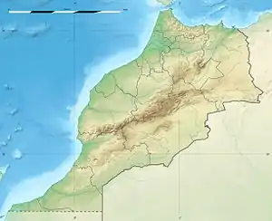
Nador
Nador (Berber: Ennaḍor, ⴻⵏⵏⴰⴹⵓⵔ; Arabic: الناظور or الناضور) is a coastal city and provincial capital in the northeastern Rif region of Morocco with a population of about 161,726 (2014 census).[1]
Nador / Ennaḍor
Ennaḍor / ⴻⵏⵏⴰⴹⵓⵔ الناظور / الناضور | |
|---|---|
   .jpg.webp) | |
 Nador / Ennaḍor Location in Morocco 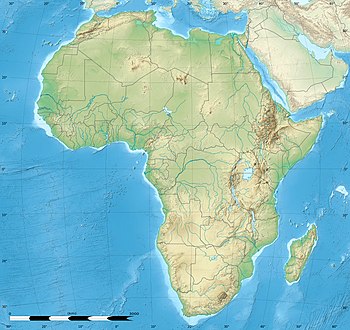 Nador / Ennaḍor Nador / Ennaḍor (Africa) | |
| Coordinates: 35°10′0″N 02°56′0″W | |
| Country | |
| Region | Oriental |
| Province | Nador |
| Government | |
| Elevation | 42 m (138 ft) |
| Population (2014)[1] | |
| • Total | 161,726 |
| • Rank | 19th in Morocco |
| • Ethnicities | Berbers: 98%; Spaniards: 1%; Other foreigners: 1% |
| Time zone | UTC+1 (CET) |
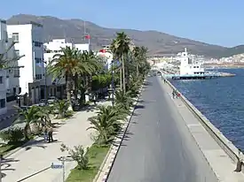
Nador city is separated from the Mediterranean Sea by a salt lagoon named Bḥar Ameẓẓyan in Berber (Mar Chica in Spanish) and is 10 kilometres (6.2 mi) south of the Spanish city of Melilla.
Nador was founded in the 19th century by local Berber tribes and the Azzouzi [2]and was under Spanish occupation from 1912 until Morocco's independence in 1956.[3]
The Nador Province has over 600,000 inhabitants, predominantly of Rif-Berber ethnicity. Nador is considered the second largest city in the Oriental East after Wejda.
Etymology
The origin of the city name is disputed. It may have originated from Has Nador, which was a small village by the lagoon, or it may have come from the Arabic term meaning either lighthouse[4] or sight.[3]
Overview
The economy of Nador and Nador province includes fishery, agriculture, some light and heavy industry.[5]
In the summer months of June to August thousands of people originating from the Nador area and living in Europe return to the city. The total of these annual visitors may exceed 250,000. They mainly stay with relatives or in rented or owned apartments, rather than staying in Nador's hotels.
The location of the city on the Mediterranean coast and proximity of the Spanish town Melilla mean there is significant international trade, particularly evident in the widespread sale of Spanish manufactured foodstuffs and household goods in Nador.
Nador was infamous as a centre of smuggling cheap Spanish and Chinese duty-free goods. Currently the smuggling has declined but it still alive competing with a smuggling stream from Algeria. Many used consumer goods from Europe and China find their way to Morocco and Africa via Melilla and Nador, both legally and illegally. The goods range from conserved food, clothes, shoes, electric home appliances, up to sophisticated hardware.[6]
Demographics
It has recently become a fast-growing city,[7] despite experiencing a population drop with the departure of the Spanish, when the population decreased from 23,000 in the early 1950s[8] to less than 5,000 in 1960. Nador's population grew by 566% between 1960 and 1971, from 4,806 people in 1960 and 32,000 in 1971.[9] Its population has since grown with over 500% once again, to a total estimated population of 200,000 in 2015.[10] Only eight years previously, in 2007, the city had a population of 120,000.[11] 98 percent of the city-population is made up by Riffian-Berbers. The Amazigh culture is dominant and Nador is the largest Tarifit-speaking (one of the Tamazight languages) city in the world.[12] The population density in the city of Nador is many times that of the larger Nador Province.[13]
Geography
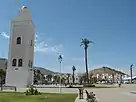
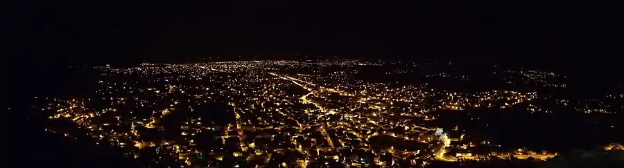
Nador is the 19th largest city in Morocco and is the capital of Nador Province in the Oriental Region of northern Morocco. It is located on the Sebkha Bou Areq lagoon on the Mediterranean coastline. The city sprawls along the coast. It is approximately 75 km (47 mi) west of the Algerian border, 10 km (6.2 mi) south of the Spanish enclave of Melilla, and 380 km (240 mi) east of the Moroccan capital of Rabat. The city center of Nador is largely a grid of streets around the north-south axis of Avenue Hassan II, with the main bus- and taxi stations at its southern end. Avenue Mohammed V runs from the city's waterfront to the city's governmental facilities and town hall on its east end.[14][15] Mohammed V Boulevard has open plazas and Spanish Iberian-style architecture, particularly seen in the Roman Catholic churches.[16] The administrative city center, main post office, and the Grand Mosque are all located on the Youssef Ben Tachfine Boulevard.[17]
Nature
The salt lagoon off and to the east of the city attract wildlife, especially migratory birds [18][19] The protected wetlands at Oued Moulouya and Kariat Arekman by the Moulouya River mouth are home to greater pink flamingos, great crested grebes, avocets,[20] black-winged stilts, coots, dunlins, oystercatchers, Audouin's gulls, grey herons, little egrets, spotted redshanks, black-tailed godwits, common redshanks, kingfishers, black terns, and numerous other species of terns and gulls.[3][21] As well as being a safe haven for birds, this area is frequently visited by locals because of its natural environment. There are major freshwater and saline sites covering large areas of protected sand dunes, marsh- and swampland. Insects include damselflies, Caelifera, and numerous others. The flora includes marram grass, juniper, Cistus, and more.[3]
Climate
Nador has a hot semi-arid climate (Köppen climate classification BSh). In winter there is more rainfall than in summer. The average annual temperature in Nador is 18.7 °C (65.7 °F). About 313 mm (12.32 in) of precipitation falls annually.
| Climate data for Nador | |||||||||||||
|---|---|---|---|---|---|---|---|---|---|---|---|---|---|
| Month | Jan | Feb | Mar | Apr | May | Jun | Jul | Aug | Sep | Oct | Nov | Dec | Year |
| Average high °C (°F) | 16.6 (61.9) |
17.2 (63.0) |
18.9 (66.0) |
20.8 (69.4) |
23.5 (74.3) |
26.7 (80.1) |
29.6 (85.3) |
30.1 (86.2) |
27.8 (82.0) |
24.6 (76.3) |
20.7 (69.3) |
18.1 (64.6) |
22.9 (73.2) |
| Average low °C (°F) | 8.4 (47.1) |
8.9 (48.0) |
10.7 (51.3) |
12.4 (54.3) |
15.0 (59.0) |
18.0 (64.4) |
20.7 (69.3) |
21.8 (71.2) |
19.5 (67.1) |
16.2 (61.2) |
12.4 (54.3) |
10.0 (50.0) |
14.5 (58.1) |
| Average precipitation mm (inches) | 52 (2.0) |
37 (1.5) |
33 (1.3) |
38 (1.5) |
21 (0.8) |
7 (0.3) |
1 (0.0) |
3 (0.1) |
16 (0.6) |
24 (0.9) |
33 (1.3) |
48 (1.9) |
313 (12.3) |
| Source: Climate-Data.org,Climate data | |||||||||||||
Neighborhoods
Main Nador city quarters and neighbourhoods include:
- Teraqqa'a (حي ترقاع)
- El Khettabi (الخطابي)
- El Kindy (الكندي)
- Laarasi (Laɛraṣi)
- Anafag / Elmatar / New Nador / Ennaḍur Amaynu (الناظور الجديد)
- Laari Shikh (Laɛri n Eccix)
- Ammas n Temdint / Centro / Centre ville (Downtown Nador)
Downtown Nador: a relatively developed area in comparison with the rest of the city. This lies in the centre of the city and was partially developed during the Spanish occupation of northern Morocco.
- Ulad Mimun (Ayt Mimun)
- Isebbanen
- Ichumay (Icumay)
- Aarrid (Ɛarriḍ)
- Ulad Barhim
- Tireqqaâ / Tireqqaɛ
- Ayt Leḥsen
- Erfid / Ibarraqen
Nador transmitter
Near Nador is the transmission site for long- and short-wave Medi 1 Radio which broadcasts to all Maghreb countries. The aerial masts of Medi 1 Radio for long-wave are approximately 380 m (1,250 ft) high and are among the tallest man-made structures in Africa.
Transport
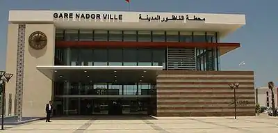
A railway linking Nador to Taourirt was opened on 2 July 2009 by king Mohammed VI of Morocco.[22][23] as part of ONCF's rail projects. Previously, there was a connecting bus link from Taourirt, also operated by railway company ONCF[24]
In addition, several direct bus links operate between Nador and major Moroccan cities. Daily ferry services link Nador Port with Almeria in Spain and a weekly service to Sète in France.
Nador International Airport offers direct flights to Moroccan and European destinations, such as cities in France and Germany, and acts as a second airport for travellers to and from Melilla.
Roads give access to the Fes-Oujda expressway and to nearby Melilla.
Economy
The main two economic industries here are fishing and agriculture. Other types of industrial income are generated from textiles, chemicals, and numerous metallurgical industries. Recently, tourism has also become an important factor for the economy.[25]
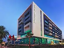
Most tourists come from other Moroccan cities,[26] but Nador has also an increasing number of European visitors, some through the international ferry connections to Spain and France.[27] Nador International Airport, in which opened in 1999,[27] also serves numerous European cities, including flights to Amsterdam, Brussels, Frankfurt, Marseille, and Barcelona. The two Nador railway stations connect to the rail network of the country of Morocco. The recent boost in tourism here has inspired ambitious tourism plans for the area, endorsed by King Mohammed VI.[28] With its avenues, palm-lined boulevards and brand new marina, hotels, cafés, banks, shops and restaurants press on to make it suitable for the fast-growing tourism industry.[10][15]
Nador has experienced a dramatic economic growth in recent years, fueled by traditional industries, such as metallurgy, and by modern ones, i.e. electronics, chemicals, and textiles. Older industries as fishing and agriculture are still the most important income for Nadoris. Beni Enzar, on the edge of Nador, is home to Nador Port, which is one of the most crucial fishing ports on the Mediterranean coast. Nador Port also has modern naval dockyards.[10] Nador's farm land is extremely fertile,[29] and the main agricultural resources are fruits, citrus, and wine-grapes.[27]
Tourism
During the summer months, Nador is visited by hundreds of thousands of Moroccan migrants living in Europe, who are originally from the province or from the city of Nador itself. These summer visitors contribute strongly to the development of the city.
Until early 2008 the city end of the boulevard was formed by the Rif Hotel, but in the spring of 2008 the existing hotel was demolished and the road alongside the boulevard opened and extended. This new road by-passes the city centre and runs directly towards the main roundabout at the entrance of Nador via the road to Tawima. The remaining grounds where the hotel and its facilities were located are being redeveloped into a new hotel complex: after some delay the new development is being built under supervision of Khalid El Adouli.[30] The new Rif complex is being built on the grounds of the former hotel minus the strip of land directly on the coast, as this is now a road and a public boulevard on reclaimed land.
The new hotel will target the high-end tourism market and also cater for business users with congress-facilities. Once re-opened it will offer a discothèque (serving alcoholic beverages) and meeting or party rooms. The hotel itself will offer 110 four-star rooms, including ten suites and also 76 apartment rooms. The budget for the redevelopment of the hotel is 356 million dirham and the total usable floorspace will be 30,000 m2 (320,000 sq ft).[31]
Just outside Nador a new ecological resort, Abdouna Trifa, is being developed, including holiday homes, a golf course and a marina. The total size of the new resort consists of 720,000 m2 (180 acres) built area on a terrain of 480 ha (1,200 acres). This ten-year development plan was started in 2008 by Mohammed VI, the king of Morocco.[32] Both this project as well as the new RIF Hotel are being developed by Compagnie Générale Immobiliere (CGI), part of the CDG Group.[33] When completed, the resort will consist of approx. 1700 "villas", 1300 apartments, a four-star and a five-star hotel. The development also includes a 27-hole golf-track and several other tourist facilities.
Azzouzi
Not much is known about the Azzouzi only that they helped with the establishment of the city and that they were and still are a Fassi family. The Azzouzi itself was the main family with branch families being led in through marriage after 100-120 years the main family name became optional but was still required to be spoken if asked for your name in which you would have said your name and begin with your surnames in order of (Main family, father, Mother,) this could be longer if your grandparents were also from a different Fassi by which you would have also been required to state this is to show which prominent families backing you have the last known family order in this logic known by the populace in Nador is (Azouzi Madmar Messbah Abdel) the Azouzi also were Illegal Gunsellers in WW2 any equipment was stolen and or bribed from the germans was slowly distributed among the local Resistance fighters it is also believed that the family Sabotaged local barracks and poisoned the germans water supplies the Azouzi are not day people in the sense that they are working behind the scenes only a hand full of people know the Azzouzi because the name passed down generation after generation. after the research, I did I understood why apparently the Azzouzi managed to stay under the populace and build their influence up in both military and political circles while staying low also making sure to have local law enforcement and politicians in their pocket. when I asked an old gentleman about it he stated that the Azzouzi has in the last 30 years amassed an entire warehouse of Firearms including but not limited to (Machineguns, Assault rifles, mortars, pistols, RPG's) when asked why he didn't tell local law enforcement the man stated he knew this because he helped them load in a couple of crates of Ak's back in 1975 by which he saw the bunker-like room filled with guns also stating somewhere WW2 firearms the local law enforcement and Military know about it but respect the Azzouzi and know that they aren't going to use them for anything Bad he stated that they are just making sure the people in the time of need can once more rely on the help of the family.
After knowing this I tried to find some more information ,after a lot of digging that the Azzouzi are Helping the city and its people a lot. I will write all my findings of their deeds under here.
- Supplying food to the Homeless
- gifting police annually 17.500.000 DHR for the upgrading of the police station and training.
- gifting police Modern firearms like Glocks and magazines and ammo for said weaponry and training instructors
- Gifting military pension and or job reintegration for soldiers
- Paying for restorations of streets in the (slums) and mosque
- Making sure there is plenty of medicine in the city and quality Care
- Youth Actions for exercise and woman protection
| Wikivoyage has a travel guide for Nador. |
References
- "POPULATION LÉGALE DES RÉGIONS, PROVINCES, PRÉFECTURES, MUNICIPALITÉS, ARRONDISSEMENTS ET COMMUNES DU ROYAUME D'APRÈS LES RÉSULTATS DU RGPH 2014" (in Arabic and French). High Commission for Planning, Morocco. 8 April 2015. Retrieved 29 September 2017.
- تاريخ الناظور (history of Nador a book only found in the oldest library in Nador where only upon request it can be viewed)
- http://www.marokko-info.nl/english/nador/
- Honnor, Julius (2012). Morocco Footprint Handbook. Footprint Travel Guides. Page 397. ISBN 9781907263316.
- Morocco. Dorling Kindersley Eyewitness Travel Guides. 2006.
- Info about Nador and Smuggling visited on 6 May 2008
- Hardy, Paula and Athony Ham (2007). Morocco. Lonely Planet. Page 208. ISBN 9781740599740.
- Seddon, David (1981). Moroccan Peasants: A Century of Change in the Eastern Rif, 1870-1970. Dawson. Page 242. ISBN 9780712909303.
- Pennell, C.R. (2000). Morocco Since 1830: A History. NYU Press. Page 329. ISBN 9780814766774.
- Warson, Lucilla (2015). DK Eyewitness Travel Guide: Morocco. Penguin. Page 162. ISBN 9781465438324.
- Hardy, Paula and Athony Ham (2007). Morocco. Lonely Planet. Page 208. ISBN 9781740599740.
- Honnor, Julius (2012). Morocco Footprint Handbook. Footprint Travel Guides. Page 397. ISBN 9781907263316.
- Seddon, David (1981). Moroccan Peasants: A Century of Change in the Eastern Rif, 1870-1970. Dawson. Page 199. ISBN 9780712909303.
- Honnor, Julius (2012). Morocco Footprint Handbook. Footprint Travel Guides. Page 398. ISBN 9781907263316.
- Clammer, Paul (2014). Lonely Planet Morocco. Lonely Planet. Page 221. ISBN 9781743600252.
- Laura M. Kidder and Sullivan, Mark (2009). Morocco. Fodors Travel Publications. Page 53. ISBN 9781400008049.
- Honnor, Julius (2012). Morocco Footprint Handbook. Footprint Travel Guides. Pages 397-398. ISBN 9781907263316.
- Clammer, Paul (2014). Lonely Planet Morocco. Lonely Planet. Page 397. ISBN 9781743600252.
- (in German) Kohlbach, Edith (2006). Reisehandbuch Marokko. Edith-Kohlbach-Reisebücher. Page 51. ISBN 9783981086829.
- Searight, Susan (1999). Maverick Guide to Morocco. Pelican Publishing. Page 272. ISBN 9781455608645.
- French, Carole (2010). National Geographic Traveler Morocco. National Geographic Books. Pages 133-134. ISBN 9781426207068.
- Le train Nador-Taourirt, enfin sur les rails Archived 2011-07-23 at the Wayback Machine, FesPub.net.
- King inaugurates Nador stations Archived 2009-08-28 at the Wayback Machine
- Timetables for the bus link can be found on the ONCF website Archived 2008-06-14 at the Wayback Machine.
- Oxford Business Group (2007). Oxford Business Group. Page 202. ISBN 9781902339764.
- Oxford Business Group (2011). Oxford Business Group. Page 123. ISBN 9781907065309.
- Searight, Susan (1999). Maverick Guide to Morocco. Pelican Publishing. Page 271. ISBN 9781455608645.
- Jacobs, Daniel and Keith Drew (2013). The Rough Guide to Morocco. Penguin. Section: Nador. ISBN 9781409332671.
- (in German) Kohlbach, Edith (2008). Ostmarokko. Edith-Kohlbach-Reisebücher. Page 36. ISBN 9783941015005.
- Profile of Khalid El-Adouli, managing architect of the new Rif hotel development. Visited: 7 September 2012
- Information on hotel redevelopment from RKempo Community site, visited 7 September 2012
- Press-release of CGI about Start of development Abdouna Trifa (French), 15 July 2008. Downloaded: 7 September 2012
- Website CGI: Our organisation Archived 2013-12-03 at the Wayback Machine (French), visited 7 September 2012
Capital: Nador | ||
| Municipalities | ||
| Rural communes | ||