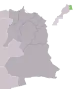
Berkane Province
Berkane Province[1] (Berber: Aberkan, ⴱⴻⵔⴽⴰⵏ, Arabic: بَركان) is located in northeastern Morocco in the area of Béni-Snassen. It is bounded by the Mediterranean to its north, the Kiss Oued (Moroccan-Algerian border) and Oujda Prefecture in the east, Nador Province to the west, and Taourirt Province in the south. The Berkane Province includes under its jurisdiction the towns of Saïdia and Ahfir. The population of the city is 80,012 as of the 2004 census. The population originates primarily from Yat Iznasen, a major tribe which consists of Berber clans. The tribe's descendants are spread widely over the rest of eastern Morocco, usually in cities like Ahfir, Saïdia and Oujda. Due to recent immigration originating from all over Morocco, the eastern dialect of Moroccan Arabic is spoken by most of the citizens, although Berber is still spoken by many of the adults.
Berkane Province
بَركان >ⵜⴰⵏⴻⴱⴹⵉⵜ ⵏ ⴱⴻⵔⴽⴰⵏ | |
|---|---|
 | |
| Country | |
| Region | Oriental |
| Capital | Berkane |
| Population (2004) | |
| • Total | 270,328 |
Berkane is considered the capital of the citrus fruit industry of Morocco, and high-quality fresh fruit and vegetables are plentiful year round. It is known for its farms of clementines mostly owned by the pro French protectorate Algerians such as Belhaj or Belhaj Bouabdallah family and the Ex drug lord Hoummad Kantari, also a large statue of an orange is at the center of town. It is very close to Saïdia, a popular beach resort town on the Mediterranean, as well as Tafoughalt, a small village in the nearby mountains known for its healthy air and herb markets. Berkane is also famous for being the birthplace of the Olympic athlete Hicham El Guerrouj, who holds the world record for the fastest mile but he has never been a major social player in the development of his native town.
Berkane is a sprawling city centered on Avenue Mohammed V, a commercial and business strip, and boulevard Ibn Sina/Rue Dehb or Alhob (meaning "The Street of Gold and or street of love" ). This boulevard is lined with many of the most popular cafés and jewelry shops. The city sprawls into the hillsides and connects via bridge to a small neighboring town named Sidi Slimane, giving the impression that it is much larger than the census claims.
Etymology
The province is named after its largest city, Berkane. The name of the city comes from the word "aberkan" which means "black" in the Berber language.
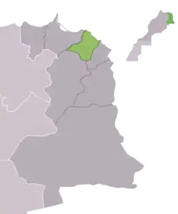
Subdivisions
The province is divided administratively into the following:[2]
| Name | Geographic code | Type | Households | Population (2004) | Foreign population | Moroccan population | Notes |
|---|---|---|---|---|---|---|---|
| Ahfir | 113.01.01. | Municipality | 4,160 | 19,482 | 310 | 19,172 | |
| Ain Erreggada | 113.01.05. | Municipality | 625 | 2,983 | 11 | 2,972 | |
| Aklim | 113.01.07. | Municipality | 1,812 | 8,969 | 5 | 8,964 | |
| Berkane | 113.01.09. | Municipality | 17,245 | 80,012 | 199 | 79,813 | |
| Saïdia | 113.01.25. | Municipality | 829 | 3,338 | 77 | 3,261 | |
| Sidi Slimane Echcharraa | 113.01.29. | Municipality | 4,561 | 22,904 | 14 | 22,890 | |
| Aghbal | 113.03.01. | Rural commune | 2,704 | 13,809 | 124 | 13,685 | |
| Fezouane | 113.03.07. | Rural commune | 2,005 | 10,304 | 21 | 10,283 | |
| Laatamna | 113.03.09. | Rural commune | 3,182 | 15,493 | 177 | 15,316 | |
| Madagh | 113.03.11. | Rural commune | 2,758 | 13,980 | 54 | 13,926 | 2,312 residents live in the center, called Madagh; 11,668 residents live in rural areas. |
| Boughriba | 113.05.03. | Rural commune | 3,727 | 20,560 | 4 | 20,556 | |
| Chouihia | 113.05.05. | Rural commune | 2,138 | 12,539 | 0 | 12,539 | |
| Rislane | 113.05.13. | Rural commune | 879 | 5,195 | 0 | 5,195 | |
| Sidi Bouhria | 113.05.15. | Rural commune | 991 | 5,400 | 1 | 5,399 | |
| Tafoughalt | 113.05.17. | Rural commune | 609 | 3,150 | 2 | 3,148 | |
| Zegzel | 113.05.19. | Rural commune | 6,424 | 32,210 | 38 | 32,172 | 16,145 residents live in the center, called Bouhdila; 16,065 residents live in rural areas. |
References
- "Berkane".
- "Recensement général de la population et de l'habitat de 2004" (PDF). Haut-commissariat au Plan, Lavieeco.com. Archived from the original (PDF) on 23 April 2012. Retrieved 27 April 2012.
Capital: Berkane | ||
| Municipalities | ||
| Rural communes | ||