Bhumlu Rural Municipality
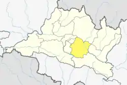
Bhumlu is a Rural municipality located within the Kavrepalanchowk District of the Bagmati Province of Nepal. The municipality spans 91 square kilometres (35 sq mi) of area, with a total population of 18,916 according to a 2011 Nepal census.[1] [2]
Bhumlu (RM)
भुमलु गाउँपालिका | |
|---|---|
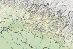 Bhumlu (RM) Location 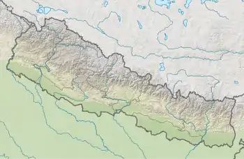 Bhumlu (RM) Bhumlu (RM) (Nepal) | |
| Coordinates: 27°36′54″N 85°45′07″E | |
| Country | |
| Province | Bagmati |
| District | Kavrepalanchowk |
| Wards | 10 |
| Established | 10 March 2017 |
| Government | |
| • Type | Rural Council |
| • Chairperson | Mr. Gumandhwaj Kunwar |
| • Vice-chairperson | Mrs. Kalpana Shrestha |
| Area | |
| • Total | 91 km2 (35 sq mi) |
| Population (2011) | |
| • Total | 18,916 |
| • Density | 210/km2 (540/sq mi) |
| Time zone | UTC+5:45 (Nepal Standard Time) |
| Headquarter | Salle Bhumlu |
| Website | bhumlumun |
On March 10, 2017, the Government of Nepal restructured the local level bodies into 753 new local level structures. [3] [4] The previous units of local governance, namely Saping, Simthali, Bekhsimle Dhartigaun, Choubas, Salle Bhumlu Kolati Bhumlu, Phalante Bhumlu, Bhumlutar, Jyamdi Mandan and Dolalghat VDCs were merged to form Bhumlu Rural Municipality. Bhumlu is divided into 10 wards, with Salle Bhumlu declared the administrative center of the rural municipality.
References
- "District Corrected Last for RAJAPATRA" (PDF). www.mofald.gov.np. Retrieved 17 July 2018.
- "स्थानीय तहहरुको विवरण" [Details of the local level bodies]. www.mofald.gov.np/en (in Nepali). Ministry of Federal Affairs and Local Development. Retrieved 17 July 2018.
- "New local level structure comes into effect from today". www.thehimalayantimes.com. The Himalayan Times. 10 March 2017. Retrieved 17 July 2018.
- "New local level units come into existence". www.kathmandupost.ekantipur.com. 11 March 2017. Retrieved 18 July 2018.
External links
This article is issued from Wikipedia. The text is licensed under Creative Commons - Attribution - Sharealike. Additional terms may apply for the media files.