Bagmati Province
Bagmati Province (Nepali: वाग्मती प्रदेश, Bagmati Pradesh)[1][2] is one of the seven provinces of Nepal established by the constitution of Nepal as of 20 September 2015.[3] With Hetauda as its provincial headquarter,[4] the province is the home to the country's capital Kathmandu, is mostly hilly and mountainous, and hosts mountain peaks including Gaurishankar, Langtang, Jugal, and Ganesh. The province covers an area of 20,300 km2 - about 13.76% of the country's total area, and has an altitude low enough to support deciduous, coniferous, and alpine forests and woodlands. Temperature varies with altitude. Rainfall takes place mainly during the summer.
Bagmati Province
बागमती प्रदेश Bagmati Pradesh | |
|---|---|
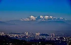
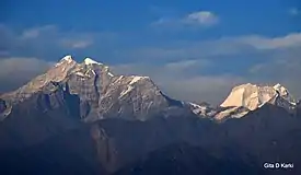 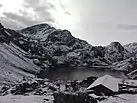 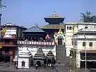 .jpg.webp) 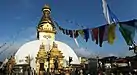 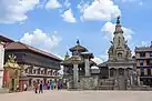 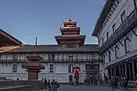 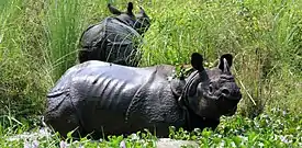 From Top left to right Gaurishankar, Gosainkunda, Pashupatinath Temple, Patan Durbar Square, Swayambhunath, Bhaktapur Durbar Square, Hanuman Dhoka and One-horned rhinoceros at Chitwan National Park | |
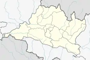
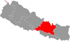 Location of Bagmati | |
Map of Bagmati, Nepal | |
| Province | |
| Formation | 20 September 2015 |
| Capital | Hetauda |
| Largest city | Kathmandu |
| Districts | 13 |
| Government | |
| • Body | Government of Bagmati |
| • Governor | Bishnu Prasad Prasain |
| • Chief Minister | Dormani Poudel (NCP) |
| • Legislature | Unicameral (110 seats) |
| • Parliamentary constituency | House of Representatives (33) National Assembly (8) |
| • High Court | Patan High Court |
| Area | |
| • Total | 20,300 km2 (7,800 sq mi) |
| Area rank | 5th |
| Population (2011) | |
| • Total | 5,529,452 |
| • Rank | 1st |
| • Density | 270/km2 (710/sq mi) |
| • Density rank | 2nd |
| Demonym(s) | Upatyakabasi Rajdhani Aaspaaska Nepali |
| Time zone | UTC+5:45 (NST) |
| Geocode | NP-TH |
| Official language | Nepali |
| Other language(s) | |
| HDI | 0.560 (medium) |
| Literacy | 74.85% |
| Sex ratio | 98.77 ♂ /100 ♀ (2011) |
| Website | ocmcm |
The province borders the Tibet Autonomous Region of China to the north, Province No. 1 to the east, Gandaki Province to the west, and both Province No. 2 and the Indian state of Bihar to the south. Hetauda was declared as the permanent state capital on January 12, 2020.[5] Being the most populous province of Nepal, it possesses rich cultural diversity with resident communities and castes including Newar, Tamang, Madhesis, Sherpa, Tharu, Chepang, Jirel, Brahmin, Chhetri and more.[6] It hosted the highest number of voters in the last election for the House of Representatives and Provincial Assembly, which took place in 2017.
Etymology
Bagmati is named after the Bagmati River which runs through the Kathmandu valley. The river is considered the source of the Newar civilization and urbanization.[7] The river has been mentioned as Vaggumuda (Nepali: वग्गुमुदा) in Vinaya Pitaka and Nandabagga.[7] It has also been mentioned as Bahumati (Nepali: बाहुमति) in Battha Suttanta of Majjhima Nikaya.[7] An inscription dated 477 A.D. describes the river as Bagvati Parpradeshe (Nepali: वाग्वति पारप्रदेशे) and subsequently in the Gopalraj Vanshavali.[7]
A provincial assembly meeting on 12 January 2020 endorsed the proposal to name the province as Bagmati by a majority vote. The meeting also endorsed Hetauda as the provincial capital.[8]
History
Historically the area of Bagmati province known as "Kathmandu Kshetra" which was established in 1956. Kathmandu Kshetra was composed by grouping the then 5 districts. Those 5 districts are now divided into many districts. Kathmandu Kshetra had total area of 6,144 square miles (15,910 km2) and total population was 17.93 Lakhs.[9]
The five districts were:
- Narayani District (Bara, Parsa, Rautahat)
- Rapti District (Chitwan, Ramechap, Makwanpur)
- Chautara District (Sindhupalchok, Kavrepalanchowk)
- Trishuli District (Nuwakot, Dhading)
- Kathmandu District (Kathmandu, Lalitpur, Bhaktapur)
In 1962, administrative system restructured and the "Kshetras" system cancelled and the country restructured into 75 development districts and those districts were grouped into zones.[10] In 1972, the region was named to Central Development Region. It had 3 zones and 19 districts.
Geography
Bagmati Province has an area of 20,300 km2 which is about 13.79% of the total area of Nepal. The elevation of the province ranges from 141 m at Golaghat in Chitwan District to 7,229 at Langtang Lirung in Rasuwa District.[11]
| Location | August
(°F) |
August
(°C) |
January
(°F) |
January
(°C) |
Annual
Precipitation (mm/in) |
|---|---|---|---|---|---|
| Banepa | 74.7 | 23.7 | 49.8 | 9.9 | 1930.8/76 |
| Bharatpur | 81.7 | 27.6 | 57.6 | 14.2 | 2550.1/100.4 |
| Hetauda | 79.7 | 26.5 | 55.2 | 12.9 | 2069.5/81.5 |
| Suryabinayak | 70.5 | 21.4 | 45.9 | 7.7 | 1821.7/71.7 |
| Kathmandu | 75 | 23 | 50 | 10 | 1360/53.6 |
| Kirtipur | 74.3 | 23.5 | 48.9 | 9.4 | 2100.9/82.7 |
Government and administration
The Governor acts as the head of the province while the Chief Minister is the head of the provincial government. The Chief Judge of the Patan High Court is the head of the judiciary.[13] The present Governor, Chief Minister and Chief Judge are Bishnu Prasad Prasain, Dormani Poudel and Tek Bahadur Moktan respectively.[14][15] The provincial assembly has 110 members while the province has 33 House of Representative constituencies.[16]
Bagmati has a unicameral legislature, like all of the other provinces in Nepal. The term length of provincial assembly is five years. The Provincial Assembly is currently housed at the Regional Education Directorate in Hetauda.[17]
Administrative divisions
Bagmati is divided into 13 districts, which are listed below. A district is administrated by the head of the District Coordination Committee and the District Administration Officer. The districts are further divided into municipalities or rural municipalities. The municipalities include three metropolitan cities, one sub-metropolitan city and 41 municipalities. There are 74 rural municipalities in the province.[18]
| Districts | Headquarters | Population (2011)[19] |
|---|---|---|
| Sindhuli District | Kamalamai | 296,192 |
| Ramechhap District | Manthali | 202,646 |
| Dolakha District | Bhimeshwar | 186,557 |
| Bhaktapur District | Bhaktapur | 304,651 |
| Dhading District | Nilkantha | 336,067 |
| Kathmandu District | Kathmandu | 1,744,240 |
| Kavrepalanchok District | Dhulikhel | 381,937 |
| Lalitpur District | Lalitpur | 468,132 |
| Nuwakot District | Bidur | 277,471 |
| Rasuwa District | Dhunche | 43,300 |
| Sindhupalchok District | Chautara | 287,798 |
| Chitwan District | Bharatpur | 579,984 |
| Makwanpur District | Hetauda | 420,477 |
Demographics
Religion in Bagmati
According to the 2011 Nepal Census, Bagmati Province has a population of 5,433,818 comprising 2,761,224 females and 2,672,594 males. The province has the highest population in the country having 20.87% of the population. The population density of the province is 270 people per square kilometre which is the second highest in the country.[20]
Ethnic groups
Tamang is the largest ethnic group in the province making up around 20.54% of the population. Hill Brahmans are the next largest group making up around 18.32% if the population followed by Chhetris (17.13%) and Newars (17.07%) respectively. Similarly Magar, Kami and Gurung make up 4.87%, 2.52% and 2.22% of the population respectively. Tharu (1.63%), Rai (1.52%), Damai (1.36%), Sarki (1.33%) and Chepang (1.16%) are other smaller ethnic groups in the province.[20]
Languages
Nepali is the most common mother tongue in the province with 57.23% of the population speaking Nepali as their mother tongues. Tamang language is spoken by 18.49% and Nepal Bhasa is spoken by 12.44% of the population as their mother tongue. Magar (1.82%), Tharu (1.33%), Maithli (1.19%), Gurung (0.93%) and Chepang (0.85%) are other languages spoken in the province.[20]
Religion
Hinduism is the most followed religion in the province with 71.78% of the population identifying as Hindus. Buddhists are the largest minority population with 23.28% of the population following Buddhism and Christianity is followed by 2.87% of the population in the province.[20]
References
- "प्रदेश ३ को नाम वाग्मती" [Province No. 3 named as Bagmati]. ekantipur.com (in Nepali). Retrieved 12 January 2020.
- "प्रदेश ३ को नाम वागमती, स्थायी राजधानी हेटौंडा तोकियो" [Province No. 3 named as Bagmati, permanent capital Hetauda]. Online Khabar (in Nepali). Retrieved 12 January 2020.
- "Nepal Provinces". statoids.com. Retrieved 21 March 2016.
- "Finally, Provincial Assembly renames Province 3 as Bagmati, picks Hetaunda as capital – OnlineKhabar". Retrieved 19 January 2020.
- "PA decides to call Province 3 Bagmati, with Hetauda as its permanent HQ". The Himalayan Times. 13 January 2020. Retrieved 2 February 2020.
- "Highest number of voters in province no. 3". Retrieved 15 April 2018.
- Article: नेपाली वास्तु र वास्तुग्रन्थको संक्षिप्त परिचय, Author: Tarananda Mishra
- "Province 3 assembly meet endorses Bagmati as the name of the province by majority votes". www.kathmandupost.com. Kantipur Media Group. 12 January 2020. Retrieved 12 January 2020.
- नेपालको जिल्ला प्रशासन पुनर्गठनको रिपोर्ट, २०१३ (PDF). Nepal: Nepal Govt. pp. 35, 36, 37.
- "Memorial Step of King Mahendra in 1st Poush 2017 BS". reviewnepal.com. 13 December 2017. Retrieved 6 February 2018.
- "पृष्ठभुमी | मुख्यमन्त्री तथा मन्त्रिपरिषद्को कार्यालय". ocmcm.bagamati.gov.np. Retrieved 26 December 2020.
- "Nepal Travel Weather Averages (Weatherbase)". Weatherbase. Retrieved 28 April 2018.
- "High Courts get their chief judges". Retrieved 27 April 2018.
- "UML PP leader Dor Mani Paudel appointed CM of Province 3". The Himalayan Times. 11 February 2018. Retrieved 27 April 2018.
- "President of Nepal administers oath to Chiefs of seven provinces | DD News". ddnews.gov.in. Retrieved 27 April 2018.
- "CDC creates 495 constituencies". The Himalayan Times. 31 August 2017. Retrieved 27 April 2018.
- "Preparations under way for assembly meeting". The Himalayan Times. 31 January 2018. Retrieved 27 April 2018.
- "स्थानिय तह". 103.69.124.141. Archived from the original on 31 August 2018. Retrieved 27 April 2018.
- 2011 Census District Level Detail Report Archived 2018-09-02 at the Wayback Machine, Central Bureau of Statistics.
- "Natioanl Data Portal-Nepal". nationaldata.gov.np. Retrieved 26 December 2020.
Places adjacent to Bagmati Province | ||||||||||
|---|---|---|---|---|---|---|---|---|---|---|
| ||||||||||
Nepal articles | ||||||||||||||||||
|---|---|---|---|---|---|---|---|---|---|---|---|---|---|---|---|---|---|---|
| History |
|  | ||||||||||||||||
| Geography |
| |||||||||||||||||
| Politics |
| |||||||||||||||||
| Economy | ||||||||||||||||||
| Culture |
| |||||||||||||||||
| ||||||||||||||||||