Bielany
Bielany is a district in Warsaw located in the north-western part of the city.
Bielany | |
|---|---|
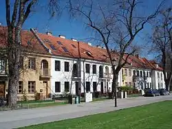 A pre-war housing estate in Old Bielany | |
 Coat of arms | |
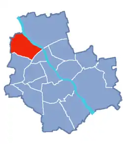 Location of Bielany within Warsaw | |
| Coordinates: 52°17′20″N 20°56′02″E | |
| Country | |
| Voivodeship | Masovian |
| County/City | Warsaw |
| Government | |
| • Mayor | Grzegorz Pietruczuk |
| Area | |
| • Total | 32.34 km2 (12.49 sq mi) |
| Population (2019) | |
| • Total | 131,910[1] |
| Time zone | UTC+1 (CET) |
| • Summer (DST) | UTC+2 (CEST) |
| Area code(s) | +48 22 |
| Website | bielany.waw.pl |
Initially a part of Żoliborz, Bielany has been an independent district since 1994. Bielany borders Żoliborz to the south-east, and Bemowo to the south-west. Its north-eastern border is the Vistula River, and the northern-western border is also the limits of the city of Warsaw.
The name 'Bielany', which in Polish is plural, derives from the white habits of the Camaldolese monks who have an ancient priory there. It is also known for the Józef Piłsudski University of Physical Education in Warsaw, which was established 1929 when it was known as the Central Institute for Physical Education (C.I.W.F.), as well as the newly built Cardinal Stefan Wyszyński University.
Neighbourhoods
- Chomiczówka
- Huta
- Las Bielański
- Marymont-Kaskada
- Marymont-Ruda
- Młociny
- Piaski
- Placówka
- Radiowo
- Stare Bielany
- Słodowiec
- Wawrzyszew
- Wólka Węglowa
- Wrzeciono
International relations
See also
References
- "Powierzchnia i ludność w przekroju terytorialnym w 2019 roku. Tabl. 21 Powierzchnia, ludność oraz lokaty według gmi". stat.gov.pl. Główny Urząd Statystyczny. Retrieved 2 September 2020.
| Wikimedia Commons has media related to Bielany. |
External links
Bielany, Warsaw | ||
|---|---|---|
| ||
This article is issued from Wikipedia. The text is licensed under Creative Commons - Attribution - Sharealike. Additional terms may apply for the media files.