Birkdale, Queensland
Birkdale is a coastal locality in the City of Redland, Queensland, Australia.[2] In the 2016 census, Birkdale had a population of 14,497 people.[1]
| Birkdale Redland City, Queensland | |||||||||||||||
|---|---|---|---|---|---|---|---|---|---|---|---|---|---|---|---|
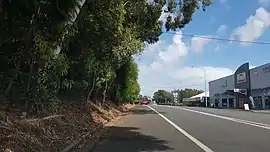 Birkdale Road, 2018 | |||||||||||||||
 Birkdale | |||||||||||||||
| Coordinates | 27.5002°S 153.2111°E | ||||||||||||||
| Population | 14,497 (2016 census)[1] | ||||||||||||||
| • Density | 1,066/km2 (2,761/sq mi) | ||||||||||||||
| Postcode(s) | 4159 | ||||||||||||||
| Area | 13.6 km2 (5.3 sq mi) | ||||||||||||||
| Location |
| ||||||||||||||
| LGA(s) | City of Redland | ||||||||||||||
| State electorate(s) | |||||||||||||||
| Federal Division(s) | Bowman | ||||||||||||||
| |||||||||||||||
Geography
Birkdale stretches from Tingalpa Creek in the west, the border with Brisbane City, to Wellington Point in the east. Thorneside and Waterloo Bay are to its north, and Capalaba and Alexandra Hills to its south.
History
Birkdale was named in 1880 by local landowner William Thorne after his birthplace, Birkdale in England.[3]
Birkdale State School opened on 27 November 1916 with 28 students.[4][5]
In the 1920s, poultry was a major industry in Birkdale.
Birkdale South State School opened on 25 January 1982.[6]
Heritage listing
There is one heritage listing in Birkdale, the School of Arts Hall on 101 Birkdale Road.[7]
Demographics
In the 2016 census, Birkdale recorded a population of 14,497 people, 50.8% female and 49.2% male.
The median age of the Birkdale population was 39 years, 2 years above the national median of 37.
75.2% of people living in Birkdale were born in Australia. The other top responses for country of birth were England 5.8%, New Zealand 4.9%, South Africa 1.3%, Netherlands 1.2%, Scotland 0.8%.
90% of people spoke only English at home; the next most common languages were 1.1% Dutch, 0.5% German, 0.5% Mandarin, 0.4% Vietnamese, 0.4% Italian.
Climate
Birkdale has a humid subtropical climate (Köppen climate classification Cfa) with hot, humid summers and mild winters.[8] From November through March, thunderstorms are common, with the more severe events accompanied by large damaging hail stones, torrential rain and destructive winds.
| Climate data for Redlands | |||||||||||||
|---|---|---|---|---|---|---|---|---|---|---|---|---|---|
| Month | Jan | Feb | Mar | Apr | May | Jun | Jul | Aug | Sep | Oct | Nov | Dec | Year |
| Record high °C (°F) | 37.5 (99.5) |
38.2 (100.8) |
35.6 (96.1) |
32.7 (90.9) |
29.3 (84.7) |
25.9 (78.6) |
27.4 (81.3) |
31.6 (88.9) |
33.4 (92.1) |
35.1 (95.2) |
36.6 (97.9) |
36.6 (97.9) |
38.2 (100.8) |
| Average high °C (°F) | 28.9 (84.0) |
28.6 (83.5) |
27.7 (81.9) |
25.9 (78.6) |
23.3 (73.9) |
21.0 (69.8) |
20.5 (68.9) |
21.5 (70.7) |
23.6 (74.5) |
25.3 (77.5) |
26.8 (80.2) |
28.2 (82.8) |
25.1 (77.2) |
| Average low °C (°F) | 19.9 (67.8) |
20.0 (68.0) |
18.6 (65.5) |
15.7 (60.3) |
12.5 (54.5) |
9.7 (49.5) |
8.2 (46.8) |
8.3 (46.9) |
11.0 (51.8) |
14.2 (57.6) |
16.7 (62.1) |
18.7 (65.7) |
14.5 (58.1) |
| Record low °C (°F) | 9.5 (49.1) |
13.0 (55.4) |
10.9 (51.6) |
5.0 (41.0) |
2.3 (36.1) |
1.0 (33.8) |
0.0 (32.0) |
0.1 (32.2) |
2.6 (36.7) |
4.2 (39.6) |
5.7 (42.3) |
9.2 (48.6) |
0.0 (32.0) |
| Average precipitation mm (inches) | 154.3 (6.07) |
161.5 (6.36) |
163.2 (6.43) |
105.7 (4.16) |
113.2 (4.46) |
87.6 (3.45) |
61.8 (2.43) |
52.4 (2.06) |
39.1 (1.54) |
84.0 (3.31) |
104.5 (4.11) |
143.7 (5.66) |
1,269.1 (49.96) |
| Average precipitation days | 11.5 | 12.9 | 12.8 | 11.3 | 10.2 | 8.1 | 7.2 | 6.2 | 7.0 | 9.1 | 10.2 | 10.7 | 117.2 |
| Source: Bureau of Meteorology[9] | |||||||||||||
Notable citizens
- Peter Airley (1865-1950), school teacher, politician and writer[10]
- Wally Lewis (01/12/59-), Rugby League player, sports presenter
- Mirusia Louwerse (29 March 1985 -), opera singer[11]
- George Randall (1843-1930), confectionery manufacturer, migration officer and orchardist[12]
Major features
Major features of Birkdale are a railway station, a canal style housing development known as Aquatic Paradise, a significant shopping precinct located near Aquatic Paradise and a retirement village known as Wellington Manor.
It is also home to one of the Redlands Waste Transfer Stations (27.5089°S 153.2264°E), which (as of July 2012) is provided to the residents of the city free of charge. It encourages residents to recycle such items as green waste, cardboard etc. and helps in the proper disposal of hazardous materials.[13]
Schools
Birkdale State School is a government primary (P-6) school for boys and girls at 74 Agnes Street (corner of Birkdale Road).[14] In 2017, the school had an enrolment of 646 students, predominantly drawn from the suburbs of Thorneside and Birkdale, with 43 teachers (39 full-time equivalent) and 20 non-teaching staff (15 full-time equivalent).[5]
Birkdale South State School is a government primary (P-6) school for boys and girls at 451 Old Cleveland Road East.[15] In 2017, the school had an enrolment of 583 students with 44 teachers (37 full-time equivalent) and 19 non-teaching staff (14 full-time equivalent). The school's catchment area has transitioned from small crop farms to residential estates.[16]
Transport
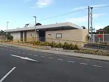
Birkdale railway station provides access to regular Queensland Rail City network services to Brisbane and Cleveland.
Sporting clubs
Youth organisations
- Birkdale Scout Group[20]
References
- Australian Bureau of Statistics (27 June 2017). "Birkdale (SSC)". 2016 Census QuickStats. Retrieved 3 November 2018.

- "Birkdale – locality in City of Redland (entry 48175)". Queensland Place Names. Queensland Government. Retrieved 11 October 2017.
- "Birkdale (entry 43627)". Queensland Place Names. Queensland Government. Retrieved 20 April 2014.
- "Agency ID 4850, Birkdale State School". Queensland State Archives. Retrieved 20 April 2014.
- "Annual Report 2017" (PDF). Birkdale State School. Archived (PDF) from the original on 3 November 2018. Retrieved 3 November 2018.
- "Agency ID 10758, Birkdale South State School". Queensland State Archives. Retrieved 20 April 2014.
- "Schedule 4 - Heritage Places Register" (PDF). Redland City Council. March 2006. p. 2. Archived (PDF) from the original on 5 September 2020. Retrieved 5 September 2020.
- Linacre, Edward; Geerts, Bart (1997). Climates and Weather Explained. London: Routledge. p. 379. ISBN 0-415-12519-7. Archived from the original on 24 June 2016. Retrieved 23 September 2016.
- "Redlands HRS". Climate statistics for Australian locations. Bureau of Meteorology. Retrieved 19 June 2011.
- Sullivan, Martin (1879). "Airey, Peter (1865–1950)". Archived from the original on 4 April 2015. Retrieved 3 February 2018.
- "Mirusia". Mirusia. Archived from the original on 3 February 2018. Retrieved 3 February 2018.
- Harrison, Jennifer (2005). "Randall, George (1843–1930)". Australian Dictionary of Biography. Archived from the original on 3 February 2018. Retrieved 3 February 2018.
- "Waste transfer stations". Redland City Council. Archived from the original on 21 April 2014. Retrieved 20 April 2014.
- "Birkdale State School". Queensland Government. Archived from the original on 20 April 2013. Retrieved 18 June 2015.
- "Birkdale South State School". Queensland Government. Archived from the original on 30 May 2014. Retrieved 18 June 2015.
- "Annual Report 2017" (PDF). Birkdale South State School. Archived (PDF) from the original on 3 November 2018. Retrieved 3 November 2018.
- "Archived copy". Archived from the original on 31 July 2008. Retrieved 18 February 2009.CS1 maint: archived copy as title (link)
- "Home - Bayside Ravens Gridiron Club Inc - revolutioniseSPORT". www.baysideravens.com. Archived from the original on 13 May 2016. Retrieved 19 April 2018.
- "Archived copy". Archived from the original on 27 August 2009. Retrieved 3 September 2009.CS1 maint: archived copy as title (link)
- http://birkdale.scoutsqld.com.au Archived 17 March 2012 at the Wayback Machine
External links
| Wikimedia Commons has media related to Birkdale, Queensland. |