Redland Bay, Queensland
Redland Bay is a coastal semi-rural locality in the City of Redland, Queensland, Australia.[2] In the 2016 census, Redland Bay had a population of 14958 people.[1]
| Redland Bay Redland City, Queensland | |||||||||||||||
|---|---|---|---|---|---|---|---|---|---|---|---|---|---|---|---|
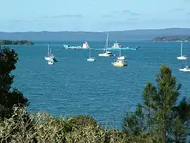 Redland Bay Passage featuring vehicular ferries servicing the Bay Islands | |||||||||||||||
 Redland Bay | |||||||||||||||
| Coordinates | 27.6450°S 153.2855°E | ||||||||||||||
| Population | 14,958 (2016 census)[1] | ||||||||||||||
| • Density | 285.46/km2 (739.3/sq mi) | ||||||||||||||
| Postcode(s) | 4165 | ||||||||||||||
| Area | 52.4 km2 (20.2 sq mi) | ||||||||||||||
| Time zone | AEST (UTC+10:00) | ||||||||||||||
| Location | 36 km (22 mi) from Brisbane GPO | ||||||||||||||
| LGA(s) | Redland City | ||||||||||||||
| State electorate(s) | Redlands | ||||||||||||||
| Federal Division(s) | Bowman | ||||||||||||||
| |||||||||||||||
Since the first European settlers arrived in the mid-19th century, Redland Bay has remained a farming and fishing-based area until the mid-20th century when some of the farms were subdivided and improved transport infrastructure made it possible for residents to commute the 35 kilometers into Brisbane.
Geography
Redland Bay is at the southern end of Redland City, 35 kilometres (22 mi) south-east of Brisbane, the capital of Queensland.
The locality is named for the bay it sits on, which forms part of larger Moreton Bay.
The redness of Redland Bay soil derives from iron oxides present in lava from a volcano that erupted (millions of years ago) in northern New South Wales, some 100 kilometres to the south.
The locality is a port for vessels plying the bay islands. These islands include Russell Island, Macleay Island, Karragarra Island, Lamb Island and North Stradbroke Island, home to several thousand residents.
History
The Aboriginal name for the Redland Bay region was Talwalpin after the cottonwood tree which was widespread in the area.[3]
In the 1860s, settlers from England, Germany and Scandinavia began filtering into and along the Logan River and surrounding districts. They found dense forests growing from generally good soil. Particularly rich was the soil of the Redland Bay District which is said to have had lush rainforest complete with prized red cedar.[4]
The labour of clearing the forest was long and arduous. One man with an axe might labor for years to clear an area of land that could support a viable farm. The felled timber would then milled to provide building material for the first houses. Locally milled cedar was used for doors, architraves and other feature work on the early houses, such as the original farmhouse on what was to become Mt Carmel Orchard. The character of the red soil was such that over time, it infiltrated itself into and on farm buildings, giving them a characteristic red tinge.
.jpg.webp)
One early settler was Arnold Friedrich Muller who took up 50 acres (20 ha) of coastal forest north of what is now Point Talburpin. Muller's farmhouse was removed in the 1990s to make way for a stage of the Orchard Beach estate, but its site is still marked by a pair of mature fig trees, planted around 1905, at the top of School of Arts road where it meets Collins Street. While these trees were likely to have been planted for the practical purposes of shading the house from the intense afternoon sun and cold winter westerly winds, they also stand as a symbol of the enduring husband and wife farming partnerships that helped to define the character of Redland Bay. Arnold's eldest son William was born around 1879, the first white man to be born in the district. He died in 1978 at the age of 99.
The early farms produced sugar cane, pineapples and citrus. The produce was taken to market by horse-drawn wagon at first, then by the steamboats Pearl, Eucalypta, Louisa and Porpoise, operated by one Captain John Burke. The viability of these crops was reduced as larger farms to the north at Thorneside, Cleveland and Ormiston gained a competitive advantage over Redland Bay, possibly due to access to rail transport. Redland Bay farmers moved towards producing tomatoes, cabbage, cauliflower and passionfruit. These crops continued until farming finally gave way to suburban development around the year 2000.
Redland Bay Provisional School opened on 14 December 1881 as a half time school in conjunction with Victoria Point Provisional School (meaning a single teacher was shared between two schools). In 1890,[5] it became Redland Bay State School.[6]
On 10 November 1884, auctioneer John Cameron offered 451 suburban lots in the Redland Bay Estate, an area bounded by North Street to the north, Moreton Bay to the east, Boundary Street to the south and Mill Street to the west.[7] The lots were advertised as having either a water frontage or splendid view of the bay and that there was a local sawmill able to provide timber for construction. The auctioner provided steamships to bring the buyers from Brisbane to the auction. The advertising also claimed the Cleveland railway line would be extended to Redland Bay (which never occurred).[8] Another auction was held for this estate on 26 December 1884.[9]
On 7 March 1885, auctioneer John Cameron offered 161 suburban lots (mostly 20 perches) bounded by Peel Street to the north, Moreton Bay to the east, Weinham Creek to the south and Scott and Hamilton Streets to the west, in addition to four banana farms (6 to 8 acres). One of the many benefits of the estate was the availability of "pure milk (no tadpoles)".[10][11]
On 9 November 1885, auctioneer Arthur Martin & Co offered 780 suburban lots (mostly 16 perches) in the Torquay Estate, an area bounded by Torquay Road to the north, Moreton Bay to the east, Oakland Avenue to the south and Serpentine Creek Road to the west.[12] As well as promising a future railway connection, the advertising also speculated "If coal is discovered, of which there is every reasonable probability, Redland is bound to become the Newcastle of Queensland, and one of the most important places in Australia".[13]
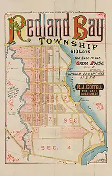
On 22 September 1888, auctioneer R.J. Cottell offered 610 lots (mostly suburban blocks ranging from 20 to 42 perches) expanding the Redland Bay estate westward to the Moogurrapum Creek and southward to Pitt Street (with some larger farm blocks beyond those boundaries). The auction took place at the Brisbane Opera House in Queen Street.[14][15]
On 18 March 1889, auctioneer A. Martin & Co offered 109 lots, including some still unsold in the original Redland Bay Estate as well as some additional lots in the vicinity of Broadwater Terrace.[16][17]
In Barry Kidd's 1979 Redland illustrated History [18] he writes 'Redland Bay is arguably the most unchanged and fertile land within the entire Redlands area. The suburban sprawl has managed only scant inroads to a few pockets of land, but the remaining farmers have stubbornly resisted even the juiciest of offers from land developers, preferring a continuation of their inherited lifestyle.'
In the two decades that followed, the decision was made by the Redland Shire Council to permit suburban development in and around Redland Bay. With land zoning changing from rural to residential, and the corresponding steep rise in rates (local government land tax), Redland Bay's farmers found they could no longer compete with other farming areas not as close to a major metropolitan area. One by one the farms were sold to land development companies, and Redland Bay, by the year 2002 farming had all but ceased.
From 2000, Redland Bay has been increasingly populated. Most farms have been replaced by housing, and has its own set of shops. It is relatively close to Victoria Point, and is only a ferry ride away from the bay islands, such as Russell and Macleay.
Heritage listings
Redland Bay has a number of heritage-listed sites, including:
- 46-72 Banana Street: Roll of Honour [19]
- 1-5 Collins Street: House with cropped pyramid roof [19]
- 125-141Gordon Road: Redland Bay State School Residence [19][20]
- Moores Road: Moreton Bay Figs[19]
- 398-408 Serpentine Creek Road: Serpentine Creek Road Cemetery [19][21]
Redland Bay Flying Boat Base
From 1953 to 1971, Qantas Empire Flying Boats operated from Redland Bay. These were mainly Sunderland flying boats traveling from Sydney to the United Kingdom. Ansett, formerly known as Barrier Reef Airways also operated flying boats from Redland Bay, taking tourists to Hayman Island in North Queensland.[22]
Redland Bay was the closest suitable site to Brisbane for a water airport. Since it operated international flights, Brisbane Water Airport at Redland Bay became Brisbane's International Airport for a time.
Pre-1946, flying boats used the Hamilton Reach of the Brisbane River. The State and Federal Governments argued for several years over the continued use of the Hamilton Reach, which was congested with shipping and unusable after dark.
Activity at Redland Bay reached its peak in the 1950s with 105 commercial flying boat movements in July 1953. There was a steady decline after that until the base was finally closed in 1971. After 1971, Qantas began operating the new Boeing 747 long-haul aircraft that made the Flying Boats obsolete.
The terminal for the Flying Boat Base was at Banana Street, Redland Bay, near the present location of the Bay Island ferry service. Flying boat passengers waiting to embark, and those in transit could wait and be refreshed at the Redland Bay Hotel while the Flying Boats were serviced for the onward journey.
The flying boat would leave Rose Bay in Sydney at 7:30pm and arrive at Redland Bay at around 11:00pm. Two hours later, she was back in the air, en route to Nouméa in New Caledonia, where passengers would go ashore for breakfast. Several days, and many stops later, the flying boat would arrive in London. By contrast, in 2009, travelling on a long-haul 747, passengers can fly direct from Brisbane to London via Singapore in less than 24 hours for a mere fraction of the cost.
The arrival of the flying boat in Redland Bay near midnight did not go unnoticed by the local residents. A powerful searchlight swept the watery runway to guide the pilot. Launches carrying passengers, luggage, fuel, freight, refreshments and mail made their way to and from the moored flying boat. Voices carried clearly across the calm water.
The Qantas service to Nouméa flying boat came to and end in the mid-fifties, to be replaced by direct flights between Sydney and la Tontouta airport by DC4, DC6b, Lockheed Electra, Boeing 707 and Boeing 747 successively.
Amenities
The Redland City Council operates a mobile library service which visits Stradbroke Street.[23]
Education
Redland Bay State School is a government primary (Prep-6) school for boys and girls at Gordon Road (27.6185°S 153.2930°E).[24][25] In 2017, the school had an enrolment of 876 students with 65 teachers (56 full-time equivalent) and 42 non-teaching staff (27 full-time equivalent).[26] It includes a special education program.[24][27]
Demographics
In the 2011 census, Redland Bay recorded a population of 13,624 people, 50.3% female and 49.7% male.
The median age of the Redland Bay population was 37 years, the same as the national median.
75.2% of people living in Redland Bay were born in Australia. The other top responses for country of birth were England 7.6%, New Zealand 5.2%, South Africa 1.7%, Scotland 0.9%, Germany 0.6%.
92.7% of people spoke only English at home; the next most common languages were 0.6% Afrikaans, 0.3% German, 0.2% Dutch, 0.2% Italian, 0.2% Spanish.
References
- Australian Bureau of Statistics (27 June 2017). "Redland Bay (SSC)". 2016 Census QuickStats. Retrieved 20 October 2018.

- "Redland Bay – locality in City of Redland (entry 43632)". Queensland Place Names. Queensland Government. Retrieved 17 November 2019.
- Mary Howells (2000). "Places of the Redlands: Redland Bay" (PDF). Archived (PDF) from the original on 27 March 2011. Retrieved 21 April 2012.
- Seeing South-East Queensland (2nd ed.). RACQ. 1980. p 31. ISBN 0-909518-07-6
- "Redland Bay State School". The Week. XXIX (753). Queensland, Australia. 31 May 1890. p. 20. Archived from the original on 5 September 2020. Retrieved 24 November 2019 – via National Library of Australia.
- Queensland Family History Society (2010), Queensland schools past and present (Version 1.01 ed.), Queensland Family History Society, ISBN 978-1-921171-26-0
- "Redland Bay [Estate]". State Library of Queensland. 1884. hdl:10462/deriv/253882. Cite journal requires
|journal=(help) - "Classified Advertising". The Brisbane Courier. XXXIX (8, 367). Queensland, Australia. 3 November 1884. p. 7. Archived from the original on 5 September 2020. Retrieved 21 May 2019 – via National Library of Australia.
- "The second section of the Redland Bay Estate". State Library of Queensland. 1884. hdl:10462/comp/10412. Cite journal requires
|journal=(help) - "The third section of the Redland Bay Estate". State Library of Queensland. 1885. hdl:10462/comp/10413. Cite journal requires
|journal=(help) - "Advertising". The Telegraph (3, 887). Queensland, Australia. 2 March 1885. p. 8. Archived from the original on 5 September 2020. Retrieved 21 May 2019 – via National Library of Australia.
- "Torquay Estate [Redland Bay]". State Library of Queensland. 1885. hdl:10462/deriv/18450. Cite journal requires
|journal=(help) - "Advertising". Queensland Figaro And Punch. VI (148). Queensland, Australia. 7 November 1885. p. 14. Archived from the original on 5 September 2020. Retrieved 21 May 2019 – via National Library of Australia.
- "Plan of the whole of the unsold allotments of the Redland Bay township". State Library of Queensland. 1888. hdl:10462/deriv/18396. Cite journal requires
|journal=(help) - "Classified Advertising". The Brisbane Courier. XLV (9, 576). Queensland, Australia. 22 September 1888. p. 12. Archived from the original on 5 September 2020. Retrieved 21 May 2019 – via National Library of Australia.
- "Redland Bay Estate". State Library of Queensland. 1889. hdl:10462/deriv/411238. Cite journal requires
|journal=(help) - "Classified Advertising". The Brisbane Courier. XLV (9, 726). Queensland, Australia. 18 March 1889. p. 8. Archived from the original on 5 September 2020. Retrieved 21 May 2019 – via National Library of Australia.
- Kidd, Barry. Redlands Illustrated History, 1979, Jackson O' Sullivan (Qld)
- "Schedule 4 - Heritage Places Register" (PDF). Redland City Council. March 2006. p. 2. Archived (PDF) from the original on 5 September 2020. Retrieved 5 September 2020.
- "Redland Bay State School Residence (entry 601369)". Queensland Heritage Register. Queensland Heritage Council. Retrieved 12 July 2013.
- "Serpentine Creek Road Cemetery (entry 601927)". Queensland Heritage Register. Queensland Heritage Council. Retrieved 12 July 2013.
- Jones, David Embry. Wings on the River: Flying Boats on the Brisbane River and Redland Bay. Boolarong Press 2007. ISBN 978-1-921054-27-3
- "Mobile Library". Redland City Council. Archived from the original on 30 January 2018. Retrieved 31 January 2018.
- "State and non-state school details". Queensland Government. 9 July 2018. Archived from the original on 21 November 2018. Retrieved 21 November 2018.
- "Redland Bay State School". Archived from the original on 12 March 2020. Retrieved 21 November 2018.
- "ACARA School Profile 2017". Archived from the original on 22 November 2018. Retrieved 22 November 2018.
- "Redland Bay SS - Special Education Program". Archived from the original on 12 March 2020. Retrieved 21 November 2018.
Further reading
- Redland Bay State School (1981). Redland Bay State School 1881-1981. Redland Bay State School. ISBN 978-0-9593691-0-6.
External links
| Wikimedia Commons has media related to Redland Bay, Queensland. |
- "Redland Bay". Queensland Places. Centre for the Government of Queensland, University of Queensland.
- Redlands Tourism
- Serpentine Creek Cemetery: Headstone Photos