Capalaba, Queensland
Capalaba /kəˈpæləbɑː/ is an urban locality in the City of Redland, Queensland, Australia.[2] In the 2016 census, Capalaba had a population of 17,333 people.[3]
| Capalaba Redland City, Queensland | |||||||||||||||
|---|---|---|---|---|---|---|---|---|---|---|---|---|---|---|---|
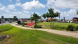 Intersection opposite Capalaba Park, 2018 | |||||||||||||||
 Capalaba | |||||||||||||||
| Coordinates | 27°31′22.78″S 153°11′33.72″E | ||||||||||||||
| Population | 17,333 (2016 census)[1] | ||||||||||||||
| Postcode(s) | 4157 | ||||||||||||||
| Location | 19 km (12 mi) from Brisbane GPO | ||||||||||||||
| LGA(s) | Redland City | ||||||||||||||
| State electorate(s) | Capalaba | ||||||||||||||
| Federal Division(s) | Bowman | ||||||||||||||
| |||||||||||||||
Geography
The suburb has large shopping and commercial centres with two malls and a major bus station, as well as light industrial zones surrounded by bushland and residential streets, making it the second most populous suburb in the Redlands.[4] Surrounding suburbs include Alexandra Hills, Birkdale, and Sheldon, also in Redland City, along with Burbank and Chandler (and formerly Capalaba West), which lie within Brisbane.
Tingalpa Creek marks the border between Capalaba in the east and the City of Brisbane in the west,[5] making the suburb a gateway to the coastal Redlands region for urban Brisbanites.[4]
History

The name of Capalaba is believed to be derived from the Indigenous Yugarabul word for the ringtail possum, a marsupial native to the area.[6][7]
European settlement began in the 1850s, led by farmers, lumberjacks, and sawmill operators.[6][8] The town became important in the overland trade link between the settlements of Brisbane and Cleveland. Crossings and bridges over Tingalpa Creek were established to facilitate such transport.[5][8]
The town was originally officially known as Tingalpa, presumably taking its name from the creek, this caused confusion due to the existence of another area of the same name and so in 1927 the town's name was officially changed to Capalaba (a name in common use).[9]
The town grew into the 20th century, becoming a major source of freshwater for the then Redland Shire in the 1960s, due to the construction of the Leslie Harrison Dam.[5] This prompted and the introduction of commercial and industrial areas still present today.[8] Continued population growth led to Capalaba ceasing to be a separate town and becoming a suburb within a larger conurbation.
Capalaba West was a related suburb located on the opposite side of Tingalpa Creek, rendering it part of Brisbane rather than the Redlands.[7] It retained the Capalaba name until 2010, when it became incorporated into the Brisbane suburb of Chandler.[10]
Demographics
In the 2016 census, the population of Capalaba was 17,333, an increase from 16,644 in the 2011 census,[11] of whom 50.4% were female and 49.6% were male. The median age of the Capalaba population was 37 years old, 1 year below the national median of 37.
74.4% of people living in Capalaba were born in Australia. The other top responses for country of birth were New Zealand (6.6%), England (4.4%), South Africa (1.0%), the Philippines (1.0%), and India (0.9%). 87.7% of people speak English as their first language; the next most common languages were Mandarin Chinese (0.6%), Hindi, Tagalog, Italian, and Greek (all 0.5%).[12]
Features
.jpg.webp)

Major commercial and educational features of Capalaba include:
- Capalaba Park Shopping Centre - the centre opened to the public in 1981 on the site of Queensland's first drive-in theatre.[13][14] The theatre was originally relocated to a new site behind the shopping centre, but then closed entirely in 1997 following an expansion of the centre to include new cinemas.[15] FPDSavills' Byvan division gave the centre its "Shopping Centre of the Year Award" in 2002.[16]
- Capalaba Central Shopping Centre[17]
- Event Cinemas movie theatre
- Capalaba State College
- The College Markets (formerly Chandler Markets)[18]
- Coolnwynpin State School[19]
- St Luke's Catholic Parish School[20]
- Capalaba Library operated by the Redland City Council at 14 Noleen Street (opened 1996)[21][22]
- Redland City Council Chambers
- Redlands IndigiScapes Centre (environmental education centre)[4][23]
- Capalaba bus station
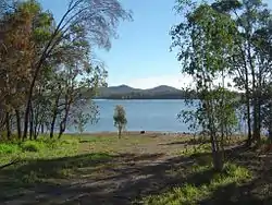
- Leslie Harrison Dam on Tingalpa Creek
Transport
The Capalaba bus station[24] connects the suburb to much of the Redlands and Eastern Brisbane. Services to Garden City bus station and the adjacent Upper Mount Gravatt busway station are operated by Mt Gravatt Bus Service, on behalf of TransLink. The suburb is also connected west to Carindale bus station and the Brisbane central business district, north to the Cleveland railway line, and east to Victoria Point bus station, through bus routes operated by Transdev Queensland on behalf of TransLink.[24]
TransLink's Eastern Busway is planned to extend from UQ Lakes to Capalaba, but currently only reaches Langlands Park busway station in Coorparoo.[25][26]
Capalaba is also the terminus for major roads crossing Tingalpa Creek from the City of Brisbane, including Old Cleveland Road and Mount Gravatt-Capalaba Road/Mount Cotton Road, both connecting directly to the Gateway Motorway.[27][28]
Sporting clubs
- Capalaba Sports Club[29]
- Capalaba District Junior Rugby League Football Club (aka the Capalaba Warriors)
- Capalaba Football Club (formerly the Capalaba Bulldogs), who play in the Brisbane Premier League
References
- Australian Bureau of Statistics (27 June 2017). "Capalaba (State Suburb)". 2016 Census QuickStats. Retrieved 14 April 2018.

- "Capalaba – locality in City of Redland (entry 43628)". Queensland Place Names. Queensland Government. Retrieved 5 November 2019.
- Australian Bureau of Statistics (27 June 2017). "Capalaba (SSC)". 2016 Census QuickStats. Retrieved 20 October 2018.
- "Redland City Tourism Strategy and Action Plan 2015-2020" (PDF). Redland City Council. Archived (PDF) from the original on 22 July 2015. Retrieved 17 July 2015.
- "Living on the Edge: along Tingalpa Creek" (PDF). Mary Howells, University of Queensland. Archived (PDF) from the original on 20 May 2015. Retrieved 17 July 2015.
- "Capalaba". Redland City Council. Archived from the original on 22 July 2015. Retrieved 17 July 2015.CS1 maint: unfit URL (link)
- "Capalaba West: Environment". BRISbites. Archived from the original on 20 July 2008. Retrieved 17 July 2015.
- "Capalaba timeline". Redland City Council. Archived from the original on 30 May 2016. Retrieved 17 July 2015.CS1 maint: unfit URL (link)
- "NEW NAME". Sunday Mail (237). Queensland, Australia. 11 December 1927. p. 3. Retrieved 14 November 2019 – via National Library of Australia.
- "Capalaba West suburb Name Change". Councillor Adrian Schrinner. May 2010. Archived from the original on 1 March 2015. Retrieved 17 July 2015.
- Australian Bureau of Statistics (31 October 2012). "Capalaba (State Suburb)". 2011 Census QuickStats. Retrieved 16 February 2014.
- Australian Bureau of Statistics (27 June 2017). "Capalaba (State Suburb)". 2016 Census QuickStats. Retrieved 18 July 2017.
- "Then and now: Redlands history in photos". Redland City Bulletin. Australian Community Media. 17 May 2013. Retrieved 13 February 2020.
- "THROWBACK THURSDAY". Redland City Bulletin. Australian Community Media. 3 October 2013. Retrieved 13 February 2020.
- Hurst, Brian (8 April 2013). "Shopping takes over from drive-in". Redland City Bulletin. Australian Community Media. Retrieved 13 February 2020.
- "Capalaba beats its rival to top award". 29 July 2002. Archived from the original on 21 October 2012. Retrieved 6 October 2008.
- "Capalaba Central Shopping Centre". www.capalabacentral.com.au. Archived from the original on 17 April 2018. Retrieved 13 May 2018.
- "Chandler Markets move to Capalaba". Redland City Bulletin. 12 August 2014. Archived from the original on 20 July 2015. Retrieved 17 July 2015.
- "Welcome to Coolnwynpin State School". coolnwynss.eq.edu.au. Archived from the original on 27 January 2014. Retrieved 13 May 2018.
- "St Lukes Capalaba". www.stlukescapalaba.qld.edu.au. Retrieved 13 May 2018.
- "Library opening hours and locations". Redland City Council. Archived from the original on 30 January 2018. Retrieved 31 January 2018.
- "Public Libraries Statistical Bulletin 2016-17" (PDF). Public Libraries Connect. State Library of Queensland. November 2017. p. 15. Archived (PDF) from the original on 30 January 2018. Retrieved 30 January 2018.
- "Conserving our natural heritage". www.indigiscapes.com.au. Archived from the original on 16 March 2018. Retrieved 13 May 2018.
- "Capalaba station". TransLink. Retrieved 17 July 2015.
- "Eastern Busway". TransLink. Archived from the original on 21 July 2015. Retrieved 17 July 2015.
- "Revitalisation of the Coorparoo Junction Precinct". Anissa Farrell, Sourceable. 27 May 2015. Archived from the original on 21 July 2015. Retrieved 17 July 2015.
- "THE ORIGINS OF OLD CLEVELAND ROAD" (PDF). Fr. Michael A Endicott, University of Queensland. 28 October 1976. Archived (PDF) from the original on 22 July 2015. Retrieved 17 July 2015.
- "Southeast Queensland road closures, cancellations and advice". The Courier-Mail. 20 February 2015. Retrieved 17 July 2015.
- "Home - Capalaba Sports Club". Capalaba Sports Club. Archived from the original on 17 March 2018. Retrieved 13 May 2018.
External links
| Wikimedia Commons has media related to Capalaba, Queensland. |