Blackmans Bay, Tasmania
Blackmans Bay is a beachside suburb of Hobart, Tasmania, Australia.
| Blackmans Bay Hobart, Tasmania | |||||||||||||||
|---|---|---|---|---|---|---|---|---|---|---|---|---|---|---|---|
 2008 | |||||||||||||||
 Blackmans Bay | |||||||||||||||
| Coordinates | 42°59′56″S 147°19′8″E | ||||||||||||||
| Population | 7,145 (2016 census)[1] | ||||||||||||||
| Postcode(s) | 7052 | ||||||||||||||
| LGA(s) | Kingborough | ||||||||||||||
| Federal Division(s) | Franklin | ||||||||||||||
| |||||||||||||||
Blackmans Bay south of Hobart was named after a James Blackman who occupied land there in the 1820s while another "Blackman Bay", near Dunalley (also in Tasmania) was so named in 1642 because of the presence of Aboriginal people.
The town is located adjacent to Kingston, and is approximately fourteen kilometres south of Hobart.
Blackmans Bay has three primary schools from kindergarten to grade six: Blackmans Bay, Illawarra, established in the late 1980s, and the Catholic St. Aloysius. There is also a beach and shopping centre within walking distance of most homes.
The shopping centre named Bayview includes a supermarket, newsagency, doctor's surgery, pharmacy and a variety of other stores.
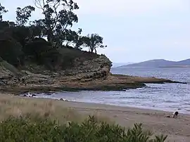
There is a blowhole near the northern end of the beach, which in reality is more like a large rock arch where waves can be seen coming in and crashing on the rocks. There are numerous cliffs and viewpoints along Blowhole Road.
On the southern side of the beach there is a track that leads to Flowerpot Point. This is a popular spot for fishing, although snags are an issue because of the prevalence of seaweed and rock ledges beneath the water.
| Climate data for Blackmans Bay | |||||||||||||
|---|---|---|---|---|---|---|---|---|---|---|---|---|---|
| Month | Jan | Feb | Mar | Apr | May | Jun | Jul | Aug | Sep | Oct | Nov | Dec | Year |
| Average high °C (°F) | 21.6 (70.9) |
21.6 (70.9) |
20.1 (68.2) |
17.3 (63.1) |
14.4 (57.9) |
12.0 (53.6) |
11.6 (52.9) |
13.0 (55.4) |
15.1 (59.2) |
16.9 (62.4) |
18.7 (65.7) |
20.3 (68.5) |
16.9 (62.4) |
| Average low °C (°F) | 11.9 (53.4) |
12.0 (53.6) |
10.8 (51.4) |
8.9 (48.0) |
7.0 (44.6) |
5.2 (41.4) |
4.5 (40.1) |
5.2 (41.4) |
6.4 (43.5) |
7.7 (45.9) |
9.2 (48.6) |
10.8 (51.4) |
8.3 (46.9) |
| Average precipitation mm (inches) | 47.7 (1.88) |
40.3 (1.59) |
45.2 (1.78) |
51.3 (2.02) |
46.3 (1.82) |
53.8 (2.12) |
52.5 (2.07) |
52.8 (2.08) |
52.5 (2.07) |
61.8 (2.43) |
53.9 (2.12) |
56.9 (2.24) |
615.0 (24.21) |
References
- Australian Bureau of Statistics (27 June 2017). "Blackmans Bay (State Suburb)". 2016 Census QuickStats. Retrieved 14 April 2018.
