Blythewood, South Carolina
Blythewood is a suburb of Columbia, South Carolina, in Richland and Fairfield counties, South Carolina. 2020 estimates put the population at 4,446[5] up from 2,034 in 2010.[6] Since 2000 it has had a population boom, going from 170 people in 2000 to a population of 2,034 in 2010, representing an increase of 1096%. It is part of the Columbia, South Carolina, Metropolitan Statistical Area. It is located around 15 miles (24 kilometers) from downtown Columbia.
Blythewood, South Carolina | |
|---|---|
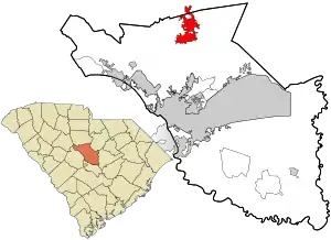 Location in Richland County and the state of South Carolina. | |
| Coordinates: 34°13′5″N 80°59′5″W | |
| Country | United States |
| State | South Carolina |
| Counties | Richland, Fairfield |
| Area | |
| • Total | 10.71 sq mi (27.74 km2) |
| • Land | 10.63 sq mi (27.53 km2) |
| • Water | 0.08 sq mi (0.22 km2) |
| Elevation | 499 ft (152 m) |
| Population (2010) | |
| • Total | 2,034 |
| • Estimate (2019)[2] | 4,446 |
| • Density | 390.44/sq mi (150.75/km2) |
| Time zone | UTC-5 (EST) |
| • Summer (DST) | UTC-4 (EDT) |
| ZIP code | 29016 |
| Area code(s) | 803, 839 |
| FIPS code | 45-07255[3] |
| GNIS feature ID | 1245688[4] |
| Website | www |
Blythewood Road is one of the main thoroughfares, intersecting Interstate 77 at Exit 27. U.S. Route 21 also goes through Blythewood, Intersecting Interstate 77 At Exit 24.
History
The town of Blythewood was not originally named Blythewood. When it first began it was named Doko, which is a Native American term for a watering place. The town was named after Doko Depot, which was a stop along the railroad that ran between Charlotte and Columbia. In 1865 this railroad was destroyed by General Sherman, however, the town of Doko was able to rebuild and get back on their feet. The community changed its name to Blythewood in 1877 after a local school, called The Blythewood Female Institute. The school later came to be known as Blythewood Academy. [7]
The George P. Hoffman House, built in 1855, is the oldest standing house in Blythewood and is used as the city hall. [7] It was added to the National Register of Historic Places in 1986.[8]
Geography
Blythewood is located at 34°13′5″N 80°59′5″W (34.217992, -80.984618)[9] in the Piedmont region.
According to the United States Census Bureau, the town has a total area of 9.8 square miles (25.3 km2), of which 9.7 square miles (25.1 km2) is land and 0.077 square miles (0.2 km2), or 0.79%. is water.[10]
Demographics
| Historical population | |||
|---|---|---|---|
| Census | Pop. | %± | |
| 1980 | 92 | — | |
| 1990 | 164 | 78.3% | |
| 2000 | 170 | 3.7% | |
| 2010 | 2,034 | 1,096.5% | |
| 2019 (est.) | 4,150 | [2] | 104.0% |
| U.S. Decennial Census[11] | |||
As of the census of 2018, there were 3,148 people, 996 households residing in the town. The population density was 209.7 people per square mile (81.0/km2). The average median age was 39.3 The racial makeup of the town was 55% White, 41% African American, and 1.0% Asian. Hispanic or Latino of any race were 3.0% of the population. [5]
There were 723 households, out of which 42.5% had children under the age of 18 living with them, 71.0% were headed by married couples living together, 9.4% had a female householder with no husband present, and 15.9% were non-families. 13.4% of all households were made up of individuals, and 4.6% were someone living alone who was 65 years of age or older. The average household size was 2.81 and the average family size was 3.08.[12]
In the town, the population was spread out, with 28% below the age of 19, 15% from 20 to 29, 8% 30-39, 16% 40-49, 18% 50-59 and 15% who were 60 years of age or older. The median age was 39.3 years. 49% male and 51% female. [5]
The estimated median annual income for a household in the town was $90,444. The per capita income for the town was $38,077. About 1.4% of the population were below the poverty line, including 0.0% of those under the age of 18. [5]
Economy
The US Headquarters for Spirax-Sarco Engineering is headquartered in Blythewood.
Climate
Climate is characterized by warm temperatures and moderate precipitation throughout the year. The Köppen Climate Classification subtype for this climate is "Cfa" (Humid Subtropical Climate).[13]
| Climate data for Blythewood | |||||||||||||
|---|---|---|---|---|---|---|---|---|---|---|---|---|---|
| Month | Jan | Feb | Mar | Apr | May | Jun | Jul | Aug | Sep | Oct | Nov | Dec | Year |
| Average high °C (°F) | 12 (54) |
14 (58) |
19 (66) |
24 (75) |
28 (82) |
31 (88) |
33 (91) |
32 (89) |
29 (84) |
24 (75) |
19 (66) |
14 (57) |
23 (74) |
| Average low °C (°F) | 0 (32) |
2 (35) |
6 (42) |
10 (50) |
15 (59) |
19 (66) |
21 (70) |
21 (69) |
17 (63) |
11 (52) |
6 (43) |
2 (35) |
11 (51) |
| Average precipitation mm (inches) | 110 (4.2) |
94 (3.7) |
120 (4.6) |
79 (3.1) |
84 (3.3) |
120 (4.6) |
130 (5.2) |
110 (4.5) |
94 (3.7) |
81 (3.2) |
74 (2.9) |
86 (3.4) |
1,180 (46.4) |
| Average precipitation days | 10 | 9 | 9 | 8 | 8 | 9 | 10 | 9 | 8 | 6 | 7 | 9 | 103 |
| Source: Weatherbase [14] | |||||||||||||
Education
Blythewood has a public library, a branch of the Richland County Library.[15]
The schools in Richland School District 2 located directly in Blythewood are as follows:
Notable people
- Justin Bethel - cornerback and special teams player for NFL's Atlanta Falcons.
- Brandon Wilds - running back for NFL's Jacksonville Jaguars.
- Will Trapp - Chief Keefs cousin
References
- "2019 U.S. Gazetteer Files". United States Census Bureau. Retrieved July 29, 2020.
- "Population and Housing Unit Estimates". United States Census Bureau. May 24, 2020. Retrieved May 27, 2020.
- "U.S. Census website". United States Census Bureau. Retrieved 2008-01-31.
- "US Board on Geographic Names". United States Geological Survey. 2007-10-25. Retrieved 2008-01-31.
- "Census profile: Blythewood, SC". Census Reporter. Retrieved 2020-03-01.
- "Blythewood, South Carolina Population 2020 (Demographics, Maps, Graphs)". worldpopulationreview.com. Retrieved 2020-12-02.
- "Blythewood - Blythewood, South Carolina". www.scpictureproject.org. Retrieved 2020-03-01.
- "National Register Information System". National Register of Historic Places. National Park Service. July 9, 2010.
- "US Gazetteer files: 2010, 2000, and 1990". United States Census Bureau. 2011-02-12. Retrieved 2011-04-23.
- "Geographic Identifiers: 2010 Demographic Profile Data (G001): Blythewood town, South Carolina". U.S. Census Bureau, American Factfinder. Retrieved January 14, 2013.
- "Census of Population and Housing". Census.gov. Retrieved June 4, 2015.
- "Profile of General Population and Housing Characteristics: 2010 Demographic Profile Data (DP-1): Blythewood town, South Carolina". U.S. Census Bureau, American Factfinder. Archived from the original on February 12, 2020. Retrieved January 14, 2013.
- Climate Summary for Blythewood, South Carolina. Weatherbase.com. Retrieved on 2017-01-30.
- "Weatherbase.com". Weatherbase. 2013. Retrieved on July 2, 20173.
- "Locations & Hours". Greenville County Library System. Retrieved 13 June 2019.
- "Richland School District Two".
- "Richland School District Two".
- "Richland School District Two".
- "Richland School District Two".
- "Richland School District Two".
- "Richland School District Two".
- "Richland School District Two".
External links
- Town of Blythewood official website
- Blythewood Station : business directory & community guide
- Blythewood High School: Home of the Bengals
- Westwood High School: Home of the Redhawks
- Blythewood Academy
- Blythewood Middle School
- Muller Road Middle School
- Bethel-Hanberry Elementary School
- Bookman Road Elementary School
- Langford Road Elementary School
Municipalities and communities of Fairfield County, South Carolina, United States | ||
|---|---|---|
| Towns | 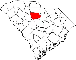 Map of South Carolina highlighting Fairfield County | |
| CDP | ||
| Unincorporated communities | ||
| Ghost town | ||
| Footnotes | ‡This populated place also has portions in an adjacent county or counties | |
| ||
Municipalities and communities of Richland County, South Carolina, United States | ||
|---|---|---|
| Cities | 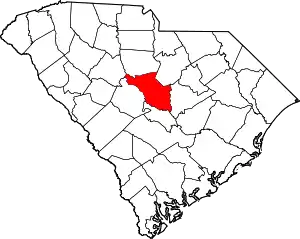 Map of South Carolina highlighting Richland County | |
| Towns | ||
| CDPs | ||
| Unincorporated communities | ||
| Unincorporated community | ||
| Footnotes | ‡This populated place also has portions in an adjacent county or counties | |
| ||