Gadsden, South Carolina
Gadsden is a census-designated place (CDP) in Richland County, South Carolina, United States. The population was 1,632 at the 2010 census.[3] It is part of the Columbia, South Carolina metropolitan area.
Gadsden, South Carolina | |
|---|---|
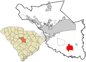 Location in Richland County and the state of South Carolina. | |
| Coordinates: 33°50′44″N 80°45′57″W | |
| Country | United States |
| State | South Carolina |
| County | Richland |
| Area | |
| • Total | 11.5 sq mi (29.8 km2) |
| • Land | 11.5 sq mi (29.8 km2) |
| • Water | 0 sq mi (0 km2) |
| Elevation | 150 ft (50 m) |
| Population (2010) | |
| • Total | 1,632 |
| • Density | 140/sq mi (55/km2) |
| Time zone | UTC-5 (Eastern (EST)) |
| • Summer (DST) | UTC-4 (EDT) |
| ZIP code | 29052 |
| FIPS code | 45-27970[1] |
| GNIS feature ID | 1249488[2] |
History
The John J. Kaminer House, Magnolia, Oakwood, and Richland Presbyterian Church are listed on the National Register of Historic Places.[4]
Geography
Gadsden is located at latitude 33.846 North and longitude 80.766 West. The elevation is 148 feet (45 m) above sea level.[5] According to the U.S. Census Bureau, the CDP has an area of 11.5 square miles (29.8 km2), of which 0.008 square miles (0.02 km2), or 0.06%, is water.[3] The community is located at the intersection of state highways 48 and 769.
References
- "U.S. Census website". United States Census Bureau. Retrieved 2008-01-31.
- "US Board on Geographic Names". United States Geological Survey. 2007-10-25. Retrieved 2008-01-31.
- "Geographic Identifiers: 2010 Demographic Profile Data (G001): Gadsden CDP, South Carolina". U.S. Census Bureau, American Factfinder. Archived from the original on February 12, 2020. Retrieved January 14, 2013.
- "National Register Information System". National Register of Historic Places. National Park Service. July 9, 2010.
- "Gadsden, South Carolina". HomeTownLocator.
Municipalities and communities of Richland County, South Carolina, United States | ||
|---|---|---|
| Cities | 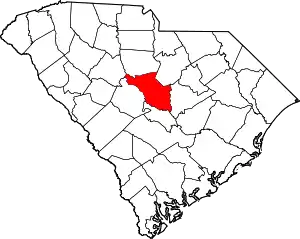 Map of South Carolina highlighting Richland County | |
| Towns | ||
| CDPs | ||
| Unincorporated communities | ||
| Unincorporated community | ||
| Footnotes | ‡This populated place also has portions in an adjacent county or counties | |
| ||
This article is issued from Wikipedia. The text is licensed under Creative Commons - Attribution - Sharealike. Additional terms may apply for the media files.