Borama
Borama (Somali: Boorama, Arabic: بوراما) is the capital and the largest city of the northwestern Awdal region of Somaliland[1] The commercial seat of the province, it is situated near the border with Ethiopia.
Borama
Boorama بوراما | |
|---|---|
City | |
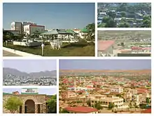
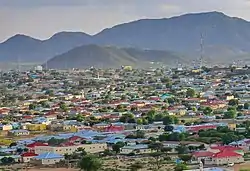 A residential area in Borama | |
 Flag Local council Seal of Borama | |
.svg.png.webp) Borama Location of Borama | |
| Coordinates: 9°56′9″N 43°11′3″E | |
| Country | |
| Region | Awdal |
| District | Borama |
| Government | |
| • Mayor | Suleiman Hassan Haddi |
| Area | |
| • Total | 14 km2 (5 sq mi) |
| Population | |
| • Estimate (2017)[1] | 320,616 |
| Time zone | UTC+3 (EAT) |
| Climate | BSh |
During the Middle Ages, Borama was ruled by the Adal Sultanate. It later formed a part of the British Somaliland protectorate in the first half of the 20th century.
According to the UNDP in 2005, the city had a population of around 215,616, making it one of the largest cities inside Somaliland.[1] It has been a leading example in community organizing, having been the first area in Somaliland to adopt a self-help scheme in the wake of the civil war.[2]
History
As with several nearby towns such as Amud, numerous archaeological finds have been discovered in the Borama area that point to an eventful past. The latter include ancient remains of tombs, houses and mosques, in addition to sherds of Oriental wares, particularly Chinese porcelain. The artefacts and structures date from various historical periods, ranging from the 12th through to the 18th centuries. Most, however, are from the 15th and 16th centuries, a time of great commercial activity in the region that is associated with the medieval Adal Sultanate.[3]
Excavations in the late 1800s and early 1900s at over fourteen sites in the vicinity of Borama unearthed, among other things, coins identified as having been derived from Kait Bey, the eighteenth Burji Mamluk Sultan of Egypt. Most of these finds were sent to the British Museum for preservation shortly after their discovery.[4]
In the first half of the 20th century, Borama formed a part of the British Somaliland protectorate. It was later given district status in 1925.
In 1933, Sheikh Abdurahman Sheikh Nuur, a Qur'anic teacher and son of Borama's qadi (judge), devised a new orthography for transcribing the Afro-Asiatic Cushitic Somali language. A quite accurate phonetic writing system, this Borama script was principally used by Nuur and his circle of associates in the city.[5][6] The alphabet is also generally known as the Gadabuursi script.[7]
During the onset of World War II, the town was captured by the Italians. It was re-captured by the British the following year, in 1940. In the post-independence period, Borama was administered as part of the official Awdal administrative region of Somalia. During the Ogaden War in the late 1970s, Borama was one of several northern cities that was aerially bombarded by Ethiopian forces.[8]
Geography
Location and habitat
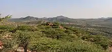
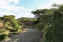
Borama is situated in a mountainous and hilly area. It has green meadows and fields, and represents a key focal point for wildlife. The town's unusual fertility and greenery in the largely arid countryside has attracted many fauna, such as gazelles, birds and camels.
Climate
The prevailing climate in Borama is known as a local steppe climate. The warmest month of the year is June with an average temperature of 24.1 °C. In January, the average temperature is 17.1 °C. It is the lowest average temperature of the whole year and the difference in precipitation between the driest month and the wettest month is 110 mm. The average temperatures vary during the year by 7 °C.[9]
| Climate data for Borama | |||||||||||||
|---|---|---|---|---|---|---|---|---|---|---|---|---|---|
| Month | Jan | Feb | Mar | Apr | May | Jun | Jul | Aug | Sep | Oct | Nov | Dec | Year |
| Average high °C (°F) | 24.6 (76.3) |
25.4 (77.7) |
27.5 (81.5) |
27.8 (82.0) |
29.3 (84.7) |
30.0 (86.0) |
28.8 (83.8) |
28.8 (83.8) |
29.0 (84.2) |
27.4 (81.3) |
25.8 (78.4) |
24.4 (75.9) |
27.4 (81.3) |
| Average low °C (°F) | 9.7 (49.5) |
11.7 (53.1) |
13.8 (56.8) |
15.7 (60.3) |
17.0 (62.6) |
18.3 (64.9) |
17.8 (64.0) |
17.6 (63.7) |
17.3 (63.1) |
13.7 (56.7) |
11.3 (52.3) |
10.4 (50.7) |
14.5 (58.1) |
| Average rainfall mm (inches) | 6 (0.2) |
21 (0.8) |
36 (1.4) |
86 (3.4) |
61 (2.4) |
32 (1.3) |
78 (3.1) |
112 (4.4) |
86 (3.4) |
18 (0.7) |
10 (0.4) |
2 (0.1) |
548 (21.6) |
| Source: Climate-Data.org,[9] altitude: 1454m[10] | |||||||||||||
Demographics
As of 2005, Borama had a population of around 215,616 inhabitants.[1] The Awdal region in which the city is situated is inhabited by people from the Somali ethnic group, with the Gadabuursi subclan of the Dir especially well represented and considered the predominant clan of the region.[11]
Federico Battera (2005) states about the Awdal Region:
"Awdal is mainly inhabited by the Gadabuursi confederation of clans."[12]
A UN Report published by Canada: Immigration and Refugee Board of Canada (1999), states concerning Awdal:
"The Gadabuursi clan dominates Awdal region. As a result, regional politics in Awdal is almost synonymous with Gadabuursi internal clan affairs."[13]
Roland Marchal (1997) states that numerically, the Gadabuursi are the predominant inhabitants of the Awdal Region:
"The Gadabuursi's numerical predominance in Awdal virtually ensures that Gadabuursi interests drive the politics of the region."[14]
Marleen Renders and Ulf Terlinden (2010) both state that the Gadabuursi almost exclusively inhabit the Awdal Region:
"Awdal in western Somaliland is situated between Djibouti, Ethiopia and the Issaq-populated mainland of Somaliland. It is primarily inhabited by the three sub-clans of the Gadabursi clan, whose traditional institutions survived the colonial period, Somali statehood and the war in good shape, remaining functionally intact and highly relevant to public security."[15]
There is also a sizeable minority of the Issa subclan of the Dir who mainly inhabit the Zeila district.[16]
Education
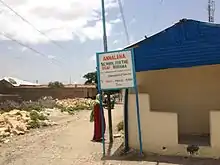
Currently, there are 52 primary and secondary schools in Borama. These schools can be divided into three main categories: public primary and secondary schools, private primary and secondary schools and Religious schools.
Total number of students in Borama is 15,314.[17]
Transportation
For air transportation, Borama is served by the Borama International Airport.[18] It is the only airport in the Awdal region. The facility was named in honor of Aden Isaaq, Somalia's first Minister of Education. The airport is not in use; however, there are plans to rejuvenate it.[19]
Notable residents
- Yussur A.F. Abrar – former Governor of the Central Bank of Somalia
- Hassan Sheikh Mumin - Somali poet, playwright, broadcaster, actor and composer.
- Suleiman Ahmed Guleid - President Of Amoud University
- Sh. Abdillahi Sh.Ali Jawhar - Son of Sh. Ali jawhar and religious leader
See also
Notes
- "Somalia City & Town Population" (PDF). FAO. Archived from the original (PDF) on 11 February 2015. Retrieved 20 October 2015.
- Borama Local Council, p.10.
- Bernard Samuel Myers, ed., Encyclopedia of World Art, Volume 13, (McGraw-Hill: 1959), p.xcii.
- Royal Geographical Society (Great Britain), The Geographical Journal, Volume 87, (Royal Geographical Society: 1936), p.301.
- David D. Laitin, Politics, Language, and Thought: The Somali Experience, (University Of Chicago Press: 1977), pp.86-87.
- I.M. Lewis (1958), The Gadabuursi Somali Script, Bulletin of the School of Oriental and African Studies, University of London, Vol. 21, pp. 134–156.
- "Somali alphabets, pronunciation and language". Omniglot. Retrieved 3 January 2015.
- Mohamoud, Abdulkadir. "The Night SNM Fighters came to Hargeisa". Warheernews. Archived from the original on 28 May 2012. Retrieved 3 January 2015.
- "Climate: Borama - Climate graph, Temperature graph, Climate table". Climate-Data.org. Retrieved 25 September 2013.
- "Land Resources Assessment of Somalia" (PDF). Somalia Water and Land Information Management Project. June 2009. p. 10. Archived from the original (PDF) on October 5, 2013. Retrieved October 1, 2013.
- Samatar, Abdi I. (2001) "Somali Reconstruction and Local Initiative: Amoud University," Bildhaan: An International Journal of Somali Studies: Vol. 1, Article 9, p. 132.
- Battera, Federico (2005). "Chapter 9: The Collapse of the State and the Resurgence of Customary Law in Northern Somalia". Shattering Tradition: Custom, Law and the Individual in the Muslim Mediterranean. Walter Dostal, Wolfgang Kraus (ed.). London: I.B. Taurus. p. 296. ISBN 1-85043-634-7. Retrieved 2010-03-18.
Awdal is mainly inhabited by the Gadabuursi confederation of clans.
- UN (1999) Somaliland: Update to SML26165.E of 14 February 1997 on the situation in Zeila, including who is controlling it, whether there is fighting in the area, and whether refugees are returning. "Gadabuursi clan dominates Awdal region. As a result, regional politics in Awdal is almost synonymous with Gadabuursi internal clan affairs." p. 5.
- Marchal, Roland (1997). "United Nations Development Office for Somalia: Studies on Governance: Awdal Region".
The Gadabuursi's numerical predominance in Awdal virtually ensures that Gadabuursi interests drive the politics of the region.
- Renders, Marleen; Terlinden, Ulf. "Chapter 9: Negotiating Statehood in a Hybrid Political Order: The Case of Somaliland". In Tobias Hagmann; Didier Péclard (eds.). Negotiating Statehood: Dynamics of Power and Domination in Africa (PDF). p. 191. Retrieved 2012-01-21.
Awdal in western Somaliland is situated between Djibouti, Ethiopia and the Issaq-populated mainland of Somaliland. It is primarily inhabited by the three sub-clans of the Gadabursi clan, whose traditional institutions survived the colonial period, Somali statehood and the war in good shape, remaining functionally intact and highly relevant to public security.
- Janzen, J.; von Vitzthum, S.; Somali Studies International Association (2001). What are Somalia's Development Perspectives?: Science Between Resignation and Hope? : Proceedings of the 6th SSIA Congress, Berlin 6-9 December 1996. Proceedings of the ... SSIA-Congress. Das Arabische Buch. p. 132. ISBN 978-3-86093-230-8. Archived from the original on 20 July 2018. Retrieved 20 July 2018.
- "2011/2 Primary School Census Statistics Yearbook" (PDF).
- "Borama International Airport". Altius Directory. Retrieved 31 August 2013.
- "Archived copy". Archived from the original on 2015-04-03. Retrieved 2015-01-05.CS1 maint: archived copy as title (link)
References
| Wikimedia Commons has media related to Borama. |
- Borama Local Council. Economic and Project Management Committee (2003). The Statistical Abstract of Borama Municipality: Borama, Regional Capital of Awdal (PDF). Borama Local Council.
