Boundary Butte
Boundary Butte is a 4,934-foot (1,504 meter) elevation sandstone summit located south of Lake Powell, in San Juan County of southern Utah.[1] It is situated on Navajo Nation land, 11.5 miles (18.5 km) northeast of the town of Page, and towers 1,200 feet above the lake as a landmark of the area. It lies on the Utah-Arizona border, hence its name.
| Boundary Butte | |
|---|---|
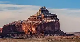 Northwest aspect | |
| Highest point | |
| Elevation | 4,934 ft (1,504 m) [1] |
| Prominence | 897 ft (273 m) [2] |
| Parent peak | Tower Butte[2] |
| Isolation | 2.58 mi (4.15 km) [2] |
| Coordinates | 37°00′05″N 111°17′13″W [1] |
| Geography | |
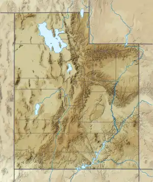 Boundary Butte Location in Utah  Boundary Butte Boundary Butte (the United States) | |
| Location | Navajo Reservation San Juan County, Utah, U.S. |
| Parent range | Colorado Plateau |
| Topo map | USGS Gunsight Butte |
| Geology | |
| Age of rock | Jurassic |
| Type of rock | Entrada Sandstone |
| Climbing | |
| Easiest route | class 5.x climbing[2] |
Geology
Boundary Butte is a butte composed primarily of Entrada Sandstone, similar to Dominguez Butte 2.5 miles (4.0 km) to the north, and Tower Butte 2.6 miles (4.2 km) to the southwest. The Entrada Sandstone overlays Carmel Formation, and below that Page Sandstone at lake level. Above the Entrada layers is Romana Sandstone capped by Morrison Formation.[3] It is located in the southern edge of the Great Basin Desert on the Colorado Plateau. Precipitation runoff from this feature drains into the Colorado River watershed.
Gallery
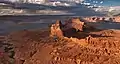 Aerial view looking north, with Boundary Butte centered
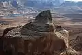 Aerial view of west aspect
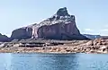 From northwest
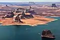 Aerial view looking south. Dominguez Butte left of center, nearest to water's edge.
Boundary Butte behind right. (Tower Butte upper right corner. Padres Butte in lower right corner. LeChee Rock centered on horizon).jpg.webp) Boundary Butte to the right
Boundary Butte to the right
Climate
According to the Köppen climate classification system, Boundary Butte is located in an arid climate zone with hot, very dry summers, and chilly winters with very little snow.[4] Spring and fall are the most favorable seasons to visit.
| Climate data for Page, Arizona | |||||||||||||
|---|---|---|---|---|---|---|---|---|---|---|---|---|---|
| Month | Jan | Feb | Mar | Apr | May | Jun | Jul | Aug | Sep | Oct | Nov | Dec | Year |
| Record high °F (°C) | 64 (18) |
72 (22) |
82 (28) |
91 (33) |
102 (39) |
107 (42) |
109 (43) |
106 (41) |
100 (38) |
93 (34) |
77 (25) |
66 (19) |
109 (43) |
| Average high °F (°C) | 43.1 (6.2) |
50.3 (10.2) |
59.5 (15.3) |
68.5 (20.3) |
78.5 (25.8) |
90.2 (32.3) |
95.1 (35.1) |
92.0 (33.3) |
83.5 (28.6) |
69.7 (20.9) |
53.8 (12.1) |
43.7 (6.5) |
69.0 (20.6) |
| Average low °F (°C) | 26.3 (−3.2) |
30.4 (−0.9) |
37.0 (2.8) |
43.6 (6.4) |
52.6 (11.4) |
62.3 (16.8) |
68.3 (20.2) |
66.4 (19.1) |
58.4 (14.7) |
46.6 (8.1) |
34.7 (1.5) |
27.1 (−2.7) |
46.1 (7.8) |
| Record low °F (°C) | −11 (−24) |
6 (−14) |
18 (−8) |
25 (−4) |
31 (−1) |
44 (7) |
56 (13) |
46 (8) |
40 (4) |
24 (−4) |
16 (−9) |
1 (−17) |
−11 (−24) |
| Average precipitation inches (mm) | 0.61 (15) |
0.48 (12) |
0.65 (17) |
0.50 (13) |
0.40 (10) |
0.14 (3.6) |
0.58 (15) |
0.69 (18) |
0.66 (17) |
0.99 (25) |
0.56 (14) |
0.48 (12) |
6.74 (171.6) |
| Average snowfall inches (cm) | 2.1 (5.3) |
1.2 (3.0) |
0.2 (0.51) |
0 (0) |
0 (0) |
0 (0) |
0 (0) |
0 (0) |
0 (0) |
0 (0) |
0.5 (1.3) |
1.4 (3.6) |
5.4 (13.71) |
| Average precipitation days (≥ 0.01 in) | 4.5 | 4.0 | 5.2 | 3.5 | 3.2 | 1.7 | 4.6 | 5.2 | 4.5 | 4.3 | 3.2 | 3.9 | 47.8 |
| Average snowy days (≥ 0.1 in) | 0.9 | 0.6 | 0.3 | 0 | 0 | 0 | 0 | 0 | 0 | 0 | 0.2 | 0.6 | 2.6 |
| Source: NOAA[5] | |||||||||||||
References
- "Boundary Butte". Geographic Names Information System. United States Geological Survey. Retrieved 2020-11-18.
- "Boundary Butte - 4,997' UT". listsofjohn.com. Retrieved 2020-11-18.
- T.C. Chidsey, Jr., D.A. Sprinkel, G.C. Willis, P.B. Anderson Lake Powell Geologic Guide, page 63.
- Peel, M. C.; Finlayson, B. L.; McMahon, T. A. (2007). "Updated world map of the Köppen−Geiger climate classification". Hydrol. Earth Syst. Sci. 11. ISSN 1027-5606.
- "Climatography of the United States No. 20 (1971–2000)" (PDF). National Oceanic and Atmospheric Administration. 2004. Retrieved 2010-05-31.
External links
- Weather forecast: National Weather Service