Bremer Bay, Western Australia
Bremer Bay is a coastal town situated on the south coast of Western Australia in the Great Southern region between Albany and Esperance, at the mouth of the Bremer River. Bremer Bay is 515 kilometres (320 mi) southeast of the state capital, Perth, and 180 kilometres (112 mi) east of Albany.[2]
| Bremer Bay Western Australia | |||||||||
|---|---|---|---|---|---|---|---|---|---|
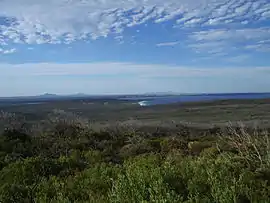 View of Bremer Bay | |||||||||
 Bremer Bay | |||||||||
| Coordinates | 34.394°S 119.376°E | ||||||||
| Population | 231 (2016 census)[1] | ||||||||
| Postcode(s) | 6338 | ||||||||
| Elevation | 27 m (89 ft) | ||||||||
| Location | |||||||||
| LGA(s) | Shire of Jerramungup | ||||||||
| State electorate(s) | Roe | ||||||||
| Federal Division(s) | O'Connor | ||||||||
| |||||||||
Demographics
In 2016 the townsite had a population of 231.[1] Over the 2018 Christmas and New Year holiday period the town's population reached almost 6,500.[3]
History
The bay was named by John Septimus Roe, who visited the area in 1831, after Sir James Bremer, captain of HMS Tamar, under whom he served as a lieutenant from 1824 to 1827.[4][5]
The area was originally settled in the 1850s with the first homestead, the Wellstead homestead being built in 1857 and the first telegraph station being built in 1875. A second telegraph station was built of stone in 1896 to replace the first one.[6]
The town was originally included in the township of Wellstead until a local petition in 1951 favoured a change to the current name, which was approved and gazetted in 1962.[7]
In 2012, the town was menaced by a bushfire that burnt for five days after being started by lightning. The fire burnt out 10,000 hectares (25,000 acres) of farmland and bushland, requiring 120 fire-fighters to bring it under control just outside the town.[8]
Amenities
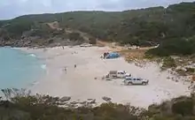
Bremer Bay is known for its beautiful beaches; the main beach is only 10 minutes walk from town. A marina at Fishery Beach offers full boating facilities.[9] The Bremer Marine Park lies offshore. Electricity is generated by a wind-diesel hybrid system.
References
- Australian Bureau of Statistics (27 June 2017). "Bremer Bay (Urban Centre/Locality)". 2016 Census QuickStats. Retrieved 1 December 2018.

- "Great Southern Regional Portal Bremer Bay". 2006. Retrieved 30 May 2007.
- Smith, Shannon (4 January 2019). "New Years celebrators trash Bremer Bay". Albany Advertiser. Retrieved 17 January 2019.
- Jackson, Janice Lynne Burton (1982). Not an Idle Man: A Biography of John Septimus Roe. Western Australia's First Surveyor-general, 1797–1878. West Swan, W.A.: M.B. Roe.
- Uren, Malcolm (1967). "Roe, John Septimus (1797–1878)". Australian Dictionary of Biography. Melbourne University Press. Retrieved 17 January 2019.
- "Shire of Jerramungup – Municipal Inventory". Shire of Jerramungup. Archived from the original on 17 March 2015. Retrieved 30 August 2015.
- Western Australian Land Information Authority. "History of country town names – B". Retrieved 30 May 2007.
- "Bremer Bay residents warned of worst case scenario". Australian Broadcasting Corporation. 3 December 2012. Retrieved 25 March 2013.
- "Bremer Bay, Western Australia Webpage". 2006. Archived from the original on 16 May 2007. Retrieved 30 May 2007.