Shire of Jerramungup
The Shire of Jerramungup is a local government area in the Great Southern region of Western Australia, about 180 kilometres (112 mi) northeast of Albany and about 440 kilometres (273 mi) southeast of the state capital, Perth. The Shire covers an area of 6,507 square kilometres (2,512 sq mi) with Bremer Bay its largest town. The seat of government is the town of Jerramungup.
| Shire of Jerramungup Western Australia | |||||||||||||||
|---|---|---|---|---|---|---|---|---|---|---|---|---|---|---|---|
.jpg.webp) Administration Centre | |||||||||||||||
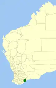 Location in Western Australia | |||||||||||||||
| Population | 1,109 (2016 census)[1] | ||||||||||||||
| • Density | 0.17043/km2 (0.44141/sq mi) | ||||||||||||||
| Established | 1982 | ||||||||||||||
| Area | 6,507.1 km2 (2,512.4 sq mi) | ||||||||||||||
| Shire President | Robert Lester | ||||||||||||||
| Council seat | Jerramungup | ||||||||||||||
| Region | Great Southern | ||||||||||||||
| State electorate(s) | Roe | ||||||||||||||
| Federal Division(s) | O'Connor | ||||||||||||||
 | |||||||||||||||
| Website | Shire of Jerramungup | ||||||||||||||
| |||||||||||||||
The Fitzgerald River National Park, within the Shire, covers an area of 2,972 square kilometres (1,147 sq mi). The park is one of the most botanically significant national parks in Australia, containing 20% of Western Australia's described plant species - more than 1,800 in total.[2]
History
The Shire of Jerramungup was established on 1 July 1982. It previously comprised the eastern half of the Shire of Gnowangerup.[3]
Wards
As of the 2003 elections, the shire is not divided into wards, and its 7 councillors sit at large.
Towns and localities
References
- Australian Bureau of Statistics (27 June 2017). "Jerramungup (S)". 2016 Census QuickStats. Retrieved 26 November 2017.

- "Fitzgerald River National Park". Kensington WA: Parks and Wildlife Service. Retrieved 5 February 2021.
- WA Electoral Commission, Municipality Boundary Amendments Register (release 2.0), 31 May 2003.