Brockton, Ontario
Brockton is a town in the Canadian province of Ontario, located in Bruce County. As of 2016, the population was 9,461.[1]
Brockton | |
|---|---|
| Municipality of Brockton | |
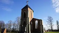 St. Michael Church remains, Brant | |
 Brockton Location in southern Ontario | |
| Coordinates: 44°10′N 81°13′W | |
| Country | Canada |
| Province | Ontario |
| County | Bruce |
| Settled | 1848 |
| Formed | January 1, 1999 |
| Government | |
| • Mayor | Chris Peabody |
| • Federal riding | Huron—Bruce |
| • Prov. riding | Huron—Bruce |
| Area | |
| • Land | 565.18 km2 (218.22 sq mi) |
| Population (2016)[1] | |
| • Total | 9,461 |
| • Density | 16.7/km2 (43/sq mi) |
| Time zone | UTC−05:00 (EST) |
| • Summer (DST) | UTC−04:00 (EDT) |
| Postal Code FSA | N0G |
| Area code(s) | 519 and 226 |
| Website | www |
The current municipality was formed on January 1, 1999, by amalgamating the former township of Brant, former township of Greenock and the town of Walkerton. Brockton's name was formed as a portmanteau of the three merged municipalities (Brant Greenock Walkerton).
Communities
Communities in the Municipality of Brockton include the former town of Walkerton and the villages within the boundaries of the two former Brant and Greenock Townships: Bradley, Cargill, Chepstow, Dunkeld, Eden Grove, Glammis, Greenock, Little Egypt, Malcolm, Maple Hill, Narva, Marle Lake, Lake Rosalind, Pearl Lake, Pinkerton, Portal, Riversdale and Solway.
Mayors
- David Thomson (1999-2003)
- Charlie Bagnato (2003-2010)
- David Inglis (2010–2018)
- Chris Peabody (2018-present)
Demographics
| Canada census – Brockton, Ontario community profile | |||
|---|---|---|---|
| 2016 | 2011 | 2006 | |
| Population: | 9,461 (+0.3% from 2011) | 9,432 (-2.2% from 2006) | 9,641 (-0.2% from 2001) |
| Land area: | 565.18 km2 (218.22 sq mi) | 565.41 km2 (218.31 sq mi) | 565.07 km2 (218.17 sq mi) |
| Population density: | 16.7/km2 (43/sq mi) | 16.7/km2 (43/sq mi) | 17.1/km2 (44/sq mi) |
| Median age: | 46.2 (M: 45.0, F: 47.5) | 45.0 (M: 44.4, F: 45.5) | 42.5 (M: 41.6, F: 43.2) |
| Total private dwellings: | 4,252 | 4,157 | 4,064 |
| Median household income: | $67,597 | $55,232 | |
| References: 2016[2] 2011[3] 2006[4] earlier[5] | |||
Mother tongue:[4]
- English as first language: 95.2%
- French as first language: 0.2%
- English and French as first language: 0%
- Other as first language: 4.5%
- Population in 2016: 9,461
- Population in 2011: 9,432
- Population in 2006: 9,641
- Population in 2001: 9,658
- Population total in 1996: 10,163
- Brant (township): 3,455
- Greenock (township): 1,672
- Walkerton (town): 5,036
- Population in 1991:
- Brant (township): 3,420
- Greenock (township): 1,741
- Walkerton (town): 4,939
References
- "Census Profile, 2016 Census: Brockton, Municipality". Statistics Canada. Retrieved June 10, 2019.
- "2016 Community Profiles". 2016 Canadian Census. Statistics Canada. February 21, 2017. Retrieved 2019-06-10.
- "2011 Community Profiles". 2011 Canadian Census. Statistics Canada. July 5, 2013. Retrieved 2012-08-09.
- "2006 Community Profiles". 2006 Canadian Census. Statistics Canada. March 30, 2011. Retrieved 2012-08-09.
- "2001 Community Profiles". 2001 Canadian Census. Statistics Canada. February 17, 2012.
- Statistics Canada: 1996, 2001, 2006 census
- "Brockton census profile". 2011 Census of Population. Statistics Canada. Retrieved 2012-08-09.
External links
| Wikimedia Commons has media related to Brockton, Ontario. |
 Brockton, Ontario travel guide from Wikivoyage
- Official website
Places adjacent to Brockton, Ontario | |
|---|---|