Brookfield, Vermont
Brookfield is a town in Orange County, Vermont, United States. It was created by Vermont charter on August 5, 1781. The population was 1,292 at the 2010 census. Brookfield is best known for its floating bridge which spans Sunset Lake buoyed by pontoons. The bridge, which is the only floating bridge east of the Mississippi River, was originally built in 1820 by Luther Adams and his neighbors. Sunset Lake is also the site of an annual ice harvesting festival. Brookfield boasts that it has Vermont's oldest continually operating library dating back to 1791. In 2006, Brookfield was one of the first American towns to have its citizens pass a resolution endorsing the impeachment of President George W. Bush. As of September 2010, the floating bridge was closed for repairs. Work began in 2014, and was completed May 2015. There was a celebration from May 23–24, 2015, to memorialize the event. Governor Peter Shumlin attended, and cadets from Norwich University provided traffic control.
Brookfield, Vermont | |
|---|---|
Town | |
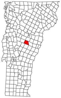 Located in Orange County, Vermont | |
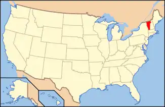 Location of Vermont with the U.S.A. | |
| Coordinates: 44°1′25″N 72°36′0″W | |
| Country | United States |
| State | Vermont |
| County | Orange |
| Chartered | 1781 |
| Settled | 1779 |
| Organized | 1785 |
| Communities | Brookfield Brookfield Center East Brookfield West Brookfield |
| Area | |
| • Total | 41.7 sq mi (107.9 km2) |
| • Land | 41.4 sq mi (107.2 km2) |
| • Water | 0.3 sq mi (0.7 km2) |
| Elevation | 1,325 ft (333 m) |
| Population (2000) | |
| • Total | 1,222 |
| • Density | 29.5/sq mi (11.4/km2) |
| • Households | 475 |
| • Families | 351 |
| Time zone | UTC-5 (EST) |
| • Summer (DST) | UTC-4 (EDT) |
| ZIP code | 05036 |
| Area code(s) | 802 |
| FIPS code | 50-09325[1] |
| GNIS feature ID | 1462054[2] |
| Website | brookfieldvt.org |
The town's modest village center is listed on the National Register of Historic Places as the Brookfield Village Historic District.
Geography
According to the United States Census Bureau, the town has a total area of 41.7 square miles (107.9 km2), of which 41.4 square miles (107.2 km2) is land and 0.3 square mile (0.7 km2) (0.65%) is water.
Demographics
| Historical population | |||
|---|---|---|---|
| Census | Pop. | %± | |
| 1790 | 419 | — | |
| 1800 | 988 | 135.8% | |
| 1810 | 1,384 | 40.1% | |
| 1820 | 1,507 | 8.9% | |
| 1830 | 1,677 | 11.3% | |
| 1840 | 1,789 | 6.7% | |
| 1850 | 1,672 | −6.5% | |
| 1860 | 1,521 | −9.0% | |
| 1870 | 1,269 | −16.6% | |
| 1880 | 1,239 | −2.4% | |
| 1890 | 996 | −19.6% | |
| 1900 | 996 | 0.0% | |
| 1910 | 1,008 | 1.2% | |
| 1920 | 860 | −14.7% | |
| 1930 | 761 | −11.5% | |
| 1940 | 808 | 6.2% | |
| 1950 | 762 | −5.7% | |
| 1960 | 597 | −21.7% | |
| 1970 | 606 | 1.5% | |
| 1980 | 959 | 58.3% | |
| 1990 | 1,089 | 13.6% | |
| 2000 | 1,222 | 12.2% | |
| 2010 | 1,292 | 5.7% | |
| 2014 (est.) | 1,289 | [3] | −0.2% |
| U.S. Decennial Census[4] | |||
As of the census[1] of 2000, there were 1,222 people, 475 households, and 351 families residing in the town. The population density was 29.5 people per square mile (11.4/km2). There were 602 housing units at an average density of 14.5 per square mile (5.6/km2). The racial makeup of the town was 97.63% White, 0.16% African American, 0.16% Native American, 0.98% Asian, and 1.06% from two or more races. Hispanic or Latino of any race were 0.08% of the population.
There were 475 households, out of which 32.2% had children under the age of 18 living with them, 61.3% were married couples living together, 9.1% had a female householder with no husband present, and 26.1% were non-families. 17.9% of all households were made up of individuals, and 6.9% had someone living alone who was 65 years of age or older. The average household size was 2.57 and the average family size was 2.87.
In the town, the population was spread out, with 25.1% under the age of 18, 5.6% from 18 to 24, 27.9% from 25 to 44, 30.0% from 45 to 64, and 11.4% who were 65 years of age or older. The median age was 40 years. For every 100 females, there were 100.7 males. For every 100 females age 18 and over, there were 96.4 males.
The median income for a household in the town was $45,515, and the median income for a family was $51,071. Males had a median income of $34,464 versus $24,258 for females. The per capita income for the town was $21,502. About 2.5% of families and 6.1% of the population were below the poverty line, including 6.9% of those under age 18 and 5.3% of those age 65 or over.
Notable people
- Donald M. Hooper (born 1945), Secretary of State of Vermont[5]
- Myron W. Reed (1836-1899), Congregationalist minister and political activist.[6]
References
- "U.S. Census website". United States Census Bureau. Retrieved 2008-01-31.
- "US Board on Geographic Names". United States Geological Survey. 2007-10-25. Retrieved 2008-01-31.
- "Annual Estimates of the Resident Population for Incorporated Places: April 1, 2010 to July 1, 2014". Archived from the original on 2015-05-23. Retrieved June 4, 2015.
- "U.S. Decennial Census". United States Census Bureau. Retrieved May 16, 2015.
-
- "Biography, Donald M. Hooper" (PDF). Vermont State Archives. Montpelier, VT: Vermont Secretary of State. Retrieved January 18, 2017.
- "Myron W. Reed is Dead," Chicago Chronicle, Jan. 31, 1899, unspecified page. Copy preserved in The Papers of Eugene V. Debs, 1834-1945 microfilm edition, reel 9.
External links
- http://www.virtualvermont.com/towns/brookfield.html
- http://www.travel-vermont.net/2008/05/brookfield-and-its-floating-bridge/
Municipalities and communities of Orange County, Vermont, United States | ||
|---|---|---|
| Towns | 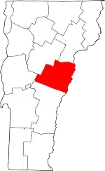 Map of Vermont highlighting Orange County | |
| Villages | ||
| CDPs | ||
| Other communities | ||
| ||
Places adjacent to Brookfield, Vermont | ||||||||||
|---|---|---|---|---|---|---|---|---|---|---|
| ||||||||||
| Authority control |
|---|
