Orange County, Vermont
Orange County is a county located in the U.S. state of Vermont. As of the 2010 census, the population was 28,936.[2] Its shire town (county seat) is the town of Chelsea.[3] Orange County was organized on February 2, 1781 as an original county within the state.
Orange County | |
|---|---|
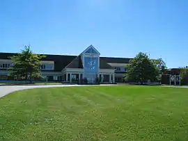
 Orange County Superior Court in Chelsea | |
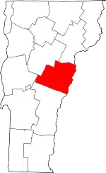 Location within the U.S. state of Vermont | |
 Vermont's location within the U.S. | |
| Coordinates: 43°59′45″N 72°22′30″W | |
| Country | |
| State | |
| Founded | 1781 |
| Named for | William of Orange (William III of England)[1] |
| Shire Town | Chelsea |
| Largest town | Randolph |
| Area | |
| • Total | 692 sq mi (1,790 km2) |
| • Land | 687 sq mi (1,780 km2) |
| • Water | 5.2 sq mi (13 km2) 0.8%% |
| Population (2010) | |
| • Total | 28,936 |
| • Estimate (2019) | 28,892 |
| • Density | 42/sq mi (16/km2) |
| Time zone | UTC−5 (Eastern) |
| • Summer (DST) | UTC−4 (EDT) |
| Congressional district | At-large |
Geography
According to the U.S. Census Bureau, the county has an area of 692 square miles (1,790 km2), of which 687 square miles (1,780 km2) is land and 5.2 square miles (13 km2) (0.8%) is water.[4]
Adjacent counties
- Caledonia County – northeast
- Grafton County, New Hampshire – east
- Windsor County – southwest
- Addison County – west
- Washington County – northwest
Demographics
| Historical population | |||
|---|---|---|---|
| Census | Pop. | %± | |
| 1790 | 10,526 | — | |
| 1800 | 18,238 | 73.3% | |
| 1810 | 25,247 | 38.4% | |
| 1820 | 24,681 | −2.2% | |
| 1830 | 27,285 | 10.6% | |
| 1840 | 27,873 | 2.2% | |
| 1850 | 27,296 | −2.1% | |
| 1860 | 25,455 | −6.7% | |
| 1870 | 23,090 | −9.3% | |
| 1880 | 23,525 | 1.9% | |
| 1890 | 19,575 | −16.8% | |
| 1900 | 19,313 | −1.3% | |
| 1910 | 18,703 | −3.2% | |
| 1920 | 17,279 | −7.6% | |
| 1930 | 16,694 | −3.4% | |
| 1940 | 17,048 | 2.1% | |
| 1950 | 17,027 | −0.1% | |
| 1960 | 16,014 | −5.9% | |
| 1970 | 17,676 | 10.4% | |
| 1980 | 22,739 | 28.6% | |
| 1990 | 26,149 | 15.0% | |
| 2000 | 28,226 | 7.9% | |
| 2010 | 28,936 | 2.5% | |
| 2019 (est.) | 28,892 | [5] | −0.2% |
| U.S. Decennial Census[6] 1790–1960[7] 1900–1990[8] 1990–2000[9] 2010–2018[2] | |||
2000 census
As of the census[10] of 2000, the county had 28,226 people, 10,936 households, and 7,611 families. The population density was 41 people per square mile (16/km2). There were 13,386 housing units at an average density of 19 per square mile (8/km2).
The county's racial makeup was 98.02% White, 0.24% Black or African American, 0.27% Native American, 0.35% Asian, 0.04% Pacific Islander, 0.13% from other races, and 0.95% from two or more races. 0.58% of the population were Hispanic or Latino of any race. 24.3% were of English, 12.8% French, 11.5% American, 10.8% Irish, 6.0% German and 5.5% French Canadian ancestry. 97.4% spoke English and 1.5% French as their first language.
There were 10,936 households, of which 33.40% had children under the age of 18 living with them, 56.10% were married couples living together, 8.90% had a female householder with no husband present, and 30.40% were non-families. 23.40% of all households were made up of individuals, and 9.20% had someone living alone who was 65 years of age or older. The average household size was 2.52 and the average family size was 2.97.
25.60% of the county's population was under age 18, 7.80% was from age 18 to 24, 28.20% was from age 25 to 44, 25.60% was from age 45 to 64, and 12.80% was age 65 or older.
The median age was 39 years. For every 100 females, there were 99.20 males. For every 100 females age 18 and over, there were 96.60 males.
The county's median household income was $39,855, and the median family income was $45,771. Males had a median income of $30,679 versus $24,144 for females. The county's per capita income was $18,784. About 6.10% of families and 9.10% of the population were below the poverty line, including 11.40% of those under age 18 and 8.80% of those age 65 or over.
2010 census
As of the 2010 United States Census, the county had 28,936 people, 11,887 households, and 7,865 families.[11] The population density was 42.1 inhabitants per square mile (16.3/km2). There were 14,845 housing units at an average density of 21.6 per square mile (8.3/km2).[12]
The county's racial makeup was 97.0% white, 0.5% Asian, 0.4% black or African American, 0.3% American Indian, 0.3% from other races, and 1.5% from two or more races. Those of Hispanic or Latino origin made up 1.0% of the population.[11] The largest ancestry groups were English (22.4%), Irish (16.5%); French (14.7%), German (10.4%), "American" (7.3%), French Canadian (7.1%), Italian (6.5%); Scottish (6.5%).[13]
Of the 11,887 households, 28.3% had children under age 18 living with them, 51.9% were married couples living together, 9.3% had a female householder with no husband present, 33.8% were non-families, and 25.9% of all households were made up of individuals. The average household size was 2.37 and the average family size was 2.83. The median age was 43.8 years.[11]
The county's median household income was $52,079 and the median family income was $61,221. Males had a median income of $41,281 versus $35,938 for females. The county's per capita income was $25,951. About 6.2% of families and 10.0% of the population were below the poverty line, including 13.2% of those under age 18 and 7.2% of those age 65 or over.[14]
Politics
In 1828, Orange County was won by National Republican Party candidate John Quincy Adams.
In 1832, the county was won by Anti-Masonic Party candidate William Wirt.
From William Henry Harrison in 1836 to Winfield Scott in 1852, the county would vote the Whig Party candidates.
From John C. Frémont in 1856 to Richard Nixon in 1960 (barring 1912, where the county was won by Progressive Party candidate and former president Theodore Roosevelt), the Republican Party would have a 104-year winning streak in the county.
In 1964, the county was won by Democratic Party incumbent President Lyndon B. Johnson, who became not only the first Democratic presidential candidate to win Orange County, but the first to win the state of Vermont entirely.
Following the Democrats victory in 1964, the county went back to voting for Republican candidates for another 20 year winning streak starting with Richard Nixon in 1968 and ending with George H. W. Bush in 1988.
The county would be won by Bill Clinton in both the 1992 and 1996 presidential elections.
George W. Bush would win Orange County in 2000 and would be the last time a Republican presidential candidate would carry the county.
John Kerry won the county in 2004 and has been won by Democratic candidates ever since.
| Year | Republican | Democratic | Third parties |
|---|---|---|---|
| 2020 | 36.1% 6,187 | 60.2% 10,304 | 3.7% 631 |
| 2016 | 34.2% 5,007 | 51.5% 7,541 | 14.3% 2,101 |
| 2012 | 32.7% 4,588 | 64.6% 9,076 | 2.8% 389 |
| 2008 | 33.3% 5,047 | 64.6% 9,799 | 2.2% 333 |
| 2004 | 43.1% 6,421 | 54.8% 8,159 | 2.1% 315 |
| 2000 | 46.7% 6,858 | 45.6% 6,694 | 7.8% 1,143 |
| 1996 | 33.0% 4,043 | 49.8% 6,107 | 17.3% 2,116 |
| 1992 | 31.7% 4,249 | 43.1% 5,774 | 25.3% 3,387 |
| 1988 | 54.4% 6,151 | 44.0% 4,977 | 1.7% 190 |
| 1984 | 60.2% 6,407 | 38.4% 4,088 | 1.3% 140 |
| 1980 | 49.5% 4,656 | 32.8% 3,079 | 17.7% 1,667 |
| 1976 | 58.6% 4,768 | 39.0% 3,171 | 2.4% 196 |
| 1972 | 69.1% 5,389 | 29.9% 2,332 | 1.0% 76 |
| 1968 | 66.2% 4,135 | 30.1% 1,879 | 3.8% 236 |
| 1964 | 41.0% 2,723 | 59.0% 3,918 | 0.0% 1 |
| 1960 | 77.2% 5,363 | 22.8% 1,581 | |
| 1956 | 84.0% 5,616 | 16.0% 1,072 | 0.0% 2 |
| 1952 | 83.5% 5,610 | 16.1% 1,082 | 0.4% 27 |
| 1948 | 77.0% 4,061 | 21.6% 1,139 | 1.4% 76 |
| 1944 | 73.8% 4,117 | 26.2% 1,464 | |
| 1940 | 68.8% 4,527 | 30.8% 2,029 | 0.4% 23 |
| 1936 | 73.3% 4,956 | 26.6% 1,796 | 0.2% 11 |
| 1932 | 69.3% 4,305 | 29.5% 1,830 | 1.2% 77 |
| 1928 | 84.7% 5,223 | 14.8% 914 | 0.5% 30 |
| 1924 | 82.9% 4,657 | 12.9% 724 | 4.3% 240 |
| 1920 | 78.9% 3,713 | 19.9% 938 | 1.1% 53 |
| 1916 | 59.3% 2,151 | 38.0% 1,379 | 2.7% 97 |
| 1912 | 34.2% 1,289 | 25.4% 956 | 40.5% 1,525 |
| 1908 | 74.5% 2,262 | 22.0% 667 | 3.6% 109 |
| 1904 | 77.1% 2,259 | 20.0% 587 | 2.8% 83 |
| 1900 | 75.3% 2,515 | 22.2% 740 | 2.5% 84 |
| 1896 | 80.2% 3,067 | 14.8% 567 | 5.0% 190 |
| 1892 | 66.2% 2,395 | 30.1% 1,088 | 3.8% 136 |
| 1888 | 62.6% 2,792 | 28.6% 1,277 | 8.8% 390 |
| 1884 | 60.5% 2,351 | 35.8% 1,392 | 3.7% 143 |
| 1880 | 65.1% 3,107 | 34.2% 1,631 | 0.7% 32 |
Education
The county is served by 4 school districts (supervisory unions):[16]
- Orange East Supervisory Union (Superintendent: Wendy Baker[17])
- Orange North Supervisory Union
- Orange Southwest Supervisory Union
- Orange Windsor Supervisory Union
Orange County is also home to the Vermont Technical College, in the town of Randolph.[18]
Communities
Towns
Villages
Census-designated places
Unincorporated community
See also
References
- http://www.ereferencedesk.com/resources/counties/vermont/orange.html
- "State & County QuickFacts". United States Census Bureau. Archived from the original on June 6, 2011. Retrieved December 30, 2013.
- "Find a County". National Association of Counties. Archived from the original on May 3, 2015. Retrieved June 7, 2011.
- "2010 Census Gazetteer Files". United States Census Bureau. August 22, 2012. Retrieved June 29, 2015.
- "Population and Housing Unit Estimates". Retrieved May 21, 2019.
- "U.S. Decennial Census". United States Census Bureau. Retrieved June 29, 2015.
- "Historical Census Browser". University of Virginia Library. Retrieved June 29, 2015.
- Forstall, Richard L., ed. (March 27, 1995). "Population of Counties by Decennial Census: 1900 to 1990". United States Census Bureau. Retrieved June 29, 2015.
- "Census 2000 PHC-T-4. Ranking Tables for Counties: 1990 and 2000" (PDF). United States Census Bureau. April 2, 2001. Retrieved June 29, 2015.
- "U.S. Census website". United States Census Bureau. Retrieved May 14, 2011.
- "DP-1 Profile of General Population and Housing Characteristics: 2010 Demographic Profile Data". United States Census Bureau. Archived from the original on February 13, 2020. Retrieved January 20, 2016.
- "Population, Housing Units, Area, and Density: 2010 - County". United States Census Bureau. Archived from the original on February 13, 2020. Retrieved January 20, 2016.
- "DP02 SELECTED SOCIAL CHARACTERISTICS IN THE UNITED STATES – 2006-2010 American Community Survey 5-Year Estimates". United States Census Bureau. Archived from the original on February 13, 2020. Retrieved January 20, 2016.
- "DP03 SELECTED ECONOMIC CHARACTERISTICS – 2006-2010 American Community Survey 5-Year Estimates". United States Census Bureau. Archived from the original on February 13, 2020. Retrieved January 20, 2016.
- Leip, David. "Dave Leip's Atlas of U.S. Presidential Elections". uselectionatlas.org. Retrieved June 8, 2018.
- Education, Vermont Department of (April 30, 2009). "Directories : Vermont Supervisory Unions/Districts (O–R)". Archived from the original on June 12, 2009. Retrieved May 30, 2009.
- Union, Orange East Supervisory. "Home Page". Archived from the original on May 6, 2013. Retrieved May 30, 2009.
- Vermont Technical College
- Union, Orange North Supervisory. "ONSU Office Staff". Retrieved May 30, 2009.
- School, Orange Center (2009-05-16). "Message From The Principal". Archived from the original on September 19, 2007. Retrieved 2009-05-30.
- School, Washington Village. "Copy: principal's message". Archived from the original on June 8, 2009. Retrieved 2009-05-30.
- School, Williamstown Elementary. "homepage". Archived from the original on 2009-06-09. Retrieved 2009-05-30.
- School, Williamstown Middle High. "Williamstown Middle High School, Vermont". Archived from the original on 2009-02-01. Retrieved 2009-05-30.
External links
- National Register of Historic Places: Orange County, Vermont
- The Political Graveyard: Orange County, Vermont
Places adjacent to Orange County, Vermont | ||||||||||
|---|---|---|---|---|---|---|---|---|---|---|
| ||||||||||
Municipalities and communities of Orange County, Vermont, United States | ||
|---|---|---|
| Towns | Map of Vermont highlighting Orange County | |
| Villages | ||
| CDPs | ||
| Other communities | ||
| ||
Montpelier (capital) | ||
| Regions | ||
| Counties | ||
| Cities | ||
| Towns (pop. >5000) | ||
| Festivals | ||
| Topics |
| |
| Society |
| |
| Authority control |
|---|