Buellton, California
Buellton is a small city in Santa Barbara County, California, United States. It is located in the Santa Ynez Valley. The population was 4,828 at the 2010 census.
Buellton | |
|---|---|
City | |
 Buellton, as seen from near Gaviota Peak in the Santa Ynez Mountains | |
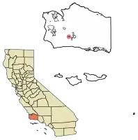 Location of Buellton in Santa Barbara County, California. | |
 Buellton Location in the United States | |
| Coordinates: 34°36′51″N 120°11′38″W | |
| Country | United States |
| State | California |
| County | Santa Barbara |
| Incorporated | February 1, 1992[1] |
| Government | |
| • Mayor | Holly Sierra |
| • State senator | Monique Limón (D)[2] |
| • Assemblymember | Steve Bennett (D)[2] |
| • U. S. rep. | Salud Carbajal (D)[3] |
| Area | |
| • Total | 1.58 sq mi (4.10 km2) |
| • Land | 1.58 sq mi (4.10 km2) |
| • Water | 0.00 sq mi (0.00 km2) 0.04% |
| Elevation | 358 ft (109 m) |
| Population (2010) | |
| • Total | 4,828 |
| • Estimate (2019)[6] | 5,102 |
| • Density | 3,225.03/sq mi (1,245.07/km2) |
| Time zone | UTC-8 (PST) |
| • Summer (DST) | UTC-7 (PDT) |
| ZIP code | 93427 |
| Area code(s) | 805 |
| FIPS code | 06-08758 |
| GNIS feature ID | 1667902 |
| Website | www |
With its convenient location at the junction of U.S. Route 101 and State Route 246, Buellton attracts many travelers. It is a town which is home to various hotels, restaurants, parks and shops. It may be most famous for its nickname “Home of Split Pea Soup,” which is a reference to Pea Soup Andersen's Restaurant. Buellton traces its beginnings to 1867 when a portion of a Mexican land grant was deeded Rufus T. Buell and his brother. They developed a successful cattle ranch in the 19th century.[7]
Geography
The town is surrounded by miles of open-space land in the Santa Ynez Valley, and borders the Santa Ynez River to the south. It is home to a library, one park, a golf course, fire station, Highway Patrol Office, a shopping plaza, 10 hotels and 18 restaurants.[8]
According to the United States Census Bureau, the city has a total area of 1.6 square miles (4.1 km2), 99.96% of it land and 0.04% of it water.
It is a common stop for travelers on U.S. Highway 101, being the first town north of Santa Barbara after the scenic and undeveloped stretch of about 25 miles (40 km) through the Gaviota Coast.
Demographics
| Historical population | |||
|---|---|---|---|
| Census | Pop. | %± | |
| 1970 | 1,402 | — | |
| 1980 | 2,364 | 68.6% | |
| 1990 | 3,506 | 48.3% | |
| 2000 | 3,828 | 9.2% | |
| 2010 | 4,828 | 26.1% | |
| 2019 (est.) | 5,102 | [6] | 5.7% |
| U.S. Decennial Census[9] | |||
2010
At the 2010 census Buellton had a population of 4,828. The population density was 3,050.3 people per square mile (1,177.7/km2). The racial makeup of Buellton was 3,912 (81.0%) White, 37 (0.8%) African American, 76 (1.6%) Native American, 137 (2.8%) Asian, 5 (0.1%) Pacific Islander, 424 (8.8%) from other races, and 237 (4.9%) from two or more races. Hispanic or Latino of any race were 1,451 persons (30.1%).[10]
The whole population lived in households, no one lived in non-institutionalized group quarters and no one was institutionalized.
There were 1,761 households, 667 (37.9%) had children under the age of 18 living in them, 1,008 (57.2%) were opposite-sex married couples living together, 168 (9.5%) had a female householder with no husband present, 81 (4.6%) had a male householder with no wife present. There were 93 (5.3%) unmarried opposite-sex partnerships, and 10 (0.6%) same-sex married couples or partnerships. 385 households (21.9%) were one person and 189 (10.7%) had someone living alone who was 65 or older. The average household size was 2.74. There were 1,257 families (71.4% of households); the average family size was 3.23.
The population was spread out, with 1,228 people (25.4%) under the age of 18, 391 people (8.1%) aged 18 to 24, 1,229 people (25.5%) aged 25 to 44, 1,343 people (27.8%) aged 45 to 64, and 637 people (13.2%) who were 65 or older. The median age was 39.1 years. For every 100 females, there were 95.5 males. For every 100 females age 18 and over, there were 94.2 males.
There were 1,845 housing units at an average density of 1,165.7 per square mile, of the occupied units 1,226 (69.6%) were owner-occupied and 535 (30.4%) were rented. The homeowner vacancy rate was 2.5%; the rental vacancy rate was 4.4%. 3,262 people (67.6% of the population) lived in owner-occupied housing units and 1,566 people (32.4%) lived in rental housing units.
2000
At the 2000 census there were 3,828 people in 1,433 households, including 1,000 families, in the city. The population density was 2,450.4 people per square mile (947.4/km2). There were 1,483 housing units at an average density of 949.3 per square mile (367.0/km2). The racial makeup of the city was 81.50% White, 0.55% African American, 1.15% Native American, 1.10% Asian, 0.21% Pacific Islander, 12.23% from other races, and 3.27% from two or more races. Hispanic or Latino of any race were 25.73%.[11]
Of the 1,433 households, 34.7% had children under the age of 18 living with them, 58.2% were married couples living together, 8.0% had a female householder with no husband present, and 30.2% were non-families. 23.9% of households were one person, and 10.7% were one person aged 65 or older. The average household size was 2.67 and the average family size was 3.17.
The age distribution was 27.1% under the age of 18, 6.7% from 18 to 24, 29.6% from 25 to 44, 23.0% from 45 to 64, and 13.6% 65 or older. The median age was 38 years. For every 100 females, there were 98.5 males. For every 100 females age 18 and over, there were 94.7 males.
The median income for a household in the city was $48,490, and the median family income was $54,839. Males had a median income of $46,379 versus $28,542 for females. The per capita income for the city was $20,907. About 6.6% of families and 8.8% of the population were below the poverty line, including 10.2% of those under age 18 and 7.3% of those age 65 or over.
History
Buellton is named for R.T. Buell who owned the Rancho San Carlos de Jonata Mexican land grant. It is the home of Pea Soup Andersen's, a major roadside stop and landmark on Route 101 since 1924. It has been a minor tourist destination since the 1920s, and became increasingly popular after the opening of Pea Soup Andersen's.[8] Buellton has also experienced increased notoriety due to the film Sideways (2004), which was filmed in Buellton and nearby Solvang.
Education
Buellton has two schools which form the Buellton Union Elementary School District. Oak Valley Elementary School serves those students in kindergarten through 5th grade while Jonata Middle School serves grades 6 through 8.[12] The district serves approximately 600 students. In 2019, Jonata Middle School was named a California Distinguished School while the Buellton Union Elementary School District was named a California Exemplary District.[13]
Public safety
The Santa Barbara County Sheriff's Office provides police services for Buellton, while the Santa Barbara County Fire Department acts as the local fire service. California Highway Patrol operates an office in town. The crime rate is low.[8]
Politics and government
As of February 2020, the current of mayor of Buellton is Holly Sierra, who was elected in November 2018.[14]
Activities
References
- "California Cities by Incorporation Date". California Association of Local Agency Formation Commissions. Archived from the original (Word) on November 3, 2014. Retrieved August 25, 2014.
- "Statewide Database". UC Regents. Archived from the original on February 1, 2015. Retrieved November 5, 2014.
- "California's 24th Congressional District - Representatives & District Map". Civic Impulse, LLC. Retrieved September 29, 2014.
- "2019 U.S. Gazetteer Files". United States Census Bureau. Retrieved July 1, 2020.
- "Buellton". Geographic Names Information System. United States Geological Survey. Retrieved November 5, 2014.
- "Population and Housing Unit Estimates". United States Census Bureau. May 24, 2020. Retrieved May 27, 2020.
- Palmer, Norma E. (1994). Santa Barbara & Ventura Counties. Automobile Club of Southern California. Pages 67-68. ISBN 9781564131867.
- McCormack, Don (1999). McCormack's Guides Santa Barbara and Ventura 2000. Mccormacks Guides. Page 48. ISBN 9781929365098.
- "Census of Population and Housing". Census.gov. Retrieved June 4, 2015.
- "2010 Census Interactive Population Search: CA - Buellton city". U.S. Census Bureau. Archived from the original on December 25, 2016. Retrieved July 12, 2014.
- "U.S. Census website". United States Census Bureau. Retrieved 2008-01-31.
- "Home". buelltonusd.org. Retrieved 2020-12-31.
- Hodgson, Mike. "Jonata Middle School, Buellton Union School District earn state honors". Santa Ynez Valley News. Retrieved 2020-12-31.
- "City Council - City of Buellton". City of Buellton. Retrieved February 17, 2020.
- Thornton, Stuart (2014). Moon Santa Barbara & the Central Coast. Avalon Publishing. Page 119. ISBN 9781612386997.
External links
| Wikimedia Commons has media related to Buellton, California. |
| Wikivoyage has a travel guide for Buellton. |
Municipalities and communities of Santa Barbara County, California, United States | ||
|---|---|---|
| Cities |  Santa Barbara County map | |
| CDPs | ||
| Unincorporated communities | ||
| Indian reservation | ||
| Ghost towns | ||
| ||
| Authority control |
|---|