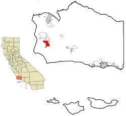
Lompoc, California
Lompoc (/ˈlɒmpoʊk/, LOM-poke) (Purisimeño: Lompo', "Stagnant Water")[10] is a city in Santa Barbara County, California. The city was incorporated on August 13, 1888. The population was 42,434 at the 2010 census, up from 41,103 at the 2000 census.
Lompoc | |
|---|---|
City | |
| City of Lompoc | |
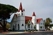
 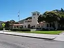  _(cropped).jpg.webp) 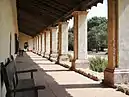 Clockwise from top: Downtown, Veterans Memorial Building, La Purísima Concepción Church, La Purisima Mission | |
| Nickname(s): Flower Seed Capital of the World, The City of Arts and Flowers | |
 Location in Santa Barbara County and the state of California | |
 Lompoc Location in the United States | |
| Coordinates: 34°38′46″N 120°27′37″W | |
| Country | United States |
| State | California |
| County | Santa Barbara |
| Incorporated | August 13, 1888[1] |
| Named for | Purisimeño: Lompoʔ: "Stagnant Water /Lagoon"[2] |
| Government | |
| • City council[3] | Mayor Jenelle Osborne, Gilda Cordova, Dirk Starbuck, Victor Vega, and James Mosby |
| • State senator | Monique Limón (D)[4] |
| • Assemblymember | Jordan Cunningham (R)[4] |
| • U.S. Rep. | Salud Carbajal (D)[5] |
| Area | |
| • Total | 11.70 sq mi (30.31 km2) |
| • Land | 11.62 sq mi (30.10 km2) |
| • Water | 0.08 sq mi (0.20 km2) 0.66% |
| Elevation | 105 ft (32 m) |
| Population | |
| • Total | 42,434 |
| • Estimate (2019)[9] | 42,853 |
| • Density | 3,686.91/sq mi (1,423.51/km2) |
| Demonym(s) | Lompocan |
| Time zone | UTC-8 (PST) |
| • Summer (DST) | UTC-7 (PDT) |
| ZIP codes | 93436–93438 |
| Area code | 805 |
| FIPS code | 06-42524 |
| GNIS feature ID | 1652745 |
| Website | www |
Before European settlers arrived, the area around Lompoc was inhabited by the Chumash people. The name of the city is derived from a Purisimeño term, "Lum Poc", which means "stagnant waters" or "lagoon". In 1837, the Mexican government sold the area as the Rancho Lompoc land grant. After the United States gained control of California in the Mexican–American War (1846–48), the valley was acquired by Thomas Dibblee, Albert Dibblee and William Welles Hollister. Hollister sold his share to the Lompoc Valley Land Company, and it was on that portion of the land that the present-day Lompoc was established as a temperance colony. [11]
Lompoc was intended to be named New Vineland, after the temperance colony in New Jersey. It then became a military town with the completion of nearby Camp Cooke (now Vandenberg Air Force Base). The city is known as the flower seed capital of the world.
History
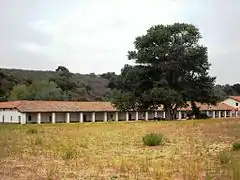
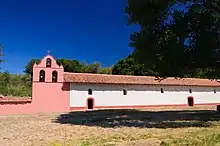
Prior to the Spanish conquest, the area around Lompoc was inhabited by the Chumash people. Original La Purisima Mission was established in 1787 near what is now the southern edge of the city. Purisimeño, a Chumashan language, was spoken in the region during the mission period.[12] After an earthquake destroyed the mission in 1812, it was relocated to its present location 1 mile (1.6 km) northeast of the present city. After independence from the Spanish Empire, the First Mexican Empire was established in 1821. The Mexicans secularized the Spanish missions in 1833, and La Purisima Mission fell into ruins.
In 1893, a diatomaceous earth mine, formerly Johns Manville, World Mineral, Celite corporation, now Imerys Inc., opened in the southern hills in Miguelito Canyon. It became (and still is) the largest marine diatomite mine in the world, and at one time was the largest employer in the valley. While owned by Johns Manville, the mine employed upwards of 900 people at its peak, and built housing for its employees onsite and in town, the houses in town are adjacent to JM park, which was donated to the city by the mine. Another diatomaceous earth company, Grefco, operated here from the 1940s till 1998.[13] The remnants of its mine at the northeast end of town were torn down in 2001.[14]
In 1909, the Sibyl Marston—at the time, the largest steam schooner built on the West Coast—sank nearby while carrying 1,100,000 board feet (2,600 m3) of lumber. Many of the older Lompoc homes were built with lumber from the shipwreck. The wreckage can still be seen south of Surf Beach.[15]
The coastal branch of the Southern Pacific Railroad opened around 1900 and eventually replaced ship transportation. A paved road linked Lompoc to Buellton and the rest of California around 1920. In 1923, the Honda Point disaster, the U.S.'s largest peacetime naval accident, occurred just off the coast; nine U.S. destroyers ran aground, killing 23 people. During the Great Depression, La Purisima Mission was restored by the Civilian Conservation Corps (CCC). During World War II, the coast west of Lompoc was the site of Camp Cooke, a United States Army training camp where large units could practice maneuvers.
Lompoc grew slowly until 1958, when the United States Air Force announced that the former Camp Cooke would be a test site for the Thor family of intermediate-range ballistic missiles and the first operational base for the SM-65 Atlas, an intercontinental ballistic missile. The city then began to grow rapidly to provide housing for thousands of civilians and contractors employed at what was soon renamed Vandenberg Air Force Base. It was the first missile base of the United States Air Force.
The Space Shuttle program was slated to begin launches in the late 1980s, and the city experienced a boom in restaurant and hotel construction in anticipation of tourists coming to see shuttle launches. However, when the Challenger exploded during take-off from Cape Canaveral in 1986, the West Coast shuttle program was terminated, sending Lompoc into a severe recession.
Lompoc is called "The City of Arts and Flowers" and is also becoming known for its wines. In 2010, Playboy named Jasper's, a local bar, one of the top 10 dive bars in the country.[16]
Geography
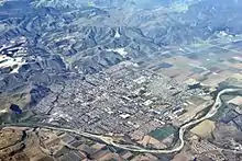
Lompoc is located at 34°38′46″N 120°27′37″W (34.646182, -120.460316).[17] According to the United States Census Bureau, the city has a total area of 11.7 square miles (30 km2), 99.34% of it land and 0.66% of it water.
Most of the city is in the valley of the Santa Ynez River, at an elevation of about 80–100 feet (25–30 meters); recent expansion has been to the north, on higher ground known as Vandenberg Village, with elevations of 150–300 feet (50–100 meters). Like most rivers in Southern California, the Santa Ynez River does not have a surface flow for most of the year. Underground flow in the sandy river bed recharges the aquifer beneath the city, from which nine wells (with a tenth one planned) supply the city with water. Unlike many other cities in Southern California, Lompoc is not connected to the State Water Project.
Climate
Lompoc has a cool Mediterranean climate (Köppen climate classification Csb), typical of coastal California. The city is mostly sunny, with an ocean breeze. Fog is common. Snow is virtually unknown. The highest recorded temperature was 110 °F or 43.3 °C in 1987, and the lowest recorded temperature was 15 °F or −9.4 °C in 2013.
| Climate data for Lompoc, California | |||||||||||||
|---|---|---|---|---|---|---|---|---|---|---|---|---|---|
| Month | Jan | Feb | Mar | Apr | May | Jun | Jul | Aug | Sep | Oct | Nov | Dec | Year |
| Average high °F (°C) | 64 (18) |
64 (18) |
66 (19) |
67 (19) |
68 (20) |
70 (21) |
72 (22) |
73 (23) |
74 (23) |
73 (23) |
68 (20) |
63 (17) |
68.5 (20.3) |
| Average low °F (°C) | 42 (6) |
44 (7) |
46 (8) |
47 (8) |
50 (10) |
53 (12) |
56 (13) |
56 (13) |
55 (13) |
51 (11) |
46 (8) |
42 (6) |
49 (9) |
| Average rainfall inches (mm) | 3.33 (85) |
3.71 (94) |
2.88 (73) |
1.01 (26) |
0.29 (7.4) |
0.04 (1.0) |
0.01 (0.25) |
0.03 (0.76) |
0.1 (2.5) |
0.74 (19) |
1.41 (36) |
2.56 (65) |
16.11 (409.91) |
| Source: Weather Channel[18] | |||||||||||||
Demographics
| Historical population | |||
|---|---|---|---|
| Census | Pop. | %± | |
| 1880 | 226 | — | |
| 1890 | 1,015 | 349.1% | |
| 1900 | 972 | −4.2% | |
| 1910 | 1,482 | 52.5% | |
| 1920 | 1,876 | 26.6% | |
| 1930 | 2,845 | 51.7% | |
| 1940 | 3,379 | 18.8% | |
| 1950 | 5,520 | 63.4% | |
| 1960 | 14,415 | 161.1% | |
| 1970 | 25,284 | 75.4% | |
| 1980 | 26,267 | 3.9% | |
| 1990 | 37,649 | 43.3% | |
| 2000 | 41,103 | 9.2% | |
| 2010 | 42,434 | 3.2% | |
| 2019 (est.) | 42,853 | [9] | 1.0% |
| U.S. Decennial Census[19] | |||
2010
In the 2010 United States Census,[20] Lompoc had a population of 42,434. The population density was 3,634.7 people per square mile (1,403.4/km2). The racial makeup was 25,950 (61.2%) White; 2,432 (5.7%) African American; 750 (1.8%) Native American; 1,615 (3.8%) Asian; 186 (0.4%) Pacific Islander; 9,020 (21.3%) from other races; and 2,481 (5.8%) from two or more races. There were 21,557 Hispanics or Latinos of any race (50.8%).
The Census reported that 38,778 people (91.4% of the population) lived in households, 99 (0.2%) lived in non-institutionalized group quarters, and 3,557 (8.4%) were institutionalized.
There were 13,355 households, of which 5,481 (41.0%) had children under the age of 18 living in them; 6,323 (47.3%) were opposite-sex married couples living together; 2,061 (15.4%) had a female householder with no husband present; and 913 (6.8%) had a male householder with no wife present. There were 949 (7.1%) unmarried opposite-sex partnerships and 75 (0.6%) same-sex married couples or partnerships. 3,304 households (24.7%) were made up of individuals, and 1,187 (8.9%) had someone living alone who was 65 years of age or older. The average household size was 2.9. There were 9,297 families (69.6% of all households); the average family size was 3.48.
The population included 11,188 people (26.4%) under the age of 18, 4,452 people (10.5%) aged 18 to 24, 12,233 people (28.8%) aged 25 to 44, 10,338 people (24.4%) aged 45 to 64, and 4,223 people (10.0%) who were 65 or older. The median age was 33.9 years. For every 100 females, there were 114.9 males. For every 100 females age 18 and over, there were 118.7 males.
There were 14,416 housing units at an average density of 1,234.8 per square mile (476.8/km2), of which 6,493 (48.6%) were owner-occupied and 6,862 (51.4%) were occupied by renters. The homeowner vacancy rate was 2.2%; the rental vacancy rate was 7.1%. 18,534 people (43.7% of the population) lived in owner-occupied housing units, and 20,244 people (47.7%) lived in rental housing units.
2000
As of the 2000 Census,[21] there were 43,284 people, 13,059 households and 9,311 families residing in Lompoc. The population density was 3,532.2 people per square mile (1,363.4/km2). There were 13,621 housing units at an average density of 1,170.5 per square mile (451.8/km2). The racial makeup of the city was 65.81% White, 7.34% African American, 1.58% Native American, 3.90% Asian, 0.32% Pacific Islander, 15.68% from other races, and 5.35% from two or more races. Hispanics or Latinos of any race were 37.31% of the population.
There were 13,059 households, of which 41.1% had children under the age of 18 living with them, 51.0% were married couples living together, 14.8% had a female householder with no husband present, and 28.7% were non-families. 23.5% of all households were made up of individuals, and 8.3% had someone living alone who was 65 or older. The average household size was 2.88, and the average family size was 3.42.
The population included 29.9% under the age of 18, 8.9% from 18 to 24, 33.3% from 25 to 44, 18.5% from 45 to 64, and 9.4% who were 65 or older. The median age was 32. For every 100 females, there were 113.0 males. For every 100 females age 18 and over, there were 116.4 males.
The median income for a household in the city was $47,587, and the median income for a family was $62,199. Males had a median income of $35,074, versus $26,824 for females. The per capita income was $15,509. About 12.6% of families and 15.4% of the population were below the poverty line, including 20.8% of those under 18 and 6.7% of those 65 or older.
Public safety
The Lompoc Police Department is the primary law enforcement agency for the city. The city is also served by the Lompoc Fire Department (LFD), which responds to more than 3,800 emergency and non-emergency calls per year.[22] American Medical Response Santa Barbara County (AMR SBC) provides the primary emergency medical response and ambulance services. The LFD provides mutual aid to the Santa Barbara County Fire Department as well as providing primary fire protection and emergency medical response to the United States Penitentiary, Lompoc.
The Federal Correctional Complex located between Lompoc and Vandenberg AFB includes the medium- and low-security Federal Correctional Institution, Lompoc, two minimum-security camps.[23]
Transportation
State Route 1 is the major north-south artery through Lompoc. State Route 246 heads east to Buellton and the Santa Ynez Valley.
The Surf train station is located to the west at Surf Beach and is served by Amtrak's Pacific Surfliner line. Thruway Motorcoach buses stop in town. Lompoc is also served by City of Lompoc Transit, the Clean Air Express to Santa Barbara/Goleta, and the Breeze Bus to Buellton/Solvang and Santa Maria.
Education
High schools
Economy
Vandenberg Air Force Base dominates the economy, directly employing a large percentage of Lompoc's residents and contributing $1.7 billion to the regional economy.[24] Vandenberg Air Force Base employs the most residents of Lompoc. They employ 6,889 residents.[25] Other mainstays of the economy include the Federal Correctional Institution, the diatomaceous earth mine (today owned by Imerys), the Lompoc Oil Field and associated oil processing facilities north of town, and agriculture (especially seed flowers and vegetables).
Wine production and wine tourism make up an expanding agricultural sector.[26] Lompoc Valley is the gateway to the Sta. Rita Hills AVA wine appellation, internationally recognized for premium pinot noir and chardonnay. Thirty premium boutique wine labels are produced in Lompoc. Numerous other wineries are located along State Route 246 and on Santa Rosa Road. Tasting rooms are located in various parts of Lompoc.[24]
Since the end of the Cold War, many workers employed in Santa Barbara and Goleta have moved to Lompoc to take advantage of lower housing costs, effectively making Lompoc a bedroom community of Santa Barbara.[27] The character of the town has changed considerably with the growth associated with this demographic shift. In addition, new housing developments are spreading into the adjacent hills on the north side of town.
Cannabis
Upon the legalization of the sale and distribution of cannabis in California, the city had seven recreational marijuana storefronts by February 2020 with nineteen cannabis business licenses having been issued by the city.[28][29] One of the retail establishment is being licensed for on site consumption claiming to be the first between Los Angeles and San Francisco.[30] A manufacturing facility has been established and a testing lab provides the required analysis for growers.[31][32] Companies must be licensed by the local agency and the state to grow, test, or sell cannabis and the city may authorize none or only some of these activities. Cannabis dispensaries pay a 6% gross sales tax to the city.[33] Local governments may not prohibit adults, who are in compliance with state laws, from growing, using, or transporting marijuana for personal use.
Arts and culture
The Lompoc Valley Flower Festival, held the last week of June, features a parade, carnival and craft show.[34] In 2002, the Bodger Seed Company planted a "floral flag" as a tribute after the September 11 attacks. The "flag" was 740 feet by 390 feet, covered 6.65 acres (2.69 ha), and was estimated to contain more than 400,000 larkspur plants.[35][36]
The Lompoc arts scene features a number of musicians and bands, ranging from singer-songwriters to psychedelic blues-rock bands. At the center of this scene is Howlin’ Byroon's Music Exchange, a music store and frequent venue for Lompoc's musicians. The shop opened in May 2009 and offers guitar lessons, consigned musical instruments and live performances.[37]
Local artists
One of Lompoc's most successful musical artists is the rock band Saint Anne's Place, which was formed in 2008 and originally featured Jacob Cole, Samuel Cole, JT Wild and Clive Hacker. Today, its members are the Coles and their cousin, Joel, a bassist.[38] They grew up playing in their families' blues bands[39] and released their first EP, Speak Easy, in 2011. The band's music has been described as a "blistering yet rustic mix of blues, psychedelia, and folk rock with the chops of players twice their senior".[40] In 2011, they won the Santa Barbara Independent battle of the bands.[41] They released their second EP, The Earth Shaker, in December 2012 to positive reviews by the local media.[42]
Emily Wryn is a Lompoc songwriter whose music has been featured on NPR’s Morning Becomes Eclectic.[43] Her first EP, Head on Straight, was released in February 2012,[44] and she played at the Indie Week festival in Ireland in April 2014.[45] Wryn also collaborates with a local band, Saint Anne's Place, in a group called The Lights Electric.
Another band, Millions, led by Randall Sena, plays along the Central Coast.[46] Sena recorded and produced Wryn's Head on Straight and Saint Anne's Place's Speak Easy in his recording studio, Certain Sparks.[44]
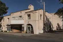
Lompoc Theatre
The Lompoc Theatre, which opened in 1927, was owned and operated by the Calvert family for many years.[47] It encountered financial trouble in the 1970s because of competition from multiplexes and television. The last time a movie was shown on its screen was in 1987.[48]
In July 2003, a non-profit group, the Lompoc Housing and Community Development Corporation, announced plans to restore the theater. With the assistance of the city, the LHCDC was able to raise funds to buy the theater. By March 2008, the cost of renovating the building was estimated at just under $10 million. The LHCDC was unable to raise the money needed for renovations, and the building accumulated three liens.[49] It was sold to a grassroots group called the Lompoc Theatre Project in 2016. As of January 2020, restoration and fund-raising is still ongoing.[50][51][52][53]
Lompoc Pops Orchestra
The Lompoc Pops Orchestra has been performing for 20 years. Composed of approximately 45 semi-professional musicians, under the direction of Dr. Brian Asher Alhadeff, its four annual performances include musicals, Broadway hits, jazz pieces, big band, gospel and patriotic music.
Notable people
- Julian Araujo, professional soccer player (LA Galaxy)[54]
- Jeff Bettendorf, professional baseball player (Oakland Athletics)[55]
- Mike Bratz, former professional basketball player (San Antonio Spurs, Cleveland Cavaliers, Chicago Bulls, Golden State Warriors, Sacramento Kings, Phoenix Suns)[56]
- Casey Candaele, former professional baseball player (Montreal Expos, Houston Astros, and Cleveland Indians)[57]
- Ryan Church, former professional baseball player (Washington Nationals, New York Mets, Atlanta Braves, Pittsburgh Pirates, and Arizona Diamondbacks)[58]
- Jeffrey Combs, actor, raised in Lompoc[59]
- Danny Duffy, professional baseball player (Kansas City Royals)[60]
- Jacqueline Gadsden, 1920s film actress, born in Lompoc[61]
- Brian Givens, former professional baseball player (Milwaukee Brewers)[62]
- Johnnie Gray, former professional football player (Green Bay Packers)[63]
- Mark Herrier, actor, graduated from Lompoc High School[64]
- Winifred Hervey, executive producer and writer, The Fresh Prince of Bel-Air and The Steve Harvey Show
- Roy Howell, former professional baseball player (Texas Rangers, Toronto Blue Jays, and Milwaukee Brewers)[65]
- Bill Howerton, former professional baseball player (St. Louis Cardinals, Pittsburgh Pirates, and New York Giants)[66]
- Napoleon Kaufman, former professional football player (Oakland Raiders)[67]
- Gabe Lopez, singer/songwriter
- John D. Nesbitt, western writer and American literature and language educator living in Wyoming.
- George Perry, Alzheimer's disease researcher and dean and professor of biology at the University of Texas at San Antonio
- Duane Solomon, 800m Olympian[68]
- Roy Thomas, former professional baseball player (Seattle Mariners)
- Tommy Thompson, former professional football player (San Francisco 49ers)[69]
- Dorien Wilson, actor, The Parkers and Dream On[70]
Sister cities
Lompoc has five sister cities:[71]
Tourist attractions
References
- "California Cities by Incorporation Date". California Association of Local Agency Formation Commissions. Archived from the original (Word) on November 3, 2014. Retrieved August 25, 2014.
- McCall, Lynne; Perry, Rosalind (2002). California's Chumash Indians : a project of the Santa Barbara Museum of Natural History Education Center (Revised ed.). San Luis Obispo, Calif: EZ Nature Books. ISBN 978-0936784151.
- "Welcome to the City of Lompoc!". City of Lompoc. Retrieved January 4, 2015.
- "Statewide Database". UC Regents. Archived from the original on February 1, 2015. Retrieved January 4, 2015.
- "California's 24th Congressional District - Representatives & District Map". Civic Impulse, LLC. Retrieved September 29, 2014.
- "2019 U.S. Gazetteer Files". United States Census Bureau. Retrieved July 1, 2020.
- "Lompoc". Geographic Names Information System. United States Geological Survey. Retrieved November 17, 2014.
- "Lompoc (city) QuickFacts". United States Census Bureau. Archived from the original on March 23, 2015. Retrieved March 16, 2015.
- "Population and Housing Unit Estimates". United States Census Bureau. May 24, 2020. Retrieved May 27, 2020.
- McCall, Lynne & Rosalind, Perry, red. (1991): The Chumash People: Materials for Teachers and Students. Santa Barbara Museum of Natural History. San Luis Obispo, CA: EZ Nature Books. ISBN 0-945092-23-7. Page 29.
- Aug 03, Michael Redmon Wed; 2016 | 12:00am (August 3, 2016). "The Founding of Lompoc". The Santa Barbara Independent. Retrieved May 10, 2020.
- "Purisimeño". Survey of California and Other Indian Languages. Retrieved July 22, 2012.
- Sakata, John (September 23, 2011). "Owner has plans for Grefco site". Lompoc Record. Retrieved February 9, 2020.
- Zimmer, Shane (June 4, 2001). "Lompoc landmark falls". Santa Maria Times. Retrieved February 9, 2020.
- Nisperos, Neil (January 29, 2006), "Merchant steamer ship visible at Surf Beach", Lompoc Record, retrieved June 9, 2013
- Glenn Wallace (July 24, 2010). "Jasper's makes list of top 'dive bars'". The Lompoc Record. Retrieved July 25, 2010.
- "US Gazetteer files: 2010, 2000, and 1990". United States Census Bureau. February 12, 2011. Retrieved April 23, 2011.
- "Average Weather for Lompoc/Vandenberg AFB, CA - Temperature and Precipitation". The Weather Channel. February 2012. Retrieved February 23, 2012.
- "Census of Population and Housing". Census.gov. Retrieved June 4, 2015.
- "2010 Census Interactive Population Search: CA - Lompoc city". U.S. Census Bureau. Archived from the original on July 15, 2014. Retrieved July 12, 2014.
- "U.S. Census website". United States Census Bureau. Retrieved January 31, 2008.
- "Welcome to the City of Lompoc!". cityoflompoc.com.
- Archived November 26, 2013, at the Wayback Machine
- "Editorial: Lompoc gets its groove back amid tourism boom". Pacific Coast Business Times. February 6, 2015. Retrieved July 2, 2015.
- http://www.cityoflompoc.com/EconDev/majorindustries.htm
- "'Sip Lompoc' campaign brings local wine industry under spotlight". Lompoc Record. December 1, 2019. Retrieved December 2, 2019.
- Magnoli, Giana (May 18, 2019). "Board of Supervisors Considers Expanding Commuter Benefits for Santa Barbara County Employees". Noozhawk. Retrieved September 5, 2019.
- Jacobson, Willis (February 8, 2020). "Coastal Dispensary opens in downtown Lompoc, becomes city's 7th cannabis storefront". Lompoc Record. Retrieved February 8, 2020.
- "New cannabis retail shop opens in Lompoc". KSBY. September 30, 2019. Retrieved October 1, 2019.
- "New cannabis shop opening in Lompoc to allow on-site consumption". KSBY. December 12, 2019. Retrieved December 13, 2019.
- Abbott, Anikka (September 1, 2020). "Lompoc cannabis testing lab pivots to COVID-19 testing". KEYT. Retrieved September 2, 2020.
- Hill, Naja (December 17, 2019). "The only cannabis testing lab on the Central Coast to open in Lompoc". KEYT | KCOY. Retrieved December 17, 2019.
- Hill, Naja (May 14, 2019). "Lompoc sees less cannabis revenue than expected but predicts future profits to come". KEYT. Retrieved May 14, 2019.
- Fodor's (December 21, 2010). Fodor's Northern California 2011: With Napa, Sonoma, Yosemite, San Francisco & Lake Tahoe. Random House Digital, Inc. p. 70. ISBN 978-1-4000-0503-1. Retrieved December 25, 2011.
- "The 2002 Floral Flag". City of Lompoc. Archived from the original on May 17, 2013. Retrieved June 17, 2014.
- "Floral Flag". snopes.com.
- Poertner, Bo (November 30, 2010). "Untapped talent". Lompocrecord.com. Retrieved July 2, 2015.
- "Saint Anne's Place The Santa Barbara Independent". independent.com.
- Aly Comingore (July 12, 2012). "Catching up with Saint Anne's Place". independent.com.
- Aly Comingore (November 3, 2011). "Heavy Hitters". independent.com.
- Aly Comingore (October 21, 2011). "Saint Anne's Takes First Place". independent.com.
- Aly Comingore (December 28, 2012). "Saint Anne's Place Release The Earth Shaker". independent.com.
- "Woman of Indie: Emily Wryn – Head on Straight". Indiemusicreviewer.com. March 11, 2012. Retrieved July 2, 2015.
- Aly Comingore (February 6, 2012). "Emily Wryn". independent.com.
- iwiAdmin99. "Categories Archives: 2013 Performers". Indie Week Ireland. Retrieved March 18, 2014.
- Levi Michaels (November 3, 2011). "The Songwriter-Producer: Millions". independent.com.
- McReynolds, John (May 27, 2007). "Grand Lompoc Theatre once a showcase". The Lompoc Record. Retrieved March 19, 2014.
- Benham, Carol (August 5, 2012). "Fate of Lompoc Theatre in hands of City Council". The Lompoc Record. Retrieved March 19, 2014.
- Benham, Carol (August 5, 2012). "Timeline of LHCDC's plans for the Lompoc Theatre". The Lompoc Record. Retrieved March 19, 2014.
- Cruet, Gianna (February 21, 2014). "Lompoc Theatre Project presents updated plans". The Lompoc Record. Retrieved March 19, 2014.
- Jacobson, Willis (January 29, 2016). "Lompoc Theatre Project takes ownership of historic building". The Lompoc Record. Retrieved February 9, 2016.
- "Lompoc Theatre Project: Restoring the Historic Lompoc Theatre". Lompoc Theatre Project. Retrieved February 10, 2016.
- Jacobson, Willis (April 27, 2017). "Lompoc's landmark 'Hi! Let's Eat' sign survives, gets new home". Lompoc Record. Retrieved May 8, 2017.
- "Julian Araujo". MLSsoccer.com. Retrieved October 16, 2019.
- "Jeff Bettendorf Stats". Baseball Almanac. Retrieved December 21, 2012.
- "Michael Louis Bratz (Mike)". databaseBasketball.com. Archived from the original on January 20, 2013. Retrieved December 27, 2012.
- "Casey Candaele Stats". Baseball Almanac. Retrieved December 21, 2012.
- "Ryan Church Stats". Baseball Almanac. Retrieved December 21, 2012.
- "Jeffrey Combs". New York Times. Retrieved April 6, 2015.
- "Danny Duffy Stats". Baseball Almanac. Retrieved December 27, 2012.
- "Jacqueline Gadsdon - Biography - IMDb". IMDb. Retrieved September 10, 2017.
- "Brian Givens Stats". Baseball Almanac. Retrieved December 21, 2012.
- "Johnnie Lee Gray". databaseFootball.com. Archived from the original on January 20, 2013. Retrieved December 27, 2012.
- "Mark Herrier - Biography - IMDb". IMDb. Retrieved September 10, 2017.
- "Roy Howell Stats". Baseball Almanac. Retrieved December 21, 2012.
- "Bill Howerton Stats". Baseball Almanac. Retrieved December 21, 2012.
- "Napoleon Kaufman". databaseFootball.com. Archived from the original on January 20, 2013. Retrieved December 27, 2012.
- "Duane Solomon". usatf.org.
- Archived October 20, 2012, at the Wayback Machine
- "Dorien Wilson". IMDb. Retrieved May 10, 2020.
- "Our Sister Cities". City of Lompoc. Retrieved February 25, 2015.
External links
| Wikimedia Commons has media related to Lompoc, California. |
| Wikivoyage has a travel guide for Lompoc. |
- Official website

- Lompoc Visitors Information Website
- Lompoc Valley Historical Society
- Lompoc Valley Chamber of Commerce & Visitors Bureau
- Lompoc Flower Festival Association
Municipalities and communities of Santa Barbara County, California, United States | ||
|---|---|---|
| Cities | 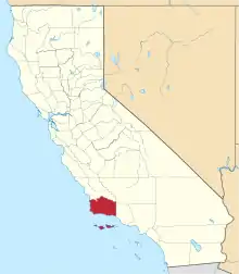 Santa Barbara County map | |
| CDPs | ||
| Unincorporated communities | ||
| Indian reservation | ||
| Ghost towns | ||
| ||
| Counties |  | |
|---|---|---|
| Cities and towns 100k-250k | ||
| Cities and towns 25k-100k | ||
| Cities and towns 10k-25k | ||
| Sub-regions | ||
Counties in italics sometimes included in the definition of the Central Coast | ||