Gaviota Coast
The Gaviota Coast in Santa Barbara County, California is a rural coastline along the Santa Barbara Channel roughly bounded by the city of Goleta and the north boundary of the county. This last undeveloped stretch of Southern California coastline consists of dramatic bluffs, isolated beaches and terraced grasslands.
| Gaviota Coast | |
|---|---|
 Location within California | |
| Location | Santa Barbara County, California |
| Coordinates | 34°28′15″N 120°13′29″W |
| Offshore water bodies | Pacific Ocean |
| Elevation | 23 feet (7 m)[1] |
| Length | 76 miles (122 km) |
| Area | 200,000 hectares (490,000 acres) |
| GNIS feature ID | 1702035[1] |
| ZIP codes | 93117, 93436 |
History
Sites inhabited in the Paleoindian Period (13,000–8,500 B.P.) have been found through archeological deposits at the mouths of rivers and along the seashore where there was an abundance of food. At least fourteen Chumash villages were located along the coastline including Qasil, Tajiguas, and Shishuchi'i'.[2]
The Spanish began colonizing Alta California with the Portolá expedition of 1769–1770. Much of the area is within the 1794 Spanish land grant, Rancho Nuestra Señora del Refugio.
Congress ordered a study in 1999 for a proposed 76-mile-long (122 km) National Seashore from Coal Oil Point at UC Santa Barbara to Point Sal at the northern boundary of Vandenberg Air Force Base.[3] Although the National Park Service found the area suitable with nationally significant natural and cultural resources,[2] the study found the establishment to not be feasible due to local opposition within the approximately 200,000 acres (81,000 ha) study area and the high cost of acquiring land and running a new park.[4][5]
Geography
Situated on a narrow coastal terrace between a rugged coastline and the Santa Ynez Mountains of the Los Padres National Forest,[6] the area has a Mediterranean climate. The coastal waters are considered unique for the biodiversity of ocean life.[7][8] The unusual species found here are the result of the cold water from the north meeting the warm water from the south.[9] The annual migration of about 19,000 Gray whales through the Santa Barbara Channel may come as close as 100 feet (30 m) from the shoreline.[9] The unusual abundance and diversity of wildlife includes an estimated 1,400 plant and animal species.[3] The Santa Ynez Mountains are a migration corridor for wildlife from the large interior region of California. Wildlife includes mountain lions, black bears, badgers, golden eagles, and the California condor.[10]
The Gaviota Creek watershed is the largest watershed along this coast and is the most important steelhead stream in Southern Santa Barbara County.[11] Refugio Creek is one of the larger coastal streams along the coast and descends through a mosaic of commercial orchards, ranches, and rural residential developments and crosses under Highway 101 before flowing into the Pacific Ocean.[12]
Land use
The narrow coastal terrace is primarily used for recreation and cattle grazing.[6] The county adopted a coastal land use plan in 1982 that was consistent with their policies and development standards to preserve the natural scenic beauty.[13] The lightly populated area has large ranches with much of the land held in agricultural preserves under the Williamson Act and used for avocado, lemon and other fruit orchards.[14] Some of the ranches are also luxury estates.[15] El Rancho Tajiguas is a 3,600 acres (1,500 ha) working ranch that was developed with two luxury homes over a period of 40 years under the ownership of Mansour Ojjeh.[16][17] The 1,800 acres (730 ha) Las Varas Ranch was purchased by Charlie Munger and donated to the University of California, Santa Barbara in 2018.[18]
The Hondo and Harmony oil rigs can be easily seen offshore in front of the Channel Islands in the Santa Barbara Channel from the highway or railroad.[19] Crude oil and natural gas are produced by these offshore platforms. Local land use agencies have kept oil processing facilities to a minimum while the oil and gas are processed at onshore receiving plants before being transported to distant refineries. The area was one of the earliest locations in California developed for offshore oil and gas production.
Protected areas along US 101 include three public beaches with campgrounds and hiking trails: Gaviota State Park, El Capitán State Beach, and Refugio State Beach.[20] There are also several marine protected area off the coast: Point Conception State Marine Reserve, Naples State Marine Conservation Area, and Kashtayit State Marine Conservation Area. There are also several private campgrounds.[21]
Transportation
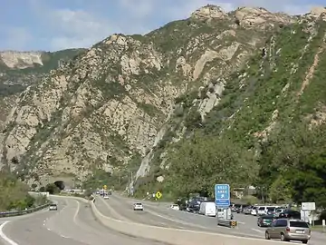
US 101 and the main coastal railroad line both parallel the coastline atop the coastal bluff. The 21-mile-long (34 km) section of US 101 from the north boundary of Goleta to State Route 1 at Las Cruces is designated by the state as a scenic highway.[22] The coastal bluff section of the rail line is longer at 30 miles (48 km).[23] An Interim California Coastal Trail alignment from Guadalupe to Gaviota State Park is under study.[24][25][26] These routes follow Chumash and Spanish Period trails.[2]
References
- U.S. Geological Survey Geographic Names Information System: Gaviota Beach
- Draft Gaviota Coast Feasibility Study & Environmental Assessment study of the National Park Service (PDF). Cultural Resources (Report). 2003. pp. 27–35. Archived from the original (PDF) on 2004-09-01.
 This article incorporates public domain material from websites or documents of the National Park Service.
 - Kenneth R., Weiss (2004-03-10). "Status as National Seashore Rejected for Gaviota Coast". Los Angeles Times. Retrieved 2020-09-16.
- Sherman, Mark (April 9, 2003). "Park Service says Gaviota Coast should not be national park". Napa Valley Register. Associated Press. Retrieved 2020-09-24.
- Assistant Secretary for Fish and Wildlife and Parks, United States Department of the Interior (March 5, 2004). "Gaviota Coast Feasibility Study" (PDF). Letter to Richard Pombo Chairman, Committee on Resources House of Representatives. Archived from the original (PDF) on 2004-07-03. Retrieved 2020-12-02.
- "Gaviota Coast Artichoke Thistle Project". Weed Management Area. County of Santa Barbara. Retrieved September 15, 2020.
- Burns, Melinda (May 20, 2015). "'Nightmare' California oil spill damages rare coastal ecosystem". The Guardian. Retrieved September 15, 2020.
- "Santa Barbara Oil Spill Reopens Fierce Environmental Debate". NPR News. May 23, 2015. Retrieved September 15, 2020.
- Patel, Neel V. (May 22, 2015). "What the Oil Spill Off Santa Barbara Is Going to Kill". WIRED. Retrieved September 17, 2020.
- "Coastal Clash: How Beaches Work: Recreation & Preservation: The Gaviota Coast". KQED. 2004. Retrieved 2021-01-31.
- Coastal Ranches Conservancy (February 2016). The Gaviota Creek Watershed: A Restoration Plan Update (Draft) (PDF) (Report). Retrieved December 26, 2020 – via County of Santa Barbara.
- "VENTURA FWO: Biologists Get Into the Dirt to Restore Native Plants at Coastal Riparian Site". www.fws.gov. March 28, 2008. Retrieved 2020-12-18.
- County of Santa Barbara (October 26, 2016). "RE: Letter of Intent for the State Scenic Highway Designation of Highway 101 along the Gaviota Coast" (PDF). Letter to California Department of Transportation. Retrieved 2020-12-29.
- Kester, Andria (April 27, 2017). "Saving The Gaviota Coast". Odyssey Online. Antioch University, Santa Barbara. Retrieved 2020-09-22.
- Yamamura, Jean (2020-12-09). "Two Pieces of Paradise Up for Auction". The Santa Barbara Independent. Retrieved 2021-01-18.
- Walker, Howard (2019-03-04). "Home of the Week: A 3,500-acre, $110 Million Slice of Santa Barbara Paradise". Robb Report. Retrieved 2020-12-30.
- Perino, Marissa (March 5, 2019). "A sprawling, 3500-acre cliffside ranch with 2 luxury villas and 120 cows could break the Santa Barbara real-estate record — here's a look inside". Business Insider. Retrieved 2021-01-30.
- Hamm, Keith (2018-12-12). "UCSB Gifted Las Varas Ranch". The Santa Barbara Independent. Retrieved 2020-12-31.
- Staff/Roadside Attractions (May 6, 2008). "Drivers can/t miss view of oil platforms". Lompoc Record. Retrieved September 17, 2020.
- "Gaviota Coast: SoCal's Celebrated Rural Shoreline". KCET. 2015-08-14. Retrieved 2020-12-18.
- Jaffe, Matthew (July 2007). "Gaviota's Endless beach". Sunset magazine. Archived from the original on 2007-10-16. Retrieved 2020-12-28.
- "Scenic Highways". Caltrans. Retrieved 2020-10-06.
- Slack, Gordy. "Saving the Seagull Coast". Land & People. The Trust for Public Land. Retrieved 2020-12-01.
- "New Interactive Story Map Illustrates Guadalupe-to-Gaviota Trail". Santa Barbara County Trails Council. 2020-11-01. Retrieved 2020-12-01 – via Edhat.
- "Exploring New Trail Routes from Gaviota to Guadalupe – The Northern Santa Barbara County Interim California Coastal Trail Study". Santa Barbara County Trails Council. Retrieved 2020-12-01.
- California Coastal Trail – Gaviota Segment: Draft Mitigated Negative Declaration (PDF) (Report). California Department of Parks and Recreation. July 2007. Retrieved December 26, 2020.
External links
- Gaviota Coast Plan, County of Santa Barbara, November 8, 2016
- Gaviota: The End of Southern California - 2017 documentary movie on the biodiversity of the Gaviota Coast with an emphasis on the marine and terrestrial wildlife at IMDb
| Counties |  | |
|---|---|---|
| Cities and towns 100k-250k | ||
| Cities and towns 25k-100k | ||
| Cities and towns 10k-25k | ||
| Sub-regions | ||
Counties in italics sometimes included in the definition of the Central Coast | ||