Bundaberg East
Bundaberg East is a suburb of Bundaberg in the Bundaberg Region, Queensland, Australia.[2] In the 2016 census Bundaberg East had a population of 2,784 people.[1]
| Bundaberg East Bundaberg, Queensland | |||||||||||||||
|---|---|---|---|---|---|---|---|---|---|---|---|---|---|---|---|
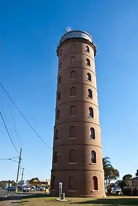 View looking West. The East Water Tower was erected in 1901-1902 to provide suitable water pressure as part of Bundaberg's new reticulated water system. | |||||||||||||||
 Bundaberg East | |||||||||||||||
| Coordinates | 24.8594°S 152.3747°E | ||||||||||||||
| Population | 2,784 (2016 census)[1] | ||||||||||||||
| • Density | 605/km2 (1,568/sq mi) | ||||||||||||||
| Postcode(s) | 4670 | ||||||||||||||
| Area | 4.6 km2 (1.8 sq mi) | ||||||||||||||
| Time zone | AEST (UTC+10:00) | ||||||||||||||
| Location | |||||||||||||||
| LGA(s) | Bundaberg Region | ||||||||||||||
| State electorate(s) | Bundaberg | ||||||||||||||
| Federal Division(s) | Hinkler | ||||||||||||||
| |||||||||||||||
History
A Government land sale of eighty allotments was advertised for auction by W.E.Curtis June 6, 1882.[3] The map advertising the auction stated the allotments were down river a mile from Bundaberg and fronted Scotland Street, Princes Street and George Street, located near Cran & Co's Refinery and Manchester & Scott's Saw Mills.[4]
St Matthew's Anglican Church Bundaberg East was opened in 1906 and closed in 1975. It was sold because of population drift.[5]
Bundaberg East State School opened on 1 July 1886.[6]
In the 2011 census, Bundaberg East had a population of 2,810 people.[7]
In the 2016 census Bundaberg East had a population of 2,784 people.[1]
Heritage listings
Bundaberg East has a number of heritage-listed sites, including:
- Bourbong Street: Kennedy Bridge[8]
- Quay Street: Saltwater Creek Railway Bridge[9]
- 17 Sussex Street: East Bundaberg Water Tower[10]
Education
Bundaberg East State School is a government primary (Prep-6) school for boys and girls at 33 Scotland Street (24.8622°S 152.3725°E).[11][12] In 2018, the school had an enrolment of 587 students with 41 teachers (36 full-time equivalent) and 36 non-teaching staff (22 full-time equivalent).[13] It includes a special education program.[11]
There is no secondary school in Bundaberg East. The nearest secondary schools are Kepnock State High School in neighbouring Kepnock to the south and Bundaberg State High School in neighbouring Bundaberg South to the south-west.[14]
References
- Australian Bureau of Statistics (27 June 2017). "Bundaberg East (SSC)". 2016 Census QuickStats. Retrieved 20 October 2018.

- "Bundaberg East – suburb in Bundaberg Region (entry 50194)". Queensland Place Names. Queensland Government. Retrieved 26 December 2020.
- "Advertising". Morning Bulletin. XXVIII (4425). Queensland, Australia. 27 May 1882. p. 3. Archived from the original on 1 February 2021. Retrieved 27 August 2019 – via National Library of Australia.
- "East Bundaberg". rosettadel.slq.qld.gov.au. Archived from the original on 1 February 2021. Retrieved 27 August 2019.
- "Closed Anglican Churches". Anglican Church South Queensland. Archived from the original on 3 April 2019. Retrieved 29 June 2020.
- Queensland Family History Society (2010), Queensland schools past and present (Version 1.01 ed.), Queensland Family History Society, ISBN 978-1-921171-26-0
- Australian Bureau of Statistics (31 October 2012). "Bundaberg East (SSC)". 2011 Census QuickStats. Retrieved 28 May 2016.
- "Kennedy Bridge (entry 600367)". Queensland Heritage Register. Queensland Heritage Council. Retrieved 7 July 2013.
- "Saltwater Creek Railway Bridge (entry 600370)". Queensland Heritage Register. Queensland Heritage Council. Retrieved 7 July 2013.
- "East Water Tower (entry 600369)". Queensland Heritage Register. Queensland Heritage Council. Retrieved 7 July 2013.
- "State and non-state school details". Queensland Government. 9 July 2018. Archived from the original on 21 November 2018. Retrieved 21 November 2018.
- "Bundaberg East State School". Archived from the original on 19 April 2012. Retrieved 21 November 2018.
- "ACARA School Profile 2018". Australian Curriculum, Assessment and Reporting Authority. Archived from the original on 27 August 2020. Retrieved 28 January 2020.
- "Queensland Globe". State of Queensland. Retrieved 1 February 2021.
External links
![]() Media related to Bundaberg East, Queensland at Wikimedia Commons
Media related to Bundaberg East, Queensland at Wikimedia Commons