Mon Repos, Queensland
Mon Repos is a coastal locality in the Bundaberg Region, Queensland, Australia.[2] In the 2016 census Mon Repos had a population of 30 people.[1]
| Mon Repos Queensland | |||||||||||||||
|---|---|---|---|---|---|---|---|---|---|---|---|---|---|---|---|
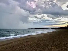 Mon Repos Beach, 2020 | |||||||||||||||
 Mon Repos | |||||||||||||||
| Coordinates | 24.8049°S 152.4405°E | ||||||||||||||
| Population | 30 (2016 census)[1] | ||||||||||||||
| • Density | 4.8/km2 (12.5/sq mi) | ||||||||||||||
| Postcode(s) | 4670 | ||||||||||||||
| Area | 6.2 km2 (2.4 sq mi) | ||||||||||||||
| Time zone | AEST (UTC+10:00) | ||||||||||||||
| Location | |||||||||||||||
| LGA(s) | Bundaberg Region | ||||||||||||||
| State electorate(s) | Burnett | ||||||||||||||
| Federal Division(s) | Hinkler | ||||||||||||||
| |||||||||||||||
Geography
Mon Repos Beach (24.7960°S 152.4416°E) is a long sandy beach along most of the coastline at Mon Repos.[3][4]
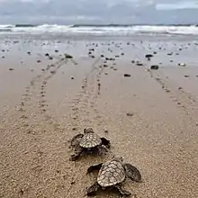
Most of the coastline is within the Mon Repos Conservation Park (24.7954°S 152.4400°E), established to protect the nesting areas of turtles. The north of the locality is still used fo agriculture, a mixture of grazing and crop growing. The south of the locality is reserved for environmental purposes. There are some small pockets of housing and a caravan park on the coast [4]
History
Mon Repos is French for "My Rest" and was the name of the homestead established by Augustus Purling Barton in the early 1880s.[5][6]
In the 1890s, the governments of France, Queensland and New South Wales decided to construct an undersea telegraph cable to link Australia to North America across the Pacific Ocean via New Caledonia, Fiji, Samoa, and Hawaii. The cable came ashore at Mon Repos, where a cable station was constructed. The cable was used until the 1920s when it was replaced by a radio service via Sydney and the cable station demolished. The cables remained in place under the sea where they were used during World War II by the Royal Australian Navy to train crews in midget submarines operating from HMS Bonaventure to cut cables in preparation to cut undersea telephone cables in Tokyo. Two lieutenants Bruce Enzer and Bruce Carey died during the training. Some remains of the cable station can be seen within the caravan park.[7]
Sandhills Provisional School opened on 20 March 1893. On 1 January 1909 it became Sandhills State School. In January 1921 it was renamed Bargara State School.[8]
In 1912 pioneer aviator Bert Hinkler launched one of his first home-made gliders on Mon Repos Beach and flew 10 metres (33 ft) above the sand dunes.[9][10]
In the 2016 census Mon Repos had a population of 30 people.[1]
Heritage listings
.jpg.webp)
Mon Repos has a number of heritage-listed sites, including:
- Grange Road: South Sea Islander Wall[11]
Education
Despite the name, Bargara State School is a government primary (Prep-6) school for boys and girls at 591 Bargara Road in Mon Repos (24.8221°S 152.4387°E).[12][13] In 2018, the school had an enrolment of 448 students with 31 teachers (26 full-time equivalent) and 22 non-teaching staff (13 full-time equivalent).[14]
There are no secondary schools in Mon Repos. The nearest secondary school is Kepnock State High School in Kepnock in Bundaberg to the south-west.[15]
Facilities
Despite the name, Bargara SES Facility is at 18 Potters Road in Mon Repos (24.8219°S 152.4390°E).[16]
References
- Australian Bureau of Statistics (27 June 2017). "Mon Repos (SSC)". 2016 Census QuickStats. Retrieved 20 October 2018.

- "Mon Repos – locality in Bundaberg Region (entry 44747)". Queensland Place Names. Queensland Government. Retrieved 26 December 2020.
- "Mountain ranges beaches and sea passages - Queensland". Queensland Open Data. Queensland Government. 12 November 2020. Archived from the original on 25 November 2020. Retrieved 25 November 2020.
- "Queensland Globe". State of Queensland. Retrieved 15 January 2021.
- "South Sea Islander Wall (entry 602230)". Queensland Heritage Register. Queensland Heritage Council. Retrieved 1 August 2014.
- "Family Notices". Maryborough Chronicle, Wide Bay and Burnett Advertiser (Qld. : 1860 – 1947). Qld.: National Library of Australia. 5 January 1885. p. 2. Archived from the original on 14 January 2021. Retrieved 11 November 2015.
- "Mon Repos Cable Station Remains" (PDF). Bundaberg Regional Council. Archived (PDF) from the original on 6 January 2016. Retrieved 11 November 2015.
- Queensland Family History Society (2010), Queensland schools past and present (Version 1.01 ed.), Queensland Family History Society, ISBN 978-1-921171-26-0
- "Up, up and away: Aussie aviator Bert Hinkler's start on Mon Repos Beach". Bundaberg Regional Council. Archived from the original on 1 November 2020. Retrieved 14 January 2021.
- "Hinkler Hall of Aviation - History". Discover Bundaberg. Archived from the original on 29 October 2020. Retrieved 14 January 2021.
- "South Sea Islander Wall (entry 602230)". Queensland Heritage Register. Queensland Heritage Council. Retrieved 7 July 2013.
- "State and non-state school details". Queensland Government. 9 July 2018. Archived from the original on 21 November 2018. Retrieved 21 November 2018.
- "Bargara State School". Archived from the original on 1 April 2020. Retrieved 21 November 2018.
- "ACARA School Profile 2018". Australian Curriculum, Assessment and Reporting Authority. Archived from the original on 27 August 2020. Retrieved 28 January 2020.
- "Queensland Globe". State of Queensland. Retrieved 14 January 2021.
- "Emergency services facilities - Queensland". Queensland Open Data. Queensland Government. 18 November 2020. Archived from the original on 24 November 2020. Retrieved 24 November 2020.
External links
![]() Media related to Mon Repos, Queensland at Wikimedia Commons
Media related to Mon Repos, Queensland at Wikimedia Commons