Bungal
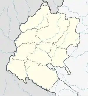
Bungal is a municipality located in Bajhang District of Sudurpashchim province of Nepal.[2] It is surrounded by Darchula District in the west, Baitadi District in the south, Surma, Chabispathivera, Durgathali, Kedarseu and Bithadchir in the East and Saipal touches it from the North.[1]
Bungal | |
|---|---|
 Bungal  Bungal | |
| Coordinates: 29.58°N 80.87°E | |
| Country | Nepal |
| Province | Sudurpaschim |
| District | Bajhang |
| No. of wards | 11 |
| Established | 10 March 2017 |
| Incorporated (VDC) | Dahbagar, Khidatari, Deulikot, Pipalkot and Kaflaseri[1] |
| Admin HQ. | Khiratadi |
| Government | |
| • Type | Mayor–council |
| • Body | Bungal Municipality |
| • Mayor | Mr. Dhan Bahadur Bishta |
| • Deputy Mayor | Mrs. Mina Bohra Jagri |
| Area | |
| • Total | 447.59 km2 (172.82 sq mi) |
| Population (2011)[1] | |
| • Total | 33,224 |
| Human Development Index | |
| • Literacy | 51.64 [1] |
| Time zone | UTC+05:45 (NPT) |
| Website | bungalmun |
On 10 March 2017 Government of Nepal announced 744 local level units as per the new constitution of Nepal 2015. [3] thus this local level unit came into existence. Total area of the municipality is 447.59 square kilometres (172.82 sq mi) and total population of the municipality (according to 2011 Nepal census) is 33224. The municipality is divided into 11 wards. Dahbagar, Khidatari, Deulikot, Pipalkot and Kaflaseri are the previous villages which were merged to form this new local level unit. [1]
References
- "Bajhang District (Municipality profile)" (PDF). www.cbs.gov.np (in Nepali). Central Bureau of Statics. 2018. p. 102. Retrieved 9 February 2020.
- "Bungal municipality". Retrieved 4 February 2020.
- "New local level structure comes into effect from today". www.thehimalayantimes.com. The Himalayan Times. 10 March 2017. Retrieved 17 July 2018.
External links
- http://mofald.gov.np/sites/default/files/News_Notices/Final%20District%201-75%20Corrected%20Last%20for%20RAJPATRA.pdf
- https://web.archive.org/web/20180831065451/http://103.69.124.141/
- http://kathmandupost.ekantipur.com/news/2017-08-11/govt-prepares-to-add-9-more-local-levels-in-province-2.html
- https://www.citypopulation.de/php/nepal-mun-admin.php?adm2id=6802
Headquarters: Jayaprithvi | ||
| Municipalities | 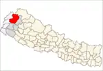 | |
| Rural municipalities | ||
| Former VDCs |
| |
List of municipalities and rural municipalities of Nepal | ||
