Baitadi District
Baitadi District (Nepali: बैतडी जिल्ला ![]() Listen ), historical name “Bairath” (बैराथ), a part of Sudurpashchim Province, is one of the 77 districts of Nepal. It is a Hill district. Baitadi, with Dasharathchand as its headquarters, covers an area of 1,519 km2 (586 sq mi) and has a population of 250,898 according to the census (2011).[1] The Baitadi district entails 56 village development councils (VDCs) and two municipality. Baitadi falls into the farthest western regional district of Nepal touching Jhulaghat, India, Nepal's neighboring country, to its border.
Listen ), historical name “Bairath” (बैराथ), a part of Sudurpashchim Province, is one of the 77 districts of Nepal. It is a Hill district. Baitadi, with Dasharathchand as its headquarters, covers an area of 1,519 km2 (586 sq mi) and has a population of 250,898 according to the census (2011).[1] The Baitadi district entails 56 village development councils (VDCs) and two municipality. Baitadi falls into the farthest western regional district of Nepal touching Jhulaghat, India, Nepal's neighboring country, to its border.
Baitadi District
बैतडी | |
|---|---|
District | |
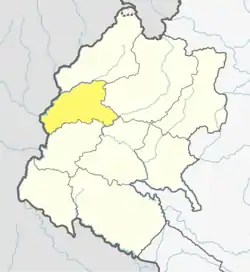 Location of Baitadi District | |
| Country | |
| Province | Sudurpashchim Province |
| Established | pre 1962 |
| Admin HQ. | Dasharathchand |
| Government | |
| • Type | Coordination committee |
| • Body | DCC, Baitadi |
| Area | |
| • Total | 1,519 km2 (586 sq mi) |
| Population (2011)[1] | |
| • Total | 250,898 |
| • Density | 170/km2 (430/sq mi) |
| Time zone | UTC+05:45 (NPT) |
| Telephone Code | 095 |
| Main Language(s) | Baitadeli |
History
Baitadi was part of Kumaon Kingdom until gorkha invasion of Kumaon in 1791,[2][3][4] the region once a part of the Great Katyuri's Kingdom. After the fall of that Kingdom, around the 10th century, Khas King Ashok Challa of Sapadalaksh (Karnali Zone or Dullu, Dailekh) seized most of that part of the Katyuri's Kingdom, including Baitadi. There were three major centres of Khas King i.e., (1) Bairath (Baitadi) (2) Kamadesh (kali kumaun) and (3) Kedarbhumi (Garhwal) to rule in a Central Himalaya .[5] According to the historical folk-tales in Baitadi it was one of the Chand Kings who fought with the Khas king and established a sovereign state for the Chand dynasty in Baitadi.[6] These tales resembled a historical story of the establishment of Kumaun Kingdom. One of the view of the historians of Uttarakhand, a state in India, Nepal's neighboring country, suggest that it was Thohar Chand who was responsible for establishing the Chand dynasty in Kali-Kumaun. He then changed his name to Abhai Chand after he became a King. Badri Dutt Pandey written history of Kumaun book has quoted the following story about the history of Kumaun.[2]
Gyan Chand (1376 A.D) was the first ruler of the Chand Dynasty of Champawat who was part of the third generation from Thohar Chand or Abhai Chand.[7] Gyan Chand's grandfather, Trilok Chand, and his father, Kalyan Chand, were rulers of Baitadi, according to the folk tales.[8]
Rulers:
The Name of the Kings who ruled in Baitadi were:
|
|
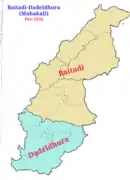
Gorkha kingdom annexed Kumaon in 1791[9][3] and merged baitadi in Doti District until 1885. Baitadi and Dadeldhura had same "Bada-Hakim" (District Administrators) so those two districts jointly used to call Baitadi-Dadeldhura district until 1956. The "Baitadi-Dadeldhura" district named Mahakali District after 1956. In 1956 four county (Thums) of Baitadi separated and made a sub-district of Mahakali district. From 1956 to 1962 "Mahakali district" had three sub-districts.[10][11][12]
- Dadeldhura
- Baitadi
- Chamba
In 1962, Darchula (Chamba) separated from Baitadi District.
- District in different time
 Darchula as a part of Baitadi sub-district of Mahakali (Baitadi-Dadeldhura) district (before 1956)
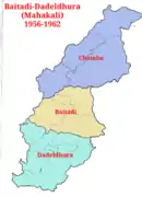 Darchula (Chamba), a sub-district of Mahakali district (1956-1962)
Demographics
According to the 2011 census, Baitadi District has a population of 250,898, with an absentee population of 21,038, roughly equal to that of the nation of Vanuatu. Baitadi District has a sex ratio of 87:95 of which 133,491 are female.,[1] The largest ethnic group is Khas/Chhetri make 76% of total population. Bahun, Thakuri and sanyasi/giri makes 21% khas dalit make 3%. of total population.
At the time of the 2011 Nepal census, 97.7% of the population in the district spoke Baitadeli, 1.0% Nepali and 0.8% Doteli as their first language.[13]
Geography and climate
| Climate Zone[14] | Elevation Range | % of Area |
|---|---|---|
| Upper Tropical | 300 to 1,000 meters 1,000 to 3,300 ft. |
13.1% |
| Subtropical | 1,000 to 2,000 meters 3,300 to 6,600 ft. |
71.2% |
| Temperate | 2,000 to 3,000 meters 6,400 to 9,800 ft. |
15.7% |
Administration
The district is administered by District Coordination Committee (Legislative), District Administration Office (Executive) and District Court (Judicial) as follows:
| Administration | Name of units | Head | Website |
|---|---|---|---|
| Legislative | District Coordination Committee | ddcbaitadi | |
| Executive | District Administration Office | Mr. Anand Paudel | daobaitadi |
| Judicial | District Court | Mr. Ishwari Prasad Bhandari | supremecourt |
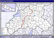
Administrative Divisions
The district consists of ten municipalities, out of which four are urban municipalities and three are rural municipalities. These are as follows:[15]
- Dasharathchand Municipality
- Patan Municipality
- Melauli Municipality
- Purchaudi Municipality
- Sunarya Rural Municipality
- Sigas Rural Municipality
- Shivanath Rural Municipality
- Pancheshwor Rural Municipality
- Dogdakedar Rural Municipality
- Dilasaini Rural Municipality
Former Village Development Committees
Prior to the restructuring of the district, Baitadi District consisted of the following municipalities and Village development committees:
- SALENA
- Amchoura
- FYAULI
- Barakot
- khadeni
- Basantapur
- Basuling
- Bhatana
- Bhumeshwar
- Bijayapur
- Bisalpur
- Bumiraj
- Nwadeu
- Chaukham
- Sibnath
- Dehimandau
- Deulek
- Dhungad
- Dilasaini
- Durga Bhabani
- Durgasthan
- Gurukhola
- Gajari
- Giregada
- Gokuleshwar
- Gwallek
- Hat
- Hatairaj
- Jagannath
- Kailpal
- Kataujpani
- Kotila
- Kotpetara
- Kulau
- Kuwakot
- Mahadevsthan
- Mahakali
- Maharudra
- Malladehi
- Nagarjun
- Siddheshwar
- Sharmali
- Raudidewal
- Rauleshwar
- Giregada
- Srikedar
- Srikot
- Sankarpur
- Shikarpur
Sports
Cricket is a very popular sport in Baitadi, and Baitadi has won many regional competitions; It is home to many eminent national players for the Nepal national cricket team.
Communication
Saugaat FM 103.6 MHz,[16] Samsher, FM 106.6 MHz and Ninglashaini FM 94.0 MHz[17] are the radio stations of the Baitadi District. Radio Pura Sanchar 97.0 MHz is also in the Baitadi District.
Agriculture
Corn and wheat are the main crops of this region, but millet, maize and rice are also grown for home use. Commercial farming is not popular in this region. Some fruits are grown and exported to the nearby headquarters Bhimdatta and Dhangadhi—particularly Mandarins, Oranges, Lemons, and sometimes Emblica. The latter is found both domesticated and growing wild in the forests. Sapindus or Soapnut is also grown and used for washing clothes as well a bodies. Sapindus is also exported to nearby towns.
References
- "National Population and Housing Census 2011(National Report)" (PDF). Central Bureau of Statistics. Government of Nepal. November 2012. Archived from the original (PDF) on 2013-04-18. Retrieved November 2012. Check date values in:
|access-date=(help) - Jha, Hari Bansh (1993). The Terai Community and National Integration in Nepal. Centre for Economic & Technical Studies.
- Atkinson, Edwin T. (Edwin Thomas), 1840-1890. (1990). Himalayan Gazetter. Cosmo. OCLC 183008777.CS1 maint: multiple names: authors list (link)
- Alter, Andrew. Mountainous Sound Spaces : Listening to History and Music in the Uttarakhand Himalayas. ISBN 978-93-84463-06-9. OCLC 899733017.
- A New History of Uttarakhand page 62
- History of Doti Kingdom page 212
- Chand Kings of Champawat : Dr. Madan Chandra Bhatt
- History of Doti Kingdom : Bhoj Raj Bhattarai
- "M. Gaborieau on 7 Bharats recorded in Nepal (1969)". Retrieved 18 February 2020.
- "Government of Nepal Act 1948" (PDF).
- "प्रशासकीय पुनर्गठन समिति (बुच कमिशन) को प्रतिवेदन, २००९" (PDF).
- "नेपालको जिल्ला प्रशासन पुनर्गठनको रिपोर्ट, २०१३" (PDF).
- 2011 Nepal Census, Social Characteristics Tables
- The Map of Potential Vegetation of Nepal - a forestry/agroecological/biodiversity classification system (PDF), . Forest & Landscape Development and Environment Series 2-2005 and CFC-TIS Document Series No.110., 2005, ISBN 87-7903-210-9, retrieved Nov 22, 2013
- "स्थानिय तह" (in Nepali). Ministry of Federal Affairs and General Administration. Archived from the original on 31 August 2018. Retrieved 1 September 2018.
- "Saugaat, FM 103.6 MHz".
- "Ninglashaini FM 94.0 MHz".
Sources
- "Districts of Nepal". Statoids.
- A New History Of Uttarakhand : Dr. Y. S. Kathoch
- History of Doti Kingdom : Bhattarai
- Spell Change amchour from amchoura by uttam chand
Places adjacent to Baitadi District | |
|---|---|
Headquarters: Dasharathchand | ||
| Municipalities | 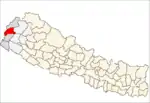 | |
| Rural municipalities | ||
| Former VDCs |
| |
List of municipalities and rural municipalities of Nepal | ||
| Wikimedia Commons has media related to Baitadi District. |