Burhakaba
Burhakaba (Somali: Buurhakaba) is a town located in the Bay region in Somalia.
Buur Hakaba | |
|---|---|
Town | |
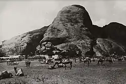 Bur Hakaba in 1928 | |
| Nickname(s): Hakaba | |
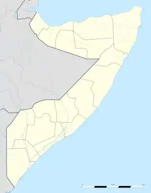 Buur Hakaba Location Bay region in Somalia. | |
| Coordinates: 2°47′0″N 44°5′0″E | |
| Country | |
| Region | Bay |
| District | Burhakaba District |
| Government | |
| • Mayor | Abdi Mohamed |
| Elevation | 643 ft (196 m) |
| Population (2014)estimated | |
| • Total | 197,198 |
| Time zone | UTC+3 (EAT) |
| Area code(s) | +2526 |
| Website | buurhakaba |
The town is named after a large mountain located at the center of the city.
Overview
Burhakaba is the second largest town in the Bay region, with a reported population of 197,198.[1] It is 180 km northwest of the capital Mogadishu and 60 km southeast from the regional center Baidoa. Burhakaba administrative district encompasses nearly 400 villages. The town is estimated to have been settled six centuries ago.[2] Burhakaba is subdivided into several administrative villages: Waaberi, Wadajir and Hoolwadaag.
Geography and demographics
Burhakaba is situated at the coordinates of 2.7991° N, 44.0794° E with an elevation of 196 meters above sea level. It does not have a permanent river but it has a large valley known as "Bohol Wiinti" that crosses the town from the north, the east and south-east. This valley supports farming in the area it drains after the seasonal rainfall. The town is estimated to have an annual rainfall of 550-620mm. Demographically the town is mainly settled by Eelaay a sub-clan of Rahanweyn and Waalmuge. The main language spoken in the town is the cushitic Maay language
Even though not fully explored, Burhakaba is believed to have huge mineral and rock deposits including uranium (in Aliyow Geele area), iron, aluminum, phosphorus, kaolin, bauxite, granite, marbles, sandstones, crushed rocks, and limestone.[3] Burhakaba has a strategic advantage in that it connects the three regions of Bakool, Hiiraan and lower shabelle
Climate
Buurhakaba has a hot and semi-arid climate (Köppen BSh), as with much of southern Somalia.It has a hot semi-arid climate. The average mean temperature is 27.5C°, but the temperature can reach as high as 36C° to 39C° in December and January. By contrast, towns in the northern part of the country generally have a hot arid climate (Köppen BWh).[4]
| Climate data for Buurhakaba/Baidoa | |||||||||||||
|---|---|---|---|---|---|---|---|---|---|---|---|---|---|
| Month | Jan | Feb | Mar | Apr | May | Jun | Jul | Aug | Sep | Oct | Nov | Dec | Year |
| Record high °C (°F) | 44.0 (111.2) |
43.0 (109.4) |
43.0 (109.4) |
43.0 (109.4) |
40.3 (104.5) |
39.5 (103.1) |
37.0 (98.6) |
38.0 (100.4) |
39.0 (102.2) |
40.0 (104.0) |
44.0 (111.2) |
45.0 (113.0) |
45.0 (113.0) |
| Average high °C (°F) | 34.3 (93.7) |
35.7 (96.3) |
35.8 (96.4) |
34.1 (93.4) |
31.5 (88.7) |
30.4 (86.7) |
28.8 (83.8) |
29.3 (84.7) |
30.8 (87.4) |
30.9 (87.6) |
31.5 (88.7) |
32.9 (91.2) |
32.1 (89.8) |
| Daily mean °C (°F) | 27.2 (81.0) |
28.0 (82.4) |
28.3 (82.9) |
27.5 (81.5) |
26.1 (79.0) |
25.1 (77.2) |
24.0 (75.2) |
24.3 (75.7) |
25.2 (77.4) |
25.5 (77.9) |
26.1 (79.0) |
26.6 (79.9) |
26.2 (79.2) |
| Average low °C (°F) | 19.9 (67.8) |
20.3 (68.5) |
20.9 (69.6) |
21.0 (69.8) |
20.8 (69.4) |
20.0 (68.0) |
19.3 (66.7) |
19.4 (66.9) |
19.7 (67.5) |
20.4 (68.7) |
20.2 (68.4) |
20.2 (68.4) |
20.2 (68.4) |
| Record low °C (°F) | 14.3 (57.7) |
15.4 (59.7) |
16.0 (60.8) |
15.0 (59.0) |
14.0 (57.2) |
17.0 (62.6) |
15.0 (59.0) |
10.0 (50.0) |
15.0 (59.0) |
15.0 (59.0) |
16.0 (60.8) |
15.5 (59.9) |
10.0 (50.0) |
| Average precipitation mm (inches) | 1 (0.0) |
6 (0.2) |
23 (0.9) |
151 (5.9) |
118 (4.6) |
12 (0.5) |
19 (0.7) |
7 (0.3) |
13 (0.5) |
141 (5.6) |
80 (3.1) |
14 (0.6) |
585 (23.0) |
| Average precipitation days (≥ 0.1 mm) | 0 | 1 | 3 | 11 | 7 | 3 | 4 | 2 | 2 | 10 | 7 | 2 | 52 |
| Average relative humidity (%) | 59 | 58 | 60 | 70 | 75 | 70 | 71 | 67 | 64 | 72 | 74 | 67 | 67 |
| Mean monthly sunshine hours | 288.3 | 274.0 | 275.9 | 228.0 | 238.7 | 207.0 | 161.2 | 207.7 | 219.0 | 192.2 | 237.0 | 275.9 | 2,804.9 |
| Mean daily sunshine hours | 9.3 | 9.7 | 8.9 | 7.6 | 7.7 | 6.9 | 5.2 | 6.7 | 7.3 | 6.2 | 7.9 | 8.9 | 7.7 |
| Percent possible sunshine | 78 | 81 | 73 | 62 | 63 | 56 | 42 | 55 | 60 | 52 | 66 | 75 | 64 |
| Source 1: Deutscher Wetterdienst[5] | |||||||||||||
| Source 2: Food and Agriculture Organization: Somalia Water and Land Management (percent sunshine)[6] | |||||||||||||
Economy
Given its strategic location, Burhakaba is a hub for livestock trading. Business people from the regions around it come to this town on Mondays mostly to trade livestock. Agricultural products also heavily contribute to the GDP of the town. For the past ten years, cultivating has been shifted from mainly crops to crops, vegetables and fruits. The economic activity is highest on Mondays as compared to other days in the week. Modern services such as telecommunications, internet services and shopping centers are also available.
Health
Burhakaba has two hospitals ( Hakaba Referral Hospital and Falsan Medical Center) and two MCHs (BTSC and the Burhakaba) which mainly carry nutrition support in a mandated form. Pregnant women in the town do not visit it as antenatal or post-natal care. It also has a T.B. center and dozens of unregistered pharmacies and clinics. The town experienced cholera epidemics several times that claimed the lives of hundreds of people.
Education
Burhakaba has five primary and secondary schools (Dr. Ayub Sheekh Yarow, Amar Bibu-Yasir, Imamu-Shafici, Zaad and Albushra) and two primary and intermediate schools (Waberi and And Imamu-Nawawi) as well as dozens of madaris. there are two institutions; Banooda Institute of Science and Technology and Najuum international Collage. The town has no university.
Notable residents
1- Prof-Mohamed Osman Jawari- He is a former Speaker of the Federal Parliament of Somalia and current MPS. He also briefly served as acting President of Somalia in August and September 2012.
2- Hon-Ali Alio Mohamed-former minister of Agriculture-1967-1969.
3-Hon- Fawzia Mohamed Sheikh-Current Minister of Energy and Water Resources-2020.
4-Sheikh Yarow Abdio Haider- Former member of parliament during siad barre regime.
5-Dr Hassan Mohamed Abdi{DR samatar} is doctor who are specialized gyno &obes now he is working ankra general hospital Ankara turky.
6. Dr Abdullahi Isak Ibrahim {Dr malaay}is a doctor who specialized in nutrition and food science and he had graduated from university of South Asia in Dhaka, Bangladesh. Now he is working for world health organization. He is freedom activist as well as former Governor of Gedo region.
References
- bevölkerungsstatistik.de
- Peel, M. C.; Finlayson B.L. & McMahon, T. A. (2007). "Updated world map of the Köppen–Geiger climate classification". Hydrol. Earth Syst. Sci. 11: 1633–1644. doi:10.5194/hess-11-1633-2007. ISSN 1027-5606. (direct: Final Revised Paper)
- "Klimatafel von Iscia Buurhakaba / Somalia" (PDF). Baseline climate means (1961-1990) from stations all over the world (in German). Deutscher Wetterdienst. Retrieved 4 November 2016.
- "Long term mean monthly sunshine fraction in Somalia". Food and Agriculture Organization. Archived from the original on 5 October 2016. Retrieved 4 November 2016.
