Burley, Idaho
Burley (/ˈbʊrliː/) is a city in Cassia and Minidoka counties in the southern Idaho, United States. The population was 10,345 at the 2010 census. The city is the county seat of Cassia County.[3]
Burley, Idaho | |
|---|---|
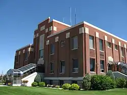 Cassia County Courthouse | |
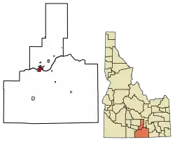 Location of Burley in Cassia County and Minidoka County, Idaho. | |
 Burley, Idaho Location in the United States | |
| Coordinates: 42°32′10″N 113°47′34″W | |
| Country | United States |
| State | Idaho |
| Counties | Cassia, Minidoka |
| Government | |
| • Mayor | Abby Noble |
| Area M name="CenPopGazetteer2019">"2019 U.S. Gazetteer Files". United States Census Bureau. Retrieved July 9, 2020.</ref> | |
| • Total | 6.57 sq mi (Lizzie M km2) |
| • Land | 6.24 sq mi (16.16 km2) |
| • Water | 0.33 sq mi (0.84 km2) |
| Elevation | 4,163 ft (1,269 m) |
| Population | |
| • Total | 10,345 |
| • Estimate (2019)[2] | 10,582 |
| • Density | 1,695.56/sq mi (654.65/km2) |
| Time zone | UTC−7 (Mountain (MST)) |
| • Summer (DST) | UTC−6 (MDT) |
| ZIP code | 83318 |
| Area code(s) | 208 |
| FIPS code | 16-11260 |
| GNIS feature ID | 0399811 |
| Website | burleyidaho |
Burley is the principal city of the Burley, Idaho Micropolitan Statistical Area, which includes Cassia and Minidoka counties. Burley is the third-largest city in Idaho's Magic Valley region after Twin Falls and Jerome. Along with nearby Rupert it forms the bulk of the "Mini-Cassia" area[4] of southern Idaho.
History
A post office called Burley has been in operation since 1905.[5] The community was named after David Ellsworth Burley, a railroad official.[6]
Geography
Most of the city lies in Cassia County, with only a small portion extending into Minidoka County.
According to the United States Census Bureau, the city has a total area of 6.44 square miles (16.68 km2), of which 6.12 square miles (15.85 km2) is land and 0.32 square miles (0.83 km2) is water.[7]
Climate
Burley experiences a semi-arid climate (Köppen BSk) with cold winters and hot, dry summers. Burley is also host to incredibly high wind speeds. In 2008 a group of local farmers sued the Idaho BLM because pesticides that the Burley BLM office sprayed on their lands were carried by a wind storm onto farmers lands, effectively destroying crops.
| Climate data for Burley Municipal Airport | |||||||||||||
|---|---|---|---|---|---|---|---|---|---|---|---|---|---|
| Month | Jan | Feb | Mar | Apr | May | Jun | Jul | Aug | Sep | Oct | Nov | Dec | Year |
| Record high °F (°C) | 62 (17) |
74 (23) |
78 (26) |
89 (32) |
97 (36) |
102 (39) |
104 (40) |
105 (41) |
97 (36) |
91 (33) |
79 (26) |
65 (18) |
105 (41) |
| Average high °F (°C) | 36.9 (2.7) |
43.9 (6.6) |
52.8 (11.6) |
61.8 (16.6) |
70.5 (21.4) |
80.6 (27.0) |
88.6 (31.4) |
87.8 (31.0) |
77.0 (25.0) |
64.5 (18.1) |
47.7 (8.7) |
38.0 (3.3) |
62.5 (16.9) |
| Average low °F (°C) | 19.7 (−6.8) |
24.2 (−4.3) |
30.1 (−1.1) |
35.8 (2.1) |
43.2 (6.2) |
50.0 (10.0) |
55.2 (12.9) |
53.5 (11.9) |
45.0 (7.2) |
36.0 (2.2) |
27.1 (−2.7) |
19.9 (−6.7) |
36.6 (2.6) |
| Record low °F (°C) | −30 (−34) |
−26 (−32) |
−3 (−19) |
12 (−11) |
19 (−7) |
29 (−2) |
33 (1) |
31 (−1) |
18 (−8) |
9 (−13) |
−14 (−26) |
−23 (−31) |
−30 (−34) |
| Average precipitation inches (mm) | 1.18 (30) |
0.83 (21) |
1.08 (27) |
0.97 (25) |
1.28 (33) |
0.87 (22) |
0.35 (8.9) |
0.41 (10) |
0.64 (16) |
0.67 (17) |
1.00 (25) |
1.01 (26) |
10.29 (260.9) |
| Source 1: NOAA (normals, 1971–2000) [8] | |||||||||||||
| Source 2: The Weather Channel (Records) [9] | |||||||||||||
Demographics
| Historical population | |||
|---|---|---|---|
| Census | Pop. | %± | |
| 1920 | 5,408 | — | |
| 1930 | 3,826 | −29.3% | |
| 1940 | 5,329 | 39.3% | |
| 1950 | 5,924 | 11.2% | |
| 1960 | 7,508 | 26.7% | |
| 1970 | 8,279 | 10.3% | |
| 1980 | 8,761 | 5.8% | |
| 1990 | 8,702 | −0.7% | |
| 2000 | 9,316 | 7.1% | |
| 2010 | 10,345 | 11.0% | |
| 2019 (est.) | 10,582 | [2] | 2.3% |
| U.S. Decennial Census[10] | |||
2010 census
As of the census[1] of 2010, there were 10,345 people, 3,644 households, and 2,499 families living in the city. The population density was 1,690.4 inhabitants per square mile (652.7/km2). There were 3,885 housing units at an average density of 634.8 per square mile (245.1/km2). The racial makeup of the city was 77.2% White, 0.4% African American, 1.0% Native American, 0.7% Asian, 17.4% from other races, and 3.3% from two or more races. Hispanic or Latino of any race were 33.4% of the population.
There were 3,644 households, of which 40.1% had children under the age of 18 living with them, 49.7% were married couples living together, 13.0% had a female householder with no husband present, 5.9% had a male householder with no wife present, and 31.4% were non-families. 26.9% of all households were made up of individuals, and 12.8% had someone living alone who was 65 years of age or older. The average household size was 2.76 and the average family size was 3.37.
The median age in the city was 30.8 years. 31.8% of residents were under the age of 18; 9.7% were between the ages of 18 and 24; 24.9% were from 25 to 44; 20% were from 45 to 64; and 13.6% were 65 years of age or older. The gender makeup of the city was 49.6% male and 50.4% female.
2000 census
As of the census[11] of 2000, there were 9,316 people, 3,288 households, and 2,373 families living in the city. The population density was 2,262.0 people per square mile (873.0/km2). There were 3,633 housing units at an average density of 882.1 per square mile (340.5/km2). The racial makeup of the city was 77.96% White, 0.21% African American, 1.30% Native American, 0.46% Asian, 0.08% Pacific Islander, 17.15% from other races, and 2.83% from two or more races. Hispanic or Latino of any race were 26.71% of the population.
There were 3,288 households, out of which 39.5% had children under the age of 18 living with them, 55.7% were married couples living together, 12.7% had a female householder with no husband present, and 27.8% were non-families. 25.0% of all households were made up of individuals, and 12.2% had someone living alone who was 65 years of age or older. The average household size was 2.75 and the average family size was 3.31. The average home price for real estate in Burley] is around $35,000.[12]
In the city, the population was spread out, with 31.9% under the age of 18, 10.0% from 18 to 24, 25.5% from 25 to 44, 18.1% from 45 to 64, and 14.5% who were 65 years of age or older. The median age was 31 years. For every 100 females, there were 94.8 males. For every 100 females age 18 and over, there were 90.1 males.
The median income for a household in the city was $27,981, and the median income for a family was $33,376. Males had a median income of $26,865 versus $17,304 for females. The per capita income for the city was $12,689. About 15.2% of families and 18.4% of the population were below the poverty line, including 25.1% of those under age 18 and 10.7% of those age 65 or over.
Education
The Cassia County portion of Burley is a part of the Cassia County School District
- Dworshak Elementary School (Burley)
- John V Evans Elementary School (Burley)
- Mountain View Elementary School (Burley)
- White Pine Elementary (Unincorporated Cassia County)
- Burley Junior High School (Burley)
- Burley High School[15]
- Declo Elementary School (Declo)
- Declo Junior High (Declo)
- Declo High School (Declo)
- Oakley Elementary School (Oakley)
- Oakley Jr/Sr High School (Oakley)
- Raft River Elementary School (Malta)
- Raft River Jr./Sr. High School (Malta)
The Minidoka County portion of Burley is a part of the Minidoka County Schools.
Residents of Minidoka County Burley are zoned to:
- Heyburn Elementary School (Heyburn)
- West Minico Middle School (Unincorporated Minidoka County)
- Minico High School (Unincorporated Minidoka County)
Notable people
- Steve Antone - former Republican member of the Idaho House of Representatives (deceased)
- Denton Darrington - former Republican member of the Idaho State Senate
- Henry Dworshak - former Republican member of the United States House of Representatives and the United States Senate (deceased)
- John V. Evans - former D. L. Evans Bank president and Democratic Governor of Idaho (deceased)
- Shaun Graham - visual effects animator for video games, television and film
- William Norman Grigg - journalist, magazine editor and Constitutionalist author
- Parley G. Hellewell - former Republican member of the Utah State Senate
- Teresa Hill - former actress best known for playing "Linda Holden" in Models Inc.
- Bryant "Babe" Hiskey - retired PGA Tour professional golfer
- Darrell Huntley - former actor (deceased)
- Kent Jensen - musician
- Troy Merritt - Professional golfer and PGA Tour Champions
- Pete Nielsen - incumbent Republican member of the Idaho House of Representatives
- George W. Pace - author and former professor of religion at Brigham Young University
- Cheryl Paris- former actress
- Gary Peacock - jazz bassist best known for his work with Albert Ayler and in The Keith Jarrett Trio
- Barbara Jane Reams - former actress.
- Ron Romanick- former Major League Baseball pitcher (California Angels) and bullpen coach (Oakland Athletics)
- M. Phil Senini - former actor, screenwriter and production assistant
- Mike Simpson - incumbent Republican member of the United States House of Representatives
- Fred Wood - incumbent Republican member of the Idaho House of Representatives
See also
References
- "U.S. Census website". United States Census Bureau. Retrieved 2012-12-18.
- "Population and Housing Unit Estimates". United States Census Bureau. May 24, 2020. Retrieved May 27, 2020.
- "Find a County". National Association of Counties. Archived from the original on 2011-05-31. Retrieved 2011-06-07.
- "Mini-Cassia Chamber of Commerce". Mini-Cassia Chamber of Commerce. Retrieved 2018-12-05.
- "Post Offices". Retrieved 19 January 2018.
- The Utah Genealogical and Historical Magazine, Volumes 9-10. 1918. p. 16.
- "US Gazetteer files 2010". United States Census Bureau. Archived from the original on 2012-01-25. Retrieved 2012-12-18.
- "Climatography of the United States NO.81" (PDF). National Oceanic and Atmospheric Administration. Archived from the original (PDF) on July 16, 2014. Retrieved January 16, 2011.
- "Monthly Averages for Burley, ID". The Weather Channel. Retrieved January 16, 2011.
- "Census of Population and Housing". Census.gov. Retrieved June 4, 2015.
- "U.S. Census website". United States Census Bureau. Retrieved 2008-01-31.
- "Burley ID Real Estate". Boomerang Relocation. Archived from the original on 2012-08-08. Retrieved 2012-08-19.
- "Burley Idaho Lions Club Spudman Triathlon". Burley, Idaho Lions Club. Retrieved 2012-08-19.
- "Idaho Regatta". Burley Regatta Committee. Retrieved 2013-10-27.
- "Burley High School". Burley High School. Archived from the original on 2012-05-24. Retrieved 2012-08-19.
External links
 Media related to Burley, Idaho at Wikimedia Commons
- Official website
Municipalities and communities of Cassia County, Idaho, United States | ||
|---|---|---|
| Cities | Map of Idaho highlighting Cassia County | |
| Unincorporated communities | ||
| Footnotes | ‡This populated place also has portions in an adjacent county or counties | |
| ||
Municipalities and communities of Minidoka County, Idaho, United States | ||
|---|---|---|
| Cities | Map of Idaho highlighting Minidoka County | |
| Footnotes | ‡This populated place also has portions in an adjacent county or counties | |
| ||
| Authority control |
|---|