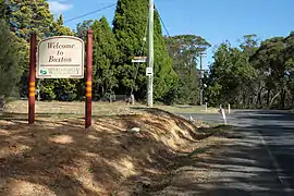
Buxton, New South Wales
Buxton is a small village in Macarthur Region of New South Wales, Australia, in Wollondilly Shire. At the 2016 census, Buxton had a population of 2,028 people.[1] Its name comes from the town of Buxton, Derbyshire. [2]
| Buxton New South Wales | |||||||||||||||
|---|---|---|---|---|---|---|---|---|---|---|---|---|---|---|---|
 East Parade, Buxton, looking south | |||||||||||||||
| Population | 2,028 (2016 census)[1] | ||||||||||||||
| Postcode(s) | 2571 | ||||||||||||||
| LGA(s) | Wollondilly Shire | ||||||||||||||
| Region | Macarthur | ||||||||||||||
| State electorate(s) | Wollondilly | ||||||||||||||
| Federal Division(s) | Hume | ||||||||||||||
| |||||||||||||||
Geography
It is bordered by Couridjah to the north, Thirlmere Lakes National Park to the West, Balmoral to the South and Bargo State Recreation Area to the east. The two main roads and the railway line run north-south and development has extended generally east towards Bargo River Gorge.
Population
In the 2016 Census, there were 2,028 people in Buxton. 85.2% of people were born in Australia and 92.8% of people spoke only English at home. The most common responses for religion were Anglican 30.8%, Catholic 25.6% and No Religion 25.1%.[1]
Education
Buxton Public School is situated on Hassall Road at the northern extent of the village. Secondary school students travel by bus to Picton High School, Wollondilly Anglican College, or to schools in the Southern Highlands, e.g. Bowral High School and Chevalier College. Buxton Public School has an enrolment of approximately 200 students.
Buxton School of Arts Hall on West Parade, hosts Playgroups, an Art Group and has a Community Garden at the rear of the property. It also is available to hire by community groups, businesses and for social occasions.
Railway
The village developed around a railway station, established in 1883, and later crossing loop on the former Main Southern Railway. A station platform was added in 1893 (The current platform was built for RTM by the Rotary Club Of Picton Inc with the aid of the local RFS and community to help with their tourist service in the 1990s).[3] This line had gradients as steep as 1 in 30, and on 13 July 1919, the railway was deviated to the East. The new line, via Bargo, became the Main Line, and the original line became the Picton Loop line.[4]
The Loop Line was closed in 1978 due to lack of traffic, and road-bridge failure between Colo Vale and Braemar, but the section from Picton to Buxton was retained as a heritage railway, and is still operated by the NSW Rail Museum.[5]
Buxton Photo Gallery
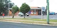
Shopping Centre, East Parade 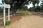
Station on Loop Line (closed) 
School of Arts Hall 
Locomotive at Buxton Station 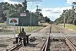
Rural Fire Brigade Shed
References
- Australian Bureau of Statistics (27 June 2017). "Buxton (NSW)". 2016 Census QuickStats. Retrieved 13 July 2017.

- Appleton, R. & B. 1992. The Cambridge Dictionary of Australian Place Names. Cambridge University Press. p. 51 ISBN 0-521-39506-2
- , NSW Rail
- Bayley (see Biblio. p 35.)
- State Rail Authority Archives Section Historical Notes 3A - Southern Branch Lines 1991
Bibliography
- Bayley, W. A. 1973. Picton-Mittagong Loop-Line Railway Bulli: Austrail. ISBN 0-909597-14-6