Razorback, New South Wales
Razorback is a locality and scattered village in the Macarthur Region of New South Wales, Australia, in the Wollondilly Shire. At the 2016 census, the locality had a population of 1,082.[1] It is in between the main Macarthur towns of Picton (to the south) and Camden (to the north).
| Razorback New South Wales | |
|---|---|
 | |
Razorback | |
| Coordinates | 34°09′03″S 150°40′47″E |
| Population | 1,082 (2016 census)[1] |
| Postcode(s) | 2571 |
| LGA(s) | Wollondilly |
| Region | Macarthur |
| State electorate(s) | Wollondilly |
| Federal Division(s) | Hume |
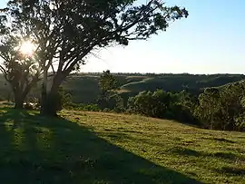
It is commonly referred to as Razorback Range as it is part range of high steep hills that make up the Macarthur Region. Furthermore, like most of the Wollondilly it is part of the hills that are in between the Blue Mountains and Southern Highlands regions.
At the top of Razorback contains a lookout which offers panoramic views of the Campbelltown-Camden urban district as well as the metropolitan Sydney as a whole.[2]
References
- Australian Bureau of Statistics (27 June 2017). "Razorback (State Suburb)". 2016 Census QuickStats. Retrieved 13 July 2017.

- "Razorback, Cawdor, Camden Park". Archived from the original on 28 February 2015.
- Villy, Elizabeth (2011). The Old Razorback Road. Rosenberg Publishing. ISBN 9781921719066.
This article is issued from Wikipedia. The text is licensed under Creative Commons - Attribution - Sharealike. Additional terms may apply for the media files.