Céou
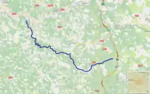
The Céou (French: le Céou) is a 55.1 km (34.2 mi) long river in the Lot and Dordogne départements, southwestern France.[1] Its source is at Séniergues, 13 km (8.1 mi) southwest of Rocamadour. It flows generally northwest. It is a left tributary of the Dordogne into which it flows at Castelnaud-la-Chapelle, 9 km (5.6 mi) southwest of Sarlat-la-Canéda.
| Céou | |
|---|---|
 | |
 | |
| Location | |
| Country | France |
| Physical characteristics | |
| Source | |
| • location | Séniergues |
| • coordinates | 44°21′24″N 01°32′47″E |
| • elevation | 275 m (902 ft) |
| Mouth | |
• location | Dordogne |
• coordinates | 44°48′50″N 01°09′15″E |
• elevation | 65 m (213 ft) |
| Length | 55.1 km (34.2 mi) |
| Basin size | 610 km2 (240 sq mi) |
| Discharge | |
| • average | 3.37 m3/s (119 cu ft/s) |
| Basin features | |
| Progression | Dordogne→ Gironde estuary→ Atlantic Ocean |
Communes along its course
This list is ordered from source to mouth:
- Lot: Séniergues, Montfaucon, Vaillac, Beaumat, Frayssinet, Saint-Chamarand, Saint-Germain-du-Bel-Air, Concorès, Dégagnac, Gourdon, Léobard, Salviac
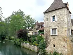
- Dordogne: Saint-Aubin-de-Nabirat, Florimont-Gaumier, Saint-Martial-de-Nabirat, Bouzic, Daglan, Cénac-et-Saint-Julien, Saint-Cybranet, Castelnaud-la-Chapelle
Notes
- This article is based on the equivalent article from the French Wikipedia, consulted on 6 May 2009.
References
This article is issued from Wikipedia. The text is licensed under Creative Commons - Attribution - Sharealike. Additional terms may apply for the media files.
