Saint-Cybranet
Saint-Cybranet is a commune in the Dordogne department in Nouvelle-Aquitaine in southwestern France.
Saint-Cybranet | |
|---|---|
 The church and war memorial in Saint-Cybran | |
 Coat of arms | |
Location of Saint-Cybranet 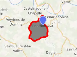
| |
 Saint-Cybranet  Saint-Cybranet | |
| Coordinates: 44°47′21″N 1°10′15″E | |
| Country | France |
| Region | Nouvelle-Aquitaine |
| Department | Dordogne |
| Arrondissement | Sarlat-la-Canéda |
| Canton | Vallée Dordogne |
| Intercommunality | Domme - Villefranche du Périgord |
| Government | |
| • Mayor (2008–2014) | Claudine Farfal |
| Area 1 | 10.33 km2 (3.99 sq mi) |
| Population (2017-01-01)[1] | 385 |
| • Density | 37/km2 (97/sq mi) |
| Time zone | UTC+01:00 (CET) |
| • Summer (DST) | UTC+02:00 (CEST) |
| INSEE/Postal code | 24395 /24250 |
| Elevation | 70–270 m (230–890 ft) (avg. 78 m or 256 ft) |
| 1 French Land Register data, which excludes lakes, ponds, glaciers > 1 km2 (0.386 sq mi or 247 acres) and river estuaries. | |
Geography
The river Céou forms part of the commune's southeastern border, then flows north-northwest through its eastern part.
Population
| Year | Pop. | ±% |
|---|---|---|
| 1962 | 288 | — |
| 1968 | 277 | −3.8% |
| 1975 | 273 | −1.4% |
| 1982 | 280 | +2.6% |
| 1990 | 310 | +10.7% |
| 1999 | 351 | +13.2% |
| 2008 | 373 | +6.3% |
See also
References
- "Populations légales 2017". INSEE. Retrieved 6 January 2020.
External links
| Wikimedia Commons has media related to Saint-Cybranet. |
| Authority control |
|
|---|
This article is issued from Wikipedia. The text is licensed under Creative Commons - Attribution - Sharealike. Additional terms may apply for the media files.