Côle
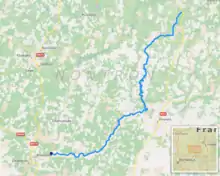
The Côle (French: la Côle) is a 51.5 km (32.0 mi) long river in the Dordogne département, south-central France.[1] It rises near le Châtenet, a hamlet in Firbeix. It flows generally southwest. It is a left tributary of the Dronne into which it flows between Condat-sur-Trincou and Brantôme.
| Côle | |
|---|---|
.JPG.webp) The Côle at Condat-sur-Trincou | |
 | |
| Location | |
| Country | France |
| Physical characteristics | |
| Source | |
| • location | Firbeix |
| • coordinates | 45°34′59″N 00°58′01″E |
| • elevation | 370 m (1,210 ft) |
| Mouth | |
• location | Dronne |
• coordinates | 45°22′08″N 00°41′05″E |
• elevation | 105 m (344 ft) |
| Length | 51.5 km (32.0 mi) |
| Basin size | 172 km2 (66 sq mi) |
| Basin features | |
| Progression | Dronne→ Isle→ Dordogne→ Gironde estuary→ Atlantic Ocean |
Communes along its course
This list is ordered from source to mouth: Firbeix, La Coquille, Mialet, Saint-Jory-de-Chalais, Saint-Romain-et-Saint-Clément, Thiviers, Saint-Jean-de-Côle, Saint-Pierre-de-Côle, La Chapelle-Faucher, Condat-sur-Trincou, Brantôme
Notes
- This article is based on the equivalent article from the French Wikipedia, consulted on 11 April 2009.
References
This article is issued from Wikipedia. The text is licensed under Creative Commons - Attribution - Sharealike. Additional terms may apply for the media files.