Saint-Jean-de-Côle
Saint-Jean-de-Côle is a commune in the Dordogne department in Nouvelle-Aquitaine in southwestern France.
Saint-Jean-de-Côle | |
|---|---|
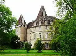
.JPG.webp) A general view of Saint-Jean-de-Côle | |
Location of Saint-Jean-de-Côle 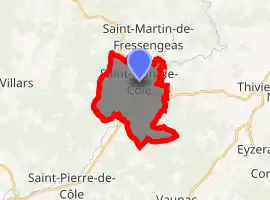
| |
 Saint-Jean-de-Côle  Saint-Jean-de-Côle | |
| Coordinates: 45°25′19″N 0°50′21″E | |
| Country | France |
| Region | Nouvelle-Aquitaine |
| Department | Dordogne |
| Arrondissement | Nontron |
| Canton | Thiviers |
| Government | |
| • Mayor (2008–2014) | Francis Sedan |
| Area 1 | 12.70 km2 (4.90 sq mi) |
| Population (2017-01-01)[1] | 365 |
| • Density | 29/km2 (74/sq mi) |
| Time zone | UTC+01:00 (CET) |
| • Summer (DST) | UTC+02:00 (CEST) |
| INSEE/Postal code | 24425 /24800 |
| Elevation | 135–252 m (443–827 ft) (avg. 149 m or 489 ft) |
| 1 French Land Register data, which excludes lakes, ponds, glaciers > 1 km2 (0.386 sq mi or 247 acres) and river estuaries. | |
Geography
The Côle flows south-southwest through the middle of the commune and crosses the village.
Population
- Views of Saint-Jean-de-Côle

.JPG.webp)
|
|
See also
References
- "Populations légales 2017". INSEE. Retrieved 6 January 2020.
| Wikimedia Commons has media related to Saint-Jean-de-Côle. |
| Authority control |
|
|---|
This article is issued from Wikipedia. The text is licensed under Creative Commons - Attribution - Sharealike. Additional terms may apply for the media files.