Calala, New South Wales
Calala is a suburb of the Northern New South Wales city of Tamworth, administered by Tamworth Regional Council. In the 2016 census,[2] Calala had a population of 3,927.
| Calala Tamworth, New South Wales | |||||||||||||||
|---|---|---|---|---|---|---|---|---|---|---|---|---|---|---|---|
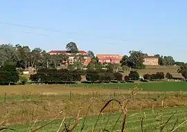 Farrer Memorial Agricultural High School | |||||||||||||||
Calala | |||||||||||||||
| Coordinates | 31°08′S 150°57′E | ||||||||||||||
| Population | 3,927 (2016 census)[1] | ||||||||||||||
| Postcode(s) | 2340 | ||||||||||||||
| LGA(s) | Tamworth Regional Council | ||||||||||||||
| State electorate(s) | Tamworth, | ||||||||||||||
| Federal Division(s) | New England | ||||||||||||||
| |||||||||||||||
The suburb is 4.5 km southeast of the CBD of Tamworth and is connected to the city by Calala Lane, which continues through the suburb to form its main street. Calala Lane often becomes flooded in times of heavy rain, usually isolating the residents from the rest of the city but generally only for several hours at a time. Further along Calala Lane past the residential area of Calala is Farrer Memorial Agricultural High School and the New South Wales Department of Agriculture plant research institute.
Commercial area
A commercial shopping complex opened in 2006 which now serves the residents of Calala. The complex contains an IGA supermarket,[3] fish and chip takeaway shop, bottle shop, butcher, pharmacy and Northwest Health GP clinic.[4] Following an extension to the complex in late 2017, a Domino's pizza outlet is also part of this shopping centre. Calala also contains a smaller shopping centre consisting of a bottle shop, a takeaway shop and a small hippie clothing and giftware store.
Schools
- Carinya Christian School
- Farrer Memorial Agricultural High School, located just outside Calala
History
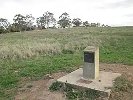
The name "Calala" originates from the local aboriginal name for this area on what is now known as the Peel River. Various anglicised spellings of this name have been used, including "Kalala", "Kilala", "Kallala, and "Callala". The first house in the Calala area, built for Charles Hall in 1834, was named "Killala".[5] An historical marker has been constructed on the northwest outskirts of Calala to recognise this construction.
References
- Australian Bureau of Statistics (27 June 2017). "Calala (State Suburb)". 2016 Census QuickStats. Retrieved 19 March 2018.

- "2016 Census QuickStats: Calala". www.censusdata.abs.gov.au. Retrieved 16 January 2018.
- http://www.carlosiga.com.au/store-locator/carlo-s-iga-calala/
- "Northwest Health - Our Locations | Health Services Catering North West NSW". northwesthealth.com.au. Retrieved 16 January 2018.
- "Tamworth and Districts Early History". www.tamworth.nsw.gov.au. 2006.