Canadian weather radar network
The Canadian weather radar network consists of 31 weather radars spanning Canada's most populated regions. Their primary purpose is the early detection of precipitation, its motion and the threat it poses to life and property.
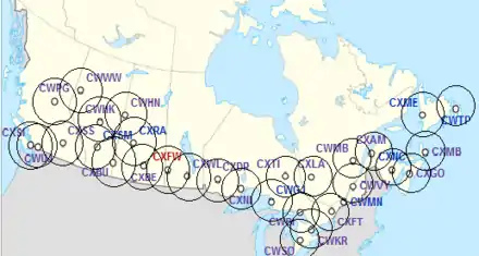
Each had until 2018 a range of 256 km (159 mi) in radius around the site to detect reflectivity, 3 angles with a range of 128 km (80 mi), for detecting velocity pattern (Doppler effect), and an extra long range up to 240 km (150 mi) at low elevation angle but strongly folded or aliased (where the maximum unambiguous velocity interval (±Vmax) is less than the full range of velocities being measured which leads to some being displayed with the wrong values[1]).
The renewal of the network, from 2018 to 2023, with new S-Band radars brings these numbers respectively to 300 km (190 mi) for reflectivity and 240 km (150 mi) for full Doppler coverage.[2] Furthermore, the new radars are dual-polarized which means precipitation type can be estimated directly.
History
Research in weather radars in Canada began at the end of the Second World War with "Project Stormy Weather".[3] After the war, J.S. Marshall continued at McGill University the work with the "Stormy Weather Group".[4] The Canadian network was thus gradually formed and by 1997, there were 19 weather radars of two kinds across the country: 18 five centimeter wavelength (C-Band) radars and 1 ten centimeter wavelength (S-Band) at McGill, all of the radars detected reflectivity and are equipped with Doppler capabilities.
Environment Canada received approval in 1998 to upgrade the network to Doppler standard and to add 12 more radars with the operational characteristics coming from King City weather radar station (CWKR), the research radar of Environment Canada.[5] However, McGill radar (at the J. S. Marshall Radar Observatory), while being part of the network, is owned by McGill University. It is a research as well as an operational radar and is modified independently. The Jimmy Lake and Lac Castor stations are owned and operated by the Department of Defense (DND), these are also part of the network.
In February 2017, the Minister of Environment and Climate Change, Catherine McKenna, announced the signature of a $83‑million contract with Selex ES to buy 20 new radars with the most modern technology available (S band and double polarized) to update the network.[6][7] The first radar was installed in Radisson, SK in the fall of 2017. The second radar was installed in the summer of 2018 at Blainville in the Montreal region to replace the aging McGill radar (WMN). 2018 will also see replacement radars at Foxwarren MB, Timmins ON ( near Smooth Rock Falls), and Spirit River AB with the rest being replaced sequentially by 2023. An additional radar will be installed in the Lower Athabasca region in Alberta and the contract also contains options to replace all radars in the Canadian Weather Radar Network, by March 31, 2023
Characteristics before 2018
- McGill radar (at the J. S. Marshall Radar Observatory):[8]
- 9 metre (30 feet) diameter antenna.
- Uses a klystron to produce a wavelength signal of 10 cm. (S-Band)
- Doppler since 1993 and dual polarization was added in 1999.
- King City weather radar station
- This research radar is essentially a WSR-98A (see below) upgraded with dual polarization capability in 2004.
- The rest of the network:[5]
- The existing radars have antennas from two manufacturers: Enterprise Electronics Corporation (EEC) and Raytheon.
- some of the existing radars have antennas produced by Andrew Canada. With a diameter almost double the old ones; resolutions improved by the same amount.
- Use 5.6 cm wavelength emitting magnetrons. (C-Band)
- Process received reflectivity and Doppler data with Sigmet Radar Data Systems, now a part of Vaisala Oyj.
- Each radar in the network will thus be called a WSR-98E, WSR-98R or WSR-98A for Weather Surveillance Radar - 1998 (for the year of the start of the program) and the first letter of the manufacturer of the Pedestal/Antenna (Enterprise, Raytheon or Andrew).
- Antennas of 3.6 metres in diameter for the ungraded radars and 6.1 m for the new ones.
- Pulse length and pulse repetition frequency adjustable. Pulse length 0.8,1.6 and 2.0s. Pulse repetition frequency (PRF) 250 Hz and Dual PRF (Doppler Mode) 1190/1200 Hz.

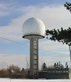 Tower and radome of McGill radar (CWMN).
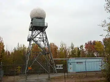 Villeroy radar (a WSR-98E), 75 km southwest of Quebec City : tower and radome to the left, transmitter and receiver in the building on the right.
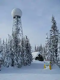 Station CXSS (a WSR-98A) at Silver Star Mountain.
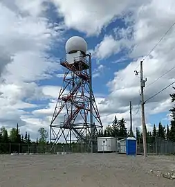 Station CXLA, a WSR-98R, of Landrienne in June 2019 with the base of its replacement in front.
Scanning strategy
Because the network is using C band radars, compromises had to be used (see Doppler dilemma) between maximum reflectivity range and maximum non ambiguous velocities. The actual scanning strategy (2006) is divided in two separate scans over 10 minutes:[5]
- Conventional cycle: 24 elevation angles scanned in 5 minutes to obtain a tri-dimensional view of the atmosphere within 256 km of the radar in reflectivity.
- Doppler cycle: 4 angles scanned in reflectivity and velocities, the first three in a range of 128 km and the last within 256 km. This cycle is used to locate possible small scale rotation and shear in the wind pattern as well as the large scale circulation. The velocity data also help to filter artifacts in the reflectivity such as ground echos.
The McGill radar uses a S-band transmitter instead of a C-band transmitter to acquire reflectivities and velocities during each of its 24 elevation angles with the same 5 minute cycle time.[8]
Modernization project
Environment and Climate Change Canada received the funding from the Treasury Board in 2011 to undergo a major modernization project called 'WES (Weather and Environmental Services) Renewal' to upgrade to dual polarization all Canadian Radars in two separate five year plans. Complete network stabilization and systemic problems resolution were also part of this major effort by Environment and Climate Change Canada. The first five years concentrated on the upgrading and stabilizing the existing radars. Then all Canadian weather radars will be replaced with a dual polarization S-band radar between 2017 and 2023. A new radar, owned and operated by ECCC, has been installed in Blainville (near Montreal) to replace the use of the McGill radar. As well, a new radar will be installed in the Lower Athabasca area. .[9]
The new radar chosen is the Selex METEOR 1700S which is fully Doppler and dual polarized:[2] · [10]
- Transmitter type: Klystron
- Frequency : 2.7 - 2.9 GHz
- Pulse repetition frequency (PRF): 250 – 2000 Hz
- Pulse length (τ): 0.4 µs ... 4.5 µs
- Peak power: 750 kW
- Doppler range: 240 km
- Reflectivity normal range: 300 km
- maximum range: 600 km
- Velocity resolution : ± 146 m/s
- Antenna diameter: 8.5 m
- Beamwidth : < 1°
- Rotation: 6 min−1
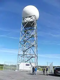 New METEOR 1700S in Blainville, Quebec.
 Transmitter's klystron.
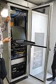 Radar processor.
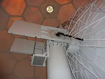 Antenna and pedestal.
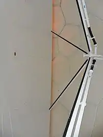 Antenna and feed horn.
These new S-Band radars offer more flexibility over the previous C-Band radars. The scanning strategy of 17 angles scanned in 6 minutes, and the new dual-polarization feature provide:[11]
- Dual polarization will permit to better differentiate the type of precipitation (rain, snow, hail and freezing rain), biological and non-biological targets such as birds, insects, chaff, and tornado debris signature.
- The radial velocity range (Doppler range) will be extended to 240 kilometres (150 mi), from 120 kilometres (75 mi), permitting an improved lead time in weather warnings issuance and a better overlap of radar coverage with other nearby radars.
List of radars
The first modernization process began in the fall of 1998 with the opening of Bethune radar and ended in 2004 with the one in Timmins. The replacement of C-band 250 kW Magnetron single-pol radars with S-band 1MW Klystron dual-pol radars began in 2017 and will end in 2023.[12]
| Site | Location | Province | Coordinates | ID/call sign | Band | Type | Callsign meaning | Notes |
|---|---|---|---|---|---|---|---|---|
| Aldergrove | Vancouver | British Columbia | 49.01662°N 122.48698°W | CWUJ | C | 98E | ||
| Bethune | Regina | Saskatchewan | 50.57118°N 105.18290°W | CASBE | S | Selex 1700S | Bethune | New radar commissioned in August 2019 replacing 98A (XBE) A temporary mobile X-band radar was deployed during the upgrade. |
| Blainville | Montréal | Québec | 45.70634°N 73.85852°W | CASBV | S | Selex 1700S | BlainVille | New radar commissioned at the end of September 2018, replacing McGill radar (CWMN).[13] |
| Britt | Georgian Bay | Ontario | 45.79317°N 80.53385°W | CWBI | C | 98A | Britt | |
| Carvel | Edmonton | Alberta | 53.56056°N 114.14495°W | CWHK | C | 98E | ||
| Chipman | Central New Brunswick | New Brunswick | 46.22232°N 65.69924°W | CASCM |
S | Selex 1700S | New Brunswick Chipman | New radar commissioned in September2019 replacing 98E (XNC) |
| Dryden | Western Ontario | Ontario | 49.85823°N 92.79698°W | CASDR | S | Selex 1700S | Dryden | Replaced C-Band CXDR on Septembre 3, in 2020. |
| Egbert (near Barrie) | Southern Ontario | Ontario | 44.2305662°N 79.7803300°W | N/A | S | Selex METEOR 1700S | N/A | New radar site for research, training, and tests of material and software. It will be built at the Centre for Atmospheric Research Experiments (CERA). |
| Exeter | Southwestern Ontario | Ontario | 43.37243°N 81.38070°W | CASET |
S | Selex 1700S | Exeter | New radar commissioned in November 2019 replacing 98A (WSO) |
| Foxwarren | Eastern Saskatchewan/Western Manitoba | Manitoba | 50.54887°N 101.08570°W | CASFW | S | Selex 1700S | Foxwarren | Radar commissioned in September 2018, replacing CXFW, a C-band radar.[14] A temporary mobile X-band radar was deployed during the upgrade until October 31, 2018.[15][16] |
| Franktown | Eastern Ontario | Ontario | 45.04101°N 76.11617°W | CXFT | C | 98A | Franktown | |
| Gore | Central Hants County | Nova Scotia | 45.09850°N 63.70433°W | CXGO | C | 98A | Gore | |
| Holyrood | Eastern Newfoundland | Newfoundland and Labrador | 47.32644°N 53.12658°W | CASHR | S | Selex METEOR 1700S | Holyrood | Commissioned on Octobre 13, 2020. Replaced the C-band (98E) CWTP. |
| Jimmy Lake | NW Saskatchewan/NE Alberta | Saskatchewan | 54.91333°N 109.95528°W | CWHN | C | 98E | ||
| King City | Southern Ontario | Ontario | 43.96393°N 79.57388°W | CWKR | C | 98A | King City Radar | |
| Lac Castor | Saguenay River | Quebec | 48.57581°N 70.66784°W | CWMB | C | 98E | ||
| Landrienne | Amos | Quebec | 48.55136°N 77.80809°W | CASLA |
S | Selex 1700S | Landrienne Amos | Radar commissioned in October 2019, replacing the previous 98R CXLA C-band radar. |
| Marble Mountain | Western Newfoundland | Newfoundland and Labrador | 48.93028°N 57.83417°W | CXME | C | 98A | Marble Mountain | |
| Marion Bridge | Southeastern Cape Breton County | Nova Scotia | 45.94972°N 60.20521°W | CASMB | S | Selex 1700S | Marion Bridge | Radar commissioned in October 2019, replacing the previous CXMB C-band radar. |
| Montreal River | Sault Ste Marie | Ontario | 47.24773°N 84.59652°W | CASMR |
S | Selex 1700S | Montreal River | Radar commissioned in November 2019, replacing the previous 98E WGJ C-band radar. |
| Mount Silver Star | Vernon | British Columbia | 50.36950°N 119.06436°W | CXSS | C | 98A | Silver Star | |
| Prince George | Northern B.C. | British Columbia | 53.61308°N 122.95441°W | CXPG | C | 98R | Prince George | |
| Radisson | Saskatoon | Saskatchewan | 52.52048°N 107.44269°W | CASRA | S | Selex 1700S | Radisson | Radar commissioned in February 2018, replacing CXRA, a C-band radar. |
| Sainte-Françoise/ (Villeroy) |
Southwest of Quebec City | Quebec | 46.449556°N 71.913831°W | CASSF | S | Selex 1700S | Sainte-Françoise | Commissioned on November 2020, replacing the C-Band CWVY with no change of site but change of name from Villeroy to Sainte-Françoise, a closer geographical point. |
| Schuler | Medicine Hat | Alberta | 50.31250°N 110.19556°W | CASSU | S | Selex 1700S | SchUler | Replacement the C-Band CXBU on Septembre 8, 2020. |
| Smooth Rock Falls | Northeastern Ontario | Ontario | 49.28146°N 81.79406°W | CASRF | S | Selex 1700S | Smooth Rock Falls (The S in CASRF is for S-Band) | Initially known as Timmins CXTI, then Northeast Ontario. Finally Smooth Rock Falls with the dual polarization upgrade Commissioned in 2018/10. |
| Spirit River | Grande Prairie | Alberta | 55.69494°N 119.23043°W | CASSR | S | Selex 1700S | Spirit River | This radar was replaced in 2018 and commissioned in Feb 2019 replacing CWWW a C-band radar that had been in operation since 2001/10 |
| Strathmore | Calgary | Alberta | 51.20613°N 113.39937°W | CASSM | S | Selex 1700S | Strathmore | Radar commissioned in November 2019, replacing the previous 98A (XSM) C-band radar. A temporary mobile X-band radar was deployed during the upgrade. |
| Superior West | Lasseter Lake | Ontario | 48.85352°N 89.12150°W | CXNI | C | 98E | Nipigon | |
| Val d'Irène | Lower St. Lawrence | Quebec | 48.48028°N 67.60111°W | CASVD | S | Selex METEOR 1700S | Val d'Irène | Replaced the C-Band CAXM (98A) radar. Commissioned on November 2, 2020. |
| Woodlands | Winnipeg | Manitoba | 50.15389°N 97.77833°W | CASWL | S | Selex METEOR 1700S | Woodlands | Replaced the C-band (98A) CXWL on October 19, 2020.[17] A temporary mobile X-band radar was deployed during the upgrade.[18] |
| Site | Location | Province | Coordinates | ID/call sign | Band | Type | Callsign meaning | Notes |
|---|---|---|---|---|---|---|---|---|
| McGill | Montreal | Quebec | 45.42416°N 73.93735°W | CWMN | S | -- | Montreal | commissioned September 1968, decommissioned October 3, 2018, and replaced by the Blainville radar.[13] |
| Mount Sicker | Victoria | British Columbia | 48.86099°N 123.75654°W | CXSI | C | 98A | Mount Sicker | Suffered major hardware failure in November 2017, decommissioned on December 6, 2018. S-band replacement to be installed between 2021 and 2023 on an alternate site.[19][20] |
See also
Related article
- NEXRAD, the weather radar network in United States
Bibliography
- Laramée, Sylvain; Li, Qian; Wong, Pat; Savard, Sylvain; Leibiuk, Peter; Brady, Steven; Czepita, Rick; Nasr, Hamid; Benko, Todd; Romaniuk, Michael; Abt, Mark; Wong, Ingrid (October 7, 2019). "Replacement of the Canadian Weather Radar Network". CMOS Bulletin. Canadian Meteorological and Oceanographic Society. 47 (5). Retrieved May 8, 2020.
References
- "Maximum unambiguous velocity". Glossary. American Meteorological Society. Retrieved 2021-01-30.
- "METEOR 1700S Weather Radar" (PDF). www.de.selex-es.com. SELEX ES. Archived (PDF) from the original on October 6, 2018. Retrieved October 5, 2018.
- Atlas, David. Radar in Meteorology. American Meteorological Society. pp. 61–68. doi:10.1007/978-1-935704-15-7_8.
- "Stormy Weather Group". McGill University. 2000. Archived from the original on 2011-07-06. Retrieved 2006-06-15.
- Joe, Paul; Steve Lapczak (2002). "Evolution of the Canadian operational radar network" (PDF). Proceedings. 2nd European Conference on Radar in Meteorology and Hydrology (ERAD). Delft, The Netherlands. pp. 370–382. Retrieved 2011-09-19.
- Environment and Climate Change Canada (February 27, 2017). "The Government of Canada invests to modernize weather-forecasting infrastructure". Press release. Government of Canada. Retrieved April 6, 2017.
- Environment and Climate Change Canada (February 27, 2017). "Replacing Canada's weather-radar network". Press release. Government of Canada. Retrieved April 6, 2017.
- J. S. Marshall Radar Observatory (2010). "McGill S-band radar". McGill University. Retrieved 2011-09-19.
- Government of Canada (January 25, 2012). "Weather Monitoring Infrastructure". Environnement Canada. Retrieved October 29, 2012.
- Peter Quinlan (June 5, 2018). "Canada's most modern weather radar station opens near Saskatoon". Global News. Retrieved October 25, 2018.
- Meteorological Service of Canada (2018). "Modernizing Canada's weather-radar network". Government of Canada. Retrieved October 29, 2018.
- "The National Radar Program". Environment Canada. 2004. Archived from the original on 2006-06-15. Retrieved 2006-06-15.
- "Le Québec reçoit son premier radar météorologique à la fine pointe de la technologie". La Nouvelle Union (in French). October 16, 2018. Retrieved October 28, 2018.
- Grimes (August 27, 2020). "NOCN01 CWAO 201622". Genot. Meteorological Service of Canada. Retrieved 2020-12-29.
- Grimes (June 11, 2020). "NOCN01 CWAO 281422". Genot. Meteorological Service of Canada. Retrieved 2020-12-29.
- Grimes (October 31, 2020). "NOCN01 CWAO 311823". Genot. Meteorological Service of Canada. Retrieved 2020-12-29.
- Campbell (October 15, 2020). "NOCN01 CWAO 231342". Genot. Meteorological Service of Canada. Retrieved 2020-12-29.
- Campbell (May 26, 2020). "NOCN01 CWAO 312040". Genot. Meteorological Service of Canada. Retrieved 2020-12-29.
- "Radar outages and maintenance". Environment Canada. Retrieved 4 November 2018.
- Grimes (December 6, 2020). "NOCN01 CWAO 311434". Genot. Meteorological Service of Canada. Retrieved 2020-12-29.
External links
| Wikimedia Commons has media related to Weather radars in Canada. |
- Environment Canada. "Real-time Canadian weather radar network data".
- "ECCC's Canadian Weather Radar Replacement Project Overview".
- ECCC (April 30, 2013). "Wind Turbine Interference with Weather Radar".