Canton, North Carolina
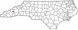
Canton is the second largest town in Haywood County, North Carolina, United States. It is located about 17 miles (27 km) west of Asheville and is part of that city's metropolitan area. The town is named after the city of Canton, Ohio. The population was 4,227 at the 2010 census.[5]
Canton, North Carolina | |
|---|---|
 Seal | |
| Motto(s): "Where the mountains kiss the sky" | |
 Location of Canton, North Carolina | |
| Coordinates: 35°32′5″N 82°50′15″W | |
| Country | United States |
| State | North Carolina |
| County | Haywood |
| Area | |
| • Total | 3.72 sq mi (9.64 km2) |
| • Land | 3.72 sq mi (9.64 km2) |
| • Water | 0.00 sq mi (0.00 km2) |
| Elevation | 2,615 ft (797 m) |
| Population (2010) | |
| • Total | 4,227 |
| • Estimate (2019)[2] | 4,347 |
| • Density | 1,168.23/sq mi (451.10/km2) |
| Time zone | UTC-5 (Eastern (EST)) |
| • Summer (DST) | UTC-4 (EDT) |
| ZIP code | 28716 |
| Area code(s) | 828 |
| FIPS code | 37-10240[3] |
| GNIS feature ID | 1019518[4] |
| Website | www |
History
This area was long settled by succeeding indigenous cultures. What is known as the archeological Garden Creek site, located along Pigeon Creek about 7 miles west of Canton, was inhabited since 8000 BCE. The Southeast Appalachian Mississippian culture and later historic Cherokee people were the most recent Native Americans to occupy this area. This was part of the Cherokee homelands.
European Americans did not begin to settle here until the late 1780s, following the American Revolutionary War and United States independence. By 1790 Jonathan McPeters was farming the banks of the Pigeon River at the site where Canton developed.[6] Around 1815 the first church was built in what was to become Canton; it was called the Locust Old Field Baptist Church. Old Field referred to an area cultivated by the Cherokee people, as this was part of their traditional homelands.[7]
Canton was founded in 1889 as "Buford". Later that same year the name was changed to "Vinson". The name was changed to "Pigeon Ford" in 1891, and to "Canton" in 1893. The town was named for Canton, Ohio, the source of the steel for the bridge that was built across the Pigeon River.
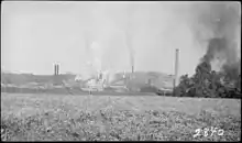
Canton's river location enabled the development of industry that used water power. It was the site of a Champion International Paper factory, which became the largest employer in the city. When Champion owners decided to close the plant in 1997 because of environmental issues, the employees purchased the plant and formed Blue Ridge Paper Company.[8] Under an ESOP, the employees owned a 45% stake in the new company. It has since been sold. The plant is now owned by Evergreen Packaging. The Blue Ridge Southern Railroad serves the plant and has a small railyard next to it.
The Canton Main Street Historic District and Colonial Theater are listed on the National Register of Historic Places.[9]
Geography
Canton is in east-central Haywood County, on both sides of the Pigeon River. U.S. Routes 19 and 23 pass through the center of town as Park Street and Main Street. The highways lead east 17 miles (27 km) to Asheville and west 7 miles (11 km) to Lake Junaluska. Interstate 40 passes through the northernmost part of Canton, with access from Exits 31 and 33. I-40 leads east to Asheville and northwest through the Pigeon River Gorge into Tennessee.
According to the U.S. Census Bureau, the town of Canton has a total area of 3.8 square miles (9.8 km2), all of it recorded as land.[5]
Demographics
| Historical population | |||
|---|---|---|---|
| Census | Pop. | %± | |
| 1900 | 230 | — | |
| 1910 | 1,393 | 505.7% | |
| 1920 | 2,584 | 85.5% | |
| 1930 | 5,117 | 98.0% | |
| 1940 | 5,037 | −1.6% | |
| 1950 | 4,906 | −2.6% | |
| 1960 | 5,068 | 3.3% | |
| 1970 | 5,158 | 1.8% | |
| 1980 | 4,631 | −10.2% | |
| 1990 | 3,790 | −18.2% | |
| 2000 | 4,029 | 6.3% | |
| 2010 | 4,227 | 4.9% | |
| 2019 (est.) | 4,347 | [2] | 2.8% |
| U.S. Decennial Census[10] | |||
As of the census[3] of 2000, there were 4,029 people, 1,819 households, and 1,118 families residing in the town. The population density was 1,054.6 people per square mile (407.2/km2). There were 2,003 housing units at an average density of 524.3 per square mile (202.5/km2). The racial makeup of the town was 96.13% White, 1.59% African American, 0.57% Native American, 0.10% Asian, 0.94% from other races, and 0.67% from two or more races. Hispanic or Latino of any race were 2.41% of the population.
There were 1,819 households, out of which 22.7% had children under the age of 18 living with them, 47.7% were married couples living together, 10.5% had a female householder with no husband present, and 38.5% were non-families. 35.4% of all households were made up of individuals, and 20.3% had someone living alone who was 65 years of age or older. The average household size was 2.17 and the average family size was 2.78.
In the town, the population was spread out, with 19.6% under the age of 18, 6.9% from 18 to 24, 26.0% from 25 to 44, 24.1% from 45 to 64, and 23.5% who were 65 years of age or older. The median age was 43 years. For every 100 females, there were 85.9 males. For every 100 females age 18 and over, there were 81.7 males.
The median income for a household in the town was $28,775, and the median income for a family was $38,191. Males had a median income of $28,792 versus $22,143 for females. The per capita income for the town was $17,995. About 9.5% of families and 13.3% of the population were below the poverty line, including 24.6% of those under age 18 and 5.9% of those age 65 or over.
Schools
- Pisgah High School
- Canton Middle School
- North Canton Elementary
- Bethel Middle School
- Bethel Elementary School
- Meadowbrook Elementary
- Bethel Christian Academy
Scouting
- Camp Daniel Boone, Boy Scouts of America
References
- "2019 U.S. Gazetteer Files". United States Census Bureau. Retrieved July 27, 2020.
- "Population and Housing Unit Estimates". United States Census Bureau. May 24, 2020. Retrieved May 27, 2020.
- "U.S. Census website". United States Census Bureau. Retrieved 2008-01-31.
- "US Board on Geographic Names". United States Geological Survey. 2007-10-25. Retrieved 2008-01-31.
- "Geographic Identifiers: 2010 Census Summary File 1 (G001): Canton town, North Carolina". American Factfinder. U.S. Census Bureau. Archived from the original on February 13, 2020. Retrieved December 13, 2017.
- Blackmun, Ora (1977). Western North Carolina: Its Mountains and Its People to 1880. Boone, North Carolina: Appalachian Consortium Press. p. 161. OCLC 2646301.
- (Blackmun 1977, p. 181)
- "Olmsted: the successful venture". dept.kent.edu/oeoc/publicationsresearch/Sum1999/OlmstedSum1999.html. Missing or empty
|url=(help) - "National Register Information System". National Register of Historic Places. National Park Service. July 9, 2010.
- "Census of Population and Housing". Census.gov. Retrieved June 4, 2015.
External links
| Wikimedia Commons has media related to Canton, North Carolina. |
Municipalities and communities of Haywood County, North Carolina, United States | ||
|---|---|---|
| Towns | 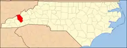 | |
| CDPs | ||
| Unincorporated communities | ||
| Indian reservation | ||
| Footnotes | ‡This populated place also has portions in an adjacent county or counties | |
| ||
| Authority control |
|---|