Castle Acre
Castle Acre is a village and civil parish in the English county of Norfolk. The village is situated on the River Nar some 4 miles (6.4 km) north of the town of Swaffham. It is 15 miles (24 km) east of the town of King's Lynn, 33 miles (53 km) west of the city of Norwich, and 103 miles (166 km) from London.[1][2]
| Castle Acre | |
|---|---|
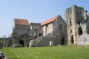
 The Priory, Castle Acre | |
 Castle Acre Location within Norfolk | |
| Area | 13.18 km2 (5.09 sq mi) |
| Population | 848 (2011) |
| • Density | 64/km2 (170/sq mi) |
| OS grid reference | TF816151 |
| • London | 103 miles (166 km) |
| District | |
| Shire county | |
| Region | |
| Country | England |
| Sovereign state | United Kingdom |
| Post town | KING'S LYNN |
| Postcode district | PE32 |
| Police | Norfolk |
| Fire | Norfolk |
| Ambulance | East of England |

The village is best known today for the twin ruins of Castle Acre Castle and Castle Acre Priory, which lie immediately to the east and west of the village respectively. Both were founded soon after the Norman Conquest by William de Warenne, the first Earl of Surrey. At its heyday, Castle Acre played an important role in the affairs of the State, with many visits from royalty. Castle Acre itself was once a fortified town and still possesses one of its gates, the Bailey Gate. When first established, Castle Acre was one of the finest examples of Norman town planning in the country, and much of this can still be seen.[3]
The civil parish has an area of 13.18 km2 (5.09 sq mi) and in the 2001 census had a population of 799 in 370 households, the population increasing to 848 at the 2011 Census.[4] The parish shares boundaries with the adjacent parishes of Rougham, Great Massingham, West Acre, South Acre, Newton by Castle Acre and Lexham. The parish falls within the district of King's Lynn and West Norfolk. Local government responsibilities are shared between the parish, district and county councils.[5][6] Castle Acre forms part of the North West Norfolk constituency in the House of Commons. Norfolk County Council is responsible for roads, some schools, and social services, and the county councillor for the Gayton division, including Castle Acre, is Graham Robin Middleton (Conservative).
The village lies some 0.5 miles (0.80 km) west of the A1065 Mildenhall to Fakenham road, but is clearly visible from the road. The hamlet of Fiddler's Green lies to the northeast of the village.[7]
References
- Ordnance Survey (1999). OS Explorer Map 236 - King's Lynn, Downham Market & Swaffham. ISBN 0-319-21867-8.
- Distances are "by road" and derived using "Google Maps". Retrieved on 2009-01-14.
- Castles Abbeys and Medieval Buildings. Castle Acre Castle Priory. Retrieved 9 February 2006.
- "Civil Parish population 2011". Retrieved 26 August 2015.
- Office for National Statistics & Norfolk County Council (2001). Census population and household counts for unparished urban areas and all parishes. Retrieved 2 December 2005.
- "Election Maps". Ordnance Survey. Archived from the original on 7 March 2008. Retrieved 14 January 2009.
- Kagachi, Chihiro (1988). Atlas of Norfolk.
External links
| Wikimedia Commons has media related to Castle Acre. |
- Information from Genuki Norfolk on Castle Acre.
- English Heritage Castle Acre castle and bailey gate