Cathcart, Eastern Cape
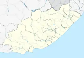
Cathcart is a town in the Eastern Cape province of South Africa, named after Sir George Cathcart, governor of the Colony of the Cape of Good Hope 1852–1853. The town is the biltong capital of South Africa. The town is situated on the N6, 48 kilometres (30 mi) north of Stutterheim en route to Komani.
Cathcart | |
|---|---|
 Main street in Cathcart | |
 Cathcart  Cathcart  Cathcart | |
| Coordinates: 32°18′S 27°08′E | |
| Country | South Africa |
| Province | Eastern Cape |
| District | Amathole |
| Municipality | Amahlathi |
| Established | 1858[1] |
| Area | |
| • Total | 30.1 km2 (11.6 sq mi) |
| Population (2011)[2] | |
| • Total | 7,360 |
| • Density | 240/km2 (630/sq mi) |
| Racial makeup (2011) | |
| • Black African | 93.4% |
| • Coloured | 2.0% |
| • Indian/Asian | 0.1% |
| • White | 4.3% |
| • Other | 0.2% |
| First languages (2011) | |
| • IsiXhosa | 90.6% |
| • English | 4.5% |
| • Afrikaans | 3.1% |
| • Other | 1.8% |
| Time zone | UTC+2 (SAST) |
| Postal code (street) | 5310 |
| PO box | 5310 |
| Area code | 045 |
Establishment
Originally a small military post, established during the Eighth Frontier War, it was established as a village in 1858 when German colonists arrived in the region. Work on its railway connection to East London on the coast was begun by the Cape government of John Molteno in 1876 and the line was officially opened on 3 November 1879.[3]
Religion
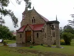
St. Alban's Anglican Church,[lower-alpha 1] built in 1886 is a well known landmark in Cathcart and has an unusual and distinctive Western façade.[4]
Education
There are a number of high schools and primary schools in Cathcart. Cathcart High School is located North of the town near the N6 route to Queenstown.[lower-alpha 2]
Notable people
References
- St. Alban's Anglican Church is located at 32°17′51″S 27°08′32″E
- Cathcart High School is located at 32°17′39″S 27°08′32″E
- "Chronological order of town establishment in South Africa based on Floyd (1960:20–26)" (PDF). pp. xlv–lii.
- Sum of the Subplaces Katikati SP, Daliwe SP, Carthcart SP and Rocklands from Census 2011.
- Burman 1984, p. 83.
- Menache & David 2015, p. 16.
- Burman, Jose (1984). Early railways at the Cape. Human & Rousseau.CS1 maint: ref=harv (link)
- Menache, Philippe; David, Darryl Earl (2015). Church Tourism in South Africa: A Travel Odyssey : Also Featuring, On Tour with Wynand Louw. Menache and David (Self published). ISBN 978-0-620-67799-8.CS1 maint: ref=harv (link)
External links
![]() Media related to Cathcart at Wikimedia Commons
Media related to Cathcart at Wikimedia Commons
Municipalities and communities of Amathole District Municipality, Eastern Cape | ||
|---|---|---|
District seat: East London | ||
| Amahlathi | .svg.png.webp) Amathole District within South Africa | |
| Great Kei | ||
| Mbhashe | ||
| Mnquma | ||
| Ngqushwa | ||
| Raymond Mhlaba | ||