Central dense overcast
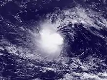
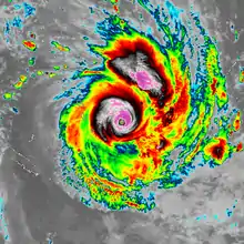
The central dense overcast, or CDO, of a tropical cyclone or strong subtropical cyclone is the large central area of thunderstorms surrounding its circulation center, caused by the formation of its eyewall. It can be round, angular, oval, or irregular in shape. This feature shows up in tropical cyclones of tropical storm or hurricane strength. How far the center is embedded within the CDO, and the temperature difference between the cloud tops within the CDO and the cyclone's eye, can help determine a tropical cyclone's intensity. Locating the center within the CDO can be a problem for strong tropical storms and with systems of minimal hurricane strength as its location can be obscured by the CDO's high cloud canopy. This center location problem can be resolved through the use of microwave satellite imagery.

After a cyclone strengthens to around hurricane intensity, an eye appears at the center of the CDO, defining its center of low pressure and its cyclonic wind field. Tropical cyclones with changing intensity have more lightning within their CDO than steady state storms. Tracking cloud features within the CDO using frequently updated satellite imagery can also be used to determine a cyclone's intensity. The highest maximum sustained winds within a tropical cyclone, as well as its heaviest rainfall, are usually located under the coldest cloud tops in the CDO.
Characteristics

It is a large region of thunderstorms surrounding the center of stronger tropical and subtropical cyclones which shows up brightly (with cold cloud tops) on satellite imagery.[1][2][3] The CDO forms due to the development of an eyewall within a tropical cyclone.[4] Its shape can be round, oval, angular, or irregular.[5] Its development can be preceded by a narrow, dense, C-shaped convective band. Early in its development, the CDO is often angular or oval in shape, which rounds out, increases in size, and appears more smooth as a tropical cyclone intensifies.[6] Rounder CDO shapes occur in environments with low levels of vertical wind shear.[2]
The strongest winds within tropical cyclones tend to be located under the deepest convection within the CDO, which is seen on satellite imagery as the coldest cloud tops.[7] The radius of maximum wind is usually collocated with the coldest cloud tops within the CDO,[7] which is also the area where a tropical cyclone's rainfall reaches its maximum intensity.[8] For mature tropical cyclones that are steady state, the CDO contains nearly no lightning activity, though lightning is more common within weaker tropical cyclones and for systems fluctuating in intensity.[9]
Eye
The eye is a region of mostly calm weather at the center of the CDO of strong tropical cyclones. The eye of a storm is a roughly circular area, typically 30–65 kilometres (19–40 mi) in diameter. It is surrounded by the eyewall, a ring of towering thunderstorms surrounding its center of circulation. The cyclone's lowest barometric pressure occurs in the eye, and can be as much as 15% lower than the atmospheric pressure outside the storm.[10] In weaker tropical cyclones, the eye is less well-defined or nonexistent, and can be covered by high cloudiness caused by cirrus cloud outflow from the surrounding central dense overcast.[10]
Use as a tropical cyclone strength indicator

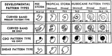
Within the Dvorak satellite strength estimate for tropical cyclones, there are several visual patterns that a cyclone may take on which define the upper and lower bounds on its intensity. The central dense overcast (CDO) pattern is one of those patterns. The central dense overcast utilizes the size of the CDO. The CDO pattern intensities start at T2.5, equivalent to minimal tropical storm intensity, 40 mph (64 km/h). The shape of the central dense overcast is also considered. The farther the center is tucked into the CDO, the stronger it is deemed.[5] Banding features can be utilized to objectively determine the tropical cyclone's center, using a ten degree logarithmic spiral.[11] Using the 85–92 GHz channels of polar-orbiting microwave satellite imagery can definitively locate the center within the CDO.[12]
Tropical cyclones with maximum sustained winds between 65 mph (105 km/h) and 100 mph (160 km/h) can have their center of circulations obscured by cloudiness within visible and infrared satellite imagery, which makes diagnosis of their intensity a challenge.[13] Winds within tropical cyclones can also be estimated by tracking features within the CDO using rapid scan geostationary satellite imagery, whose pictures are taken minutes apart rather than every half-hour.[14]
References
- American Meteorological Society (June 2000). "AMS Glossary: C". Glossary of Meteorology. Allen Press. Retrieved 2006-12-14.
- Landsea, Chris (2005-10-19). "What is a "CDO"?". Atlantic Oceanographic and Meteorological Laboratory. Retrieved 2006-06-14.
- Hebert, Paul H.; Kenneth O. Poteat (July 1975). "A Satellite Classification Technique For Subtropical Cyclones". National Weather Service Southern Region Headquarters: 9. Cite journal requires
|journal=(help) - Elsner, James B.; A. Birol Kara (1999-06-10). Hurricanes of the North Atlantic: Climate and Society. Oxford University Press. p. 3. ISBN 978-0195125085.
- Dvorak, Vernon F. (February 1973). "A Technique For the Analysis and Forecasting of Tropical Cyclone Intensities From Satellite Pictures". National Oceanic and Atmospheric Administration: 5–8. Cite journal requires
|journal=(help) - Dvorak, Vernon F. (May 1975). "Tropical Cyclone Intensity Analysis and Forecasting From Satellite Imagery". Monthly Weather Review. 103 (5): 422. Bibcode:1975MWRv..103..420D. doi:10.1175/1520-0493(1975)103<0420:tciaaf>2.0.co;2.
- Hsu, S. A.; Adele Babin (February 2005). "Estimating the Radius of Maximum Winds Via Satellite During Hurricane Lili (2002) Over the Gulf of Mexico" (PDF). Archived from the original (PDF) on 2012-02-06. Retrieved 2007-03-18.
- Muramatsu, Teruo (1985). "The Study on the Changes of the Three-dimensional Structure and the Movement Speed of the Typhoon through its Life Time" (PDF). Tech. Rep. Meteorol. Res. Inst. Number 14: 3. Retrieved 2009-11-20.
- Demetriades, Nicholas W.S.; Martin J. Murphy & Ronald L. Holle (2005-06-22). "Long Range Lightning Nowcasting Applications For Meteorology" (PDF). Vaisala. Retrieved 2012-08-12.
- Landsea, Chris & Sim Aberson (2004-08-13). "What is the "eye"?". Atlantic Oceanographic and Meteorological Laboratory. Retrieved 2006-06-14.
- Velden, Christopher; Bruce Harper; Frank Wells; John L. Beven II; Ray Zehr; Timothy Olander; Max Mayfield; Charles “Chip” Guard; Mark Lander; Roger Edson; Lixion Avila; Andrew Burton; Mike Turk; Akihiro Kikuchi; Adam Christian; Philippe Caroff & Paul McCrone (September 2006). "The Dvorak Tropical Cyclone Intensity Estimation Technique: A Satellite-Based Method That Has Endured For Over 30 Years" (PDF). Bulletin of the American Meteorological Society. 87 (9): 1195–1214. Bibcode:2006BAMS...87.1195V. CiteSeerX 10.1.1.669.3855. doi:10.1175/bams-87-9-1195. Retrieved 2012-09-26.
- Wimmers, Anthony J.; Christopher S. Velden (September 2012). "Objectively Determining the Rotational Center of Tropical Cyclones in Passive Microwave Satellite Imagery". Journal of Applied Meteorology and Climatology. 49 (9): 2013–2034. Bibcode:2010JApMC..49.2013W. doi:10.1175/2010jamc2490.1.
- Wimmers, Anthony; Chistopher Velden (2012). "Advances in Objective Tropical Cyclone Center Fixing Using Multispectral Satellite Imagery". American Meteorological Society. Retrieved 2012-08-12.
- Rogers, Edward; R. Cecil Gentry; William Shenk & Vincent Oliver (May 1979). "The Benefits of Using Short-Interval Satellite Images To Derive Winds For Tropical Cyclones". Monthly Weather Review. 107 (5): 575. Bibcode:1979MWRv..107..575R. doi:10.1175/1520-0493(1979)107<0575:tbousi>2.0.co;2.
