Chassezac
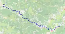
The Chassezac (French: le Chassezac) is an 84.6 km (52.6 mi) long river in the Lozère, Gard and Ardèche departments in southern France. It is a right tributary of the Ardèche.[1] Its source is in the commune of Saint-Frézal-d'Albuges, 2.8 km (1.7 mi) northeast of Les Chazeaux, the main hamlet in the commune. It flows generally southeast and flows into the Ardèche at Saint-Alban-Auriolles, 1.8 km (1.1 mi) east of the village itself.
| Chassezac | |
|---|---|
 the Chassezac | |
 | |
| Location | |
| Country | France |
| Physical characteristics | |
| Source | |
| • location | in Saint-Frézal-d'Albuges |
| • coordinates | 44°35′30″N 03°46′47″E |
| • elevation | 1,350 m (4,430 ft) |
| Mouth | |
• location | Ardèche |
• coordinates | 44°25′39″N 04°19′12″E |
• elevation | 95 m (312 ft) |
| Length | 84.6 km (52.6 mi) |
| Basin size | 560 km2 (220 sq mi) |
| Discharge | |
| • average | 15.3 m3/s (540 cu ft/s) |
| Basin features | |
| Progression | Ardèche→ Rhône→ Mediterranean Sea |
Departments and communes it runs through
The following list is ordered from source to mouth :
- Lozère: Saint-Frézal-d'Albuges, Belvezet, Chasseradès, La Bastide-Puylaurent, Prévenchères, Pied-de-Borne
- Ardèche: Sainte-Marguerite-Lafigère,
- Gard: Malons-et-Elze
- Ardèche: Malarce-sur-la-Thines, Gravières, Les Salelles, Chambonas, Les Assions, Les Vans, Berrias-et-Casteljau, Chandolas, Beaulieu, Grospierres, Sampzon, Saint-Alban-Auriolles,
References
This article is issued from Wikipedia. The text is licensed under Creative Commons - Attribution - Sharealike. Additional terms may apply for the media files.
