Sainte-Marguerite-Lafigère
Sainte-Marguerite-Lafigère is a commune in the Ardèche department in southern France.
Sainte-Marguerite-Lafigère | |
|---|---|
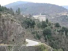 A general view of Sainte-Marguerite-Lafigère | |
Location of Sainte-Marguerite-Lafigère 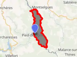
| |
 Sainte-Marguerite-Lafigère  Sainte-Marguerite-Lafigère | |
| Coordinates: 44°28′43″N 3°59′20″E | |
| Country | France |
| Region | Auvergne-Rhône-Alpes |
| Department | Ardèche |
| Arrondissement | Largentière |
| Canton | Les Cévennes ardéchoises |
| Government | |
| • Mayor (2008–2014) | Elie Louche |
| Area 1 | 10.07 km2 (3.89 sq mi) |
| Population (2017-01-01)[1] | 107 |
| • Density | 11/km2 (28/sq mi) |
| Time zone | UTC+01:00 (CET) |
| • Summer (DST) | UTC+02:00 (CEST) |
| INSEE/Postal code | 07266 /07140 |
| Elevation | 255–1,000 m (837–3,281 ft) (avg. 450 m or 1,480 ft) |
| 1 French Land Register data, which excludes lakes, ponds, glaciers > 1 km2 (0.386 sq mi or 247 acres) and river estuaries. | |
Geography
The commune is traversed by the river Chassezac.
Population
|
|
See also
References
- "Populations légales 2017". INSEE. Retrieved 6 January 2020.
| Wikimedia Commons has media related to Sainte-Marguerite-Lafigère. |
This article is issued from Wikipedia. The text is licensed under Creative Commons - Attribution - Sharealike. Additional terms may apply for the media files.