Checkerboard Hill
Checkerboard Hill (Chinese: 格仔山) is a small hill in the northern part of the Kowloon peninsula in Hong Kong. Standing at 98 metres (322 ft) tall, Checkerboard Hill is located next to Kowloon Tsai Park and is not far from Lion Rock Country Park.
| Checkerboard Hill, Hong Kong | |
|---|---|
| 格仔山 | |
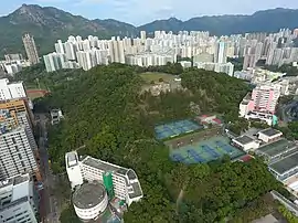 View of Checkerboard Hill. The faded checkerboard is visible. | |
| Highest point | |
| Elevation | 98 m (322 ft) |
| Coordinates | 22°20′09″N 114°11′03″E |
| Geography | |
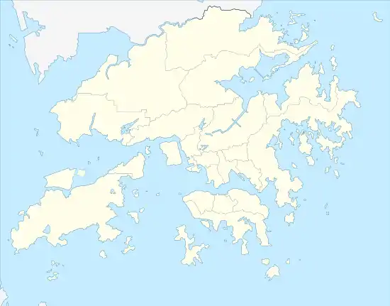 Checkerboard Hill, Hong Kong Location of Checkerboard Hill in Hong Kong | |
| Location | |
Name
The hill's name dates back to the time when airline pilots had to navigate towards this hill in order to land on Runway 13 of the now-closed Kai Tak Airport. Pilots would set their onboard navigation systems to fly the Instrument Guidance System (IGS) path straight towards a large red and white checkerboard on the side of the hill, then once the checkerboard pattern was sighted and identified, they would make a low-altitude right-hand turn to align visually with Runway 13.[1]
Kai Tak Airport was demanding for pilots, and it required special training, since the approach to runway 13 could not be flown entirely by instrument, but required instead to aim towards a fixed obstacle, and then break away visually to land on its right.
Today
The hill still remains along with the checkerboard, which has now faded and is overgrown with new trees. The faded checkerboard can still be seen from Kowloon Tsai Park.
References
- "Restore famous 'checkerboard' as a tribute to old Kai Tak airport". South China Morning Post. 2019-04-16. Retrieved 2020-03-30.
| Wikimedia Commons has media related to Checkerboard Hill. |