Chemerivtsi Raion
Chemerivtsi Raion (Ukrainian: Чемеровецький район, Chemerovets'kyi raion) was one of the 20 administrative raions (a district) of Khmelnytskyi Oblast in western Ukraine. Its administrative center was located in the urban-type settlement of Chemerivtsi. Its population was 51,009 in the 2001 Ukrainian Census.[1] The raion was abolished on 18 July 2020 as part of the administrative reform of Ukraine, which reduced the number of raions of Khmelnytskyi Oblast to three.[2][3] The last estimate of the raion population was 38,770 (2020 est.)[4]
Chemerivtsi Raion
Чемеровецький район | |
|---|---|
 Flag  Coat of arms | |
 | |
| Coordinates: 48°58′35″N 26°22′16″E | |
| Country | |
| Region | Khmelnytskyi Oblast |
| Established | 7 March 1923 |
| Disestablished | 18 July 2020 |
| Admin. center | Chemerivtsi |
| Subdivisions | List
|
| Government | |
| • Governor | Volodymyr Svizhyi[1] (PR) |
| Area | |
| • Total | 930 km2 (360 sq mi) |
| Population (2020) | |
| • Total | |
| Time zone | UTC+02:00 (EET) |
| • Summer (DST) | UTC+03:00 (EEST) |
| Postal index | 31600—31666 |
| Area code | +380 3859 |
| Website | chem-rda.inf.ua |
Geography
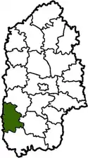
Chemerivtsi Raion was located in the southwestern part of the Khmelnytskyi Oblast,[5] in the modern-day boundaries of the Podolia historical region. Its total area constituted 930 square kilometres (360 sq mi).[1] To its west, the raion bordered upon the neighboring Ternopil Oblast.
History
Chemerivtsi Raion was first established on March 7, 1923 as part of a full-scale administrative reorganization of the Ukrainian Soviet Socialist Republic,[1] from the former territories of Vilkhivtsi and Berezhany volosts (a former administrative division roughly equivalent to that of a modern raion).[5]
Administrative divisions
Chemerivtsi Raion was divided in a way that followed the general administrative scheme in Ukraine. Local government was also organized along a similar scheme nationwide. Consequently, raions were subdivided into councils, which were the prime level of administrative division in the country.
Each of the raion's urban localities administered their own councils, often containing a few other villages within its jurisdiction. However, only a handful of rural localities were organized into councils, which also might contain a few villages within its jurisdiction.
Accordingly, the Chemerivtsi Raion was divided into:[1]
- 2 settlement councils—made up of the urban-type settlements of Chemerivtsi (administrative center) and Zakupne
- 33 village councils
Overall, the raion had a total of 70 populated localities, consisting of two urban-type settlements, and 68 villages.[1]
References
- "Chemerivtsi Raion, Khmelnytskyi Oblast". Regions of Ukraine and their Structure (in Ukrainian). Verkhovna Rada of Ukraine. Archived from the original on 4 March 2016. Retrieved 11 January 2013.
- "Про утворення та ліквідацію районів. Постанова Верховної Ради України № 807-ІХ". Голос України (in Ukrainian). 2020-07-18. Retrieved 2020-10-03.
- "Нові райони: карти + склад" (in Ukrainian). Міністерство розвитку громад та територій України.
- "Чисельність наявного населення України (Actual population of Ukraine)" (PDF) (in Ukrainian). State Statistics Service of Ukraine. Retrieved 30 September 2020.
- "Chemerivtsi Raion - reference". National Environmental Park "Podilski Tovtry" (in Ukrainian). Retrieved 11 January 2013.
External links
| Wikimedia Commons has media related to Chemerivtsi Raion. |
- "Official web-site". Chemerivtsi Raion State Administration (in Ukrainian). Archived from the original on 19 January 2011. Retrieved 12 March 2013.
- "Official site". Chemerivtsi Raion Rada (in Ukrainian). Archived from the original on 19 April 2013. Retrieved 12 March 2013.
Administrative geographic location | |
|---|---|
| Settlements | Coat of arms of Chemerivtsi Raion | |
|---|---|---|
| Villages |
| |
| Raions | |||||
|---|---|---|---|---|---|
| Hromadas | |||||
| Cities |
| ||||
| |||||