Chestermere Lake
Chestermere Lake is a man-made reservoir in Chestermere, Alberta, Canada.
| Chestermere Lake | |
|---|---|
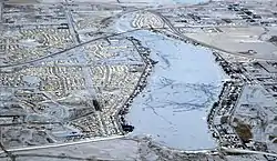 in winter | |
 Chestermere Lake | |
| Location | Chestermere, Alberta |
| Coordinates | 51°02′20″N 113°49′07″W |
| Type | reservoir |
| Basin countries | Canada |
| Max. length | 5 km (3.1 mi) |
| Max. width | 0.7 km (0.43 mi) |
| Surface area | 2.65 km2 (1.02 sq mi) |
| Max. depth | 7 m (23 ft) |
| Surface elevation | 1,028 m (3,373 ft) |
It was built in the 1880s by the Canadian Pacific Railway, for irrigation of the area between Calgary and Strathmore. It is now used mainly for recreation purposes, such as swimming, windsurfing, fishing and skating (in winter). The City of Chestermere surrounds the lake on three sides. The Trans-Canada Highway follows the northeastern shore, while the railway tracks pass by the southern shore.
The lake covers a surface of 2.65 square kilometres (1.02 square miles) and has a maximum depth of 7 metres (23 feet).[1] It drains into two irrigation canals and is filled via a canal from the Bow River along Radisson Heights.
References
- Atlas of Alberta Lakes Archived July 19, 2011, at the Wayback Machine - Chestermere Lake
| Rivers |  Rivers and lakes in Alberta | |
|---|---|---|
| Waterfalls | ||
| Lakes | ||
| Reservoirs | ||
| Glaciers | ||
| Other | ||
This article is issued from Wikipedia. The text is licensed under Creative Commons - Attribution - Sharealike. Additional terms may apply for the media files.