Chiricahua Mountains
The Chiricahua Mountains massif is a large mountain range in southeastern Arizona which is part of the Basin and Range province of the west and southwestern United States and northwest Mexico; the range is part of the Coronado National Forest. The highest point, Chiricahua Peak, rises 9,759 feet (2,975 m) above sea level, approximately 6,000 feet (1,800 m) above the surrounding valleys. The range takes its name from the Chiricahua Apaches native to the region.
| Chiricahua Mountains | |
|---|---|
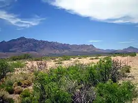 Chiricahua Mountains - northeast flank (from Portal, AZ) | |
| Highest point | |
| Peak | Chiricahua Peak |
| Elevation | 9,759 ft (2,975 m) |
| Coordinates | 31°50′47″N 109°17′28″W |
| Dimensions | |
| Length | 35 mi (56 km) NW, then SW |
| Width | 21 mi (34 km) (arc-shape)-N-S |
| Geography | |
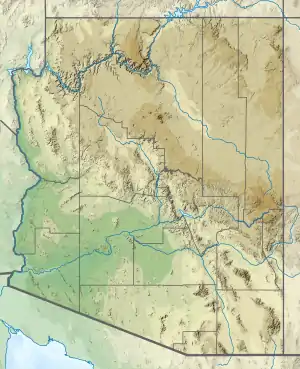 Chiricahua Mountains in Arizona | |
| Country | United States |
| State | Arizona |
| Regions | Madrean Sky Islands, Sonoran Desert and Chihuahuan Desert |
| County | Cochise |
| Communities | Willcox, Douglas, Rodeo and Portal |
| Range coordinates | 31°55′47″N 109°22′56″W |
| Borders on | Dos Cabezas Mountains, San Simon Valley, San Bernardino Valley, Pedregosa Mountains and Sulphur Springs Valley |
The Chiricahua Mountains, and other associated ranges, along with Sulphur Springs Valley on the west and the San Simon Valley on the east, form the eastern half of Cochise County in southeast Arizona. The Pedregosa Mountains are found at the southern end of the Chiricahua Mountains, while the Swisshelm Mountains are located to the southwest. The northwest end of the Chiricahua mountains continue as the Dos Cabezas Mountains beyond Apache Pass and the Fort Bowie National Historic Site. Access to the Chiricahua Mountains and Coronado National Forest is through Willcox from the north, Douglas from the south, and Rodeo from the east.
Most of the range lies within the 87,700-acre (35,500 ha) Chiricahua Wilderness, managed by the Coronado National Forest.[1]
History
The earliest evidence of humans in the vicinity of the Chiricahua Mountains are Clovis archeological sites such as Double Adobe Site in the Whitewater Draw tributary of Rucker Creek north of Douglas. Subsequently, the Cochise culture another pre-ceramic based culture spanning 3000 - 200 BCE was defined from sites around the Chiricahua Mountains, including Cave Creek Canyon.[2] Following the transition to ceramics,[3] artifacts characteristic of both Mogollon culture and its local variants, the Mimbres culture, are found. These relics span the period from 150 BCE - 1450. The influx of other indigenous peoples, such as the Chiricahua Apaches, including the leaders Cochise and Geronimo occupied the area until forced removal in the late 19th century.
The name Chiricahua is believed to originate from the Opata name for the mountains, Chiwi Kawi, meaning "Turkey Mountain".[4][5][6] The Chiricahuas were once known for an abundance of wild turkeys.
The first recorded mining claim in the Chiricahua Mountains was the Hidden Treasure claim filed in 1881, and mining has continued intermittently to the present with the greatest periods of activity occurring in the 1920s and 1950s.[7]
More recently, the Chiricahuas have fallen into use by people smugglers and drug cartels, who position lookouts on their peaks to warn of Border Patrol activities.[8][9]
Geology overview
The Chiricahua Mountains are an uplifted structural block of the Basin and Range. The mountains contain Precambrian basement rocks, Paleozoic and Cretaceous sedimentary rocks around a caldera complex formed by volcanic eruptions and intrusions 35 - 25 million years ago.[10][11] The last major eruption, 27 million years ago, created the Turkey Creek Caldera and laid down 2,000 feet (610 m) of volcanic ash which fused into welded rhyolite tuff.[12] Subsequent erosion has created mountain ridges covered in stone spires and stone columns, hoodoos, that rise up out of the forest. These natural features, preserved in the Chiricahua National Monument, are composed of Rhyolite Canyon Tuff.
A one to two mile wide band of sedimentary rock running southeast to northwest from south of Portal through Paradise and up to the Dos Cabezas Mountains is the source of mineralized deposits.[7] The largest of the mines developed in the California district of the Chiricahua Mountains was the Hilltop mine which consisted of 3 interconnected levels totaling 6,098 metres (20,007 ft).[13]
Flora and fauna
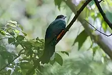
The Chiricahua Mountains are a bio-diverse area which is composed of numerous sky islands.[14] Five of the 9 life zones[15] are found in the Chiricahua Mountains. Three hundred and seventy-five avian species have been recorded from the Chiricahua Mountains; some are largely Mexican species for which southern Arizona is the northern limits of their ranges.[16] Other animals of note include ocelots, jaguars, mountain lions, nine-banded armadillo, black bears, and white-tailed deer.
With the base of the Chiricahuas at about 3,600 feet (1,100 m),[17] the range covers about 6,000 feet (1,800 m) in elevation. Grasslands and desert cover the base of the range, with ponderosa pine and Douglas fir at the highest elevations. Cave Creek Canyon on the east side is home to the American Museum of Natural History Southwest Research Station and the small towns of Portal and Paradise.[18]
Species associated with the range
|
|
Gallery
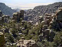
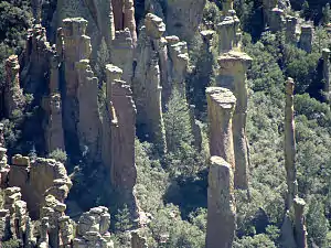 Hoodoos, Chiricahua National Monument
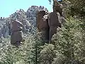 Trees and hoodoos, Chiricahua National Monument
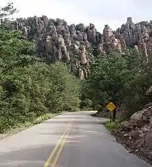 Road to Chiricahua National Monument
 Sunglow Ranch
 Cave Creek Canyon
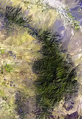 Chiricahua Mountain Range (massif), and its sub-Ranges, with the bordering valleys.
See also
References
- Chiricahua Wilderness Coronado National Forest
- "Arizona Memory Project : Compound Object Viewer". azmemory.lib.az.us. Archived from the original on September 8, 2010. Retrieved September 5, 2010.
- "Arizona Memory Project : Compound Object Viewer". azmemory.lib.az.us. Archived from the original on September 8, 2010. Retrieved September 5, 2010.
- https://www.nps.gov/nr/feature/landscape/2012/Chiricahua.htm
- A Portal to Paradise by Alden C Hayes, pg 337
- DESCRIPCION GEOGRAFICA, NATURAL Y CURIOSA DE LA PROVINCIA DE SONORA, by Juan Nentvig, 1764
- Brown, S. D. (1993), Mineral Appraisal of the Coronado National Forest Part 2, Chiricahua-Pedregosa Mountains Unit, Cochise County, Arizona. United States Department of the Interior, Bureau of Mines, 210 pp. (PDF)
- Nathan Thornburgh (14 June 2011). "Border Crackdowns and the Battle for Arizona". Time Magazine.
- Leo W. Banks (30 June 2011). "Arizona Burning". Tucson Weekly. Archived from the original on 3 July 2011.
- du Bray, Edward A. and John S. Pallister, Recrystallization and anatexis along the plutonic-volcanic contact of the Turkey Creek caldera, Arizona, Geological Society of America Bulletin, 1999, v. 111, no. 1, pp. 143-153
- Pallister, J. S.; Dubray, E. A.; Hall, D. B. (1997), Guide to the volcanic geology of Chiricahua National Monument and vicinity, Cochise County, Arizona, retrieved 2010-09-03
- "CVO Website - Arizona Volcanoes and Volcanics". vulcan.wr.usgs.gov. Retrieved September 3, 2010.
- "Hilltop Mine (Hand Mine; Kasper tunnel; Gray Mine; Dunn shaft; Blacksmith shaft; Rhem adit), Rustler Park, California District, Chiricahua Mts, Cochise Co., Arizona, USA". mindat.org. Retrieved September 5, 2010.
- Scroch, Matt. "Sky Islands of North America: A globally unique and threatened inland archipelago". Terrain.
- "Natural Vegetation of". southwest.library.arizona.edu. Retrieved September 3, 2010.
- "Audubon: Birds & Science [-109.28, 31.9057] - Chiricahua Mountains, Coronado National Forest". iba.audubon.org. Archived from the original on July 26, 2012. Retrieved September 3, 2010.
- Chiricahua Mountains Study Area Archived 2003-04-03 at Archive.today
- Southwest Research Station
- Winter photos, (fireflyforest.net)
External links
| Wikimedia Commons has media related to Chiricahua Mountains. |
- The Nature Explorers Chiricahua Expedition A 2-hour 49 minute ecosystem video.
- "Chiricahua National Monument". National Park Service.
- "Chiricahua Peak, Arizona". Peakbagger.com.
- Chiricahua Peak Summit, trails, mountainzone.com, (coord)
- Chiricahua Mountains Study Area
- Map of Chiricahua and Dos Cabezas Mountains
- Chiricahua - Peloncillo Historical Society
- The short film Chiricahuas: Mountain Islands in the Desert (1998) is available for free download at the Internet Archive