Grand Wash Cliffs
The Grand Wash Cliffs[1] extend south-southeast from the Grand Canyon-Parashant National Monument in northwest Arizona west of the Shivwits Plateau south through the Grand Cliffs Wilderness and into the Lake Mead Recreation Area. The Grand Wash Cliffs cross the Grand Canyon where the Colorado River enters Lake Mead. To the south of the Grand Canyon the Grand Wash Cliffs continue past the east side of Grapevine Mesa and then southeast above and east of the Hualapai Valley forming the southwest margin of the Music Mountains.[2]
| Grand Wash Cliffs | |
|---|---|
 Grand Wash Cliffs at Meadview, Arizona (view due-east) | |
| Location | Mohave County, Arizona, Arizona, United States |
| Coordinates | 35.983°N 113.967°W |
| Length | 115 ft (35 m) |
| Width | 5 ft (1.5 m) |
| Formed by | Colorado River |

Foothills of Grand Wash Cliffs, (city-or-landform locations)
List of landforms/communities along Grand Wash Cliffs
(form north-to-south)
- Grand Wash Cliffs Wilderness (~north terminus) (Loc. dot 1)
- Squaw Canyon
- Pigeon Canyon
- Pearce Canyon
- Pearce Ferry, Lake Mead (at Colorado River)
- Meadview, Arizona (Grapevine Mesa, west, at foothills) (Loc. dot 2)
- Garnet Mountain (Loc. dot 3)
- Music Mountains (part of Hualapai Plateau elevations, east)
- Crozier, Arizona
- Valentine, Arizona (at south terminus) (Loc. dot 4)
- Peacock Mountains
- Cane Springs, Arizona (using Upper Burro Creek Wilderness coord.) (Loc. dot 5)
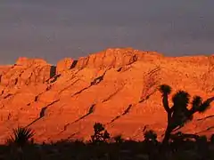 Sunset at Meadview with Joshua trees
 Cliffs, and foothills with Joshua Trees
_January_2007_-_panoramio.jpg.webp) Grand Wash Cliffs, from Pierce Ferry Road
Grand Wash Cliffs, from Pierce Ferry Road
See also
| Wikimedia Commons has media related to Grand Wash Cliffs. |
References
- U.S. Geological Survey Geographic Names Information System: Grand Wash Cliffs
- Arizona Atlas & Gazetteer, DeLorme, Fourth Ed. 2001 pp. 21 and 29 ISBN 0-89933-325-7
External links
- Grand Wash Cliffs Wilderness, AZ at topoquest.com
- Coordinates for Upper Burro Creek Wilderness, for (Cane Springs, Arizona)
Grand Wash Cliffs Wilderness
Geology/Geography
- Geologic Map of the Peacock Mountains and Southern Grand Wash Cliffs, map Citation
- Grand Wash Basin (north Grand Wash Cliffs), maps & description, for water resources, etc.
- Geology strata (photo & graphic) of Grand Wash Cliffs, at Geologic History of the Lake Mead National Recreation Area, at 3dpark.wr.usgs.gov
This article is issued from Wikipedia. The text is licensed under Creative Commons - Attribution - Sharealike. Additional terms may apply for the media files.