Sugarloaf Mountain (Arizona)
Sugarloaf Mountain, of Arizona is the tallest peak in the arid, low elevation Hummingbird Springs Wilderness of northwest Maricopa County, and about 65 miles (105 km) west of Phoenix. It rises in the Tonopah Desert about 10 miles (16 km) northwest of the Belmont Mountains. Hummingbird Springs Wilderness is just north of the Big Horn Mountains Wilderness. The two are separated only by a jeep trail that leads to Hummingbird Springs.[3]
| Sugarloaf Mountain | |
|---|---|
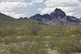 Sugarloaf Mountain in the Hummingbird Springs Wilderness | |
| Highest point | |
| Elevation | 3,420 ft (1,042 m) NGVD 29[1] |
| Prominence | 1,188 ft (362 m) [1] |
| Coordinates | 33°40′41″N 113°03′06″W [2] |
| Geography | |
 Sugarloaf Mountain | |
| Location | Maricopa County, Arizona, U.S. |
| Topo map | USGS Hummingbird Spring |
The areas washes drain the into southwest-flowing Tiger Wash at the southeast of the Harquahala Mountains. Tiger Wash is a tributary wash in the central-upper regions of the southeast flowing Centennial Wash, a tributary to the Gila River.
References
- "Sugarloaf Mountain, Arizona". Peakbagger.com. Retrieved 2014-02-02.
- "Sugarloaf Mountain". Geographic Names Information System. United States Geological Survey.
- "Hummingbird Springs Wilderness". Wilderness.net. Retrieved 2014-02-01.
External links
- "Arizona Wilderness Areas - Public Lands - Recreation Sites". Arizona Outback Online.
This article is issued from Wikipedia. The text is licensed under Creative Commons - Attribution - Sharealike. Additional terms may apply for the media files.