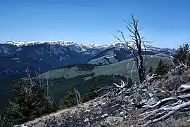
Chopaka Mountain
Chopaka Mountain, also known as Mount Chopaka, is a summit in the leeward flank of the North Cascades. Its summit area is a Natural Area Preserve comprising 2,764 acres (1,119 ha), and features a mountain goat population and various rare plants. The last surviving native herd of bighorn sheep in Washington was located on Chopaka Mountain until hunted out in the 1920s.[3]
| Chopaka Mountain | |
|---|---|
 View from top of Chopaka Mountain | |
| Highest point | |
| Elevation | 7,887 ft (2,404 m) NAVD 88[1] |
| Prominence | 1,811 ft (552 m) [2] |
| Coordinates | 48°57′27″N 119°47′05″W [1] |
| Geography | |
| Location | Okanogan County, Washington, United States |
| Parent range | Okanagan Range, North Cascades |
| Topo map | USGS Hurley Peak |
Name origin
According to the British Columbia Geographical Names Information System, in their record on nearby Chopaka, British Columbia, Chopaka was either an Okanagan hunter turned to stone by "coyote", or a maiden transformed into stone.[4] Another meaning is given by regional climbing guide author Fred Beckey who states that Chopaka is an Indian word meaning "high mountain".[5]
See also
References
- "Chopaka". NGS data sheet. U.S. National Geodetic Survey. Retrieved 2011-06-07.
- "Chopaka Mountain, Washington". Peakbagger.com. Retrieved 2011-06-07.
- "Chopaka Mountain NAP". Washington State Department of Natural Resources. Archived from the original on 2011-05-20. Retrieved 2011-06-07.
- 12th Report of the Okanagan Historical Society, 1948, citing A. Walsh and Parham, cited in "Chopaka (locality)". BC Geographical Names. Retrieved 2011-06-07.
- Beckey, Fred W. (2008). Cascade Alpine Guide, Vol. 3, Rainy Pass to Fraser River (3rd ed.). Mountaineers Books. p. 228. ISBN 1-59485-136-0.
External links
- "Chopaka Mountain". Geographic Names Information System. United States Geological Survey. Retrieved 2011-06-07.
This article is issued from Wikipedia. The text is licensed under Creative Commons - Attribution - Sharealike. Additional terms may apply for the media files.