Chornomorske
Chernomorskoye or Chornomorske (Ukrainian: Чорномо́рське; Russian: Черномо́рское; Crimean Tatar: Aqmeçit, Greek: Καλός Λιμήν) is an urban-type settlement and the administrative center of Chornomorske Raion[1] in Crimea, a territory recognized by a majority of countries as part of Ukraine (the Autonomous Republic of Crimea) and incorporated by Russia as the Republic of Crimea. It is located on the northern edge of the Tarkhankut Peninsula. Population: 11,267 (2014 Census);[4] 11,643 (2001 Census).[1]
Chernomorskoye/Chornomorske
Чорноморське/Черноморское/Aqmeçit | |
|---|---|
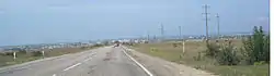 View of Chornomorske | |
 Flag  Coat of arms | |
.svg.png.webp) Chernomorskoye/Chornomorske Location of Chornomorske in Crimea | |
| Coordinates: 45°30′07″N 32°42′09″E | |
| Country | Disputed |
| Republic | Crimea |
| District | Chornomorske Raion |
| Urban-type settlement status | 1957[1] |
| Government | |
| • Head | Serhiy Kryvobokov |
| Area | |
| • Total | 119 km2 (46 sq mi) |
| Elevation | 20 m (70 ft) |
| Population (2014) | |
| • Total | 11,267 |
| • Density | 95/km2 (250/sq mi) |
| Time zone | UTC+4 (MSK) |
| Postal code | |
| Area code | +380 6558 (Ukraine) |
History
The first inhabitants on the shore of the current narrow bay were the Greeks as part of the Greek colonization of the Black Sea. The city of Kalos Limen (Καλός Λιμήν – Lovely Harbor) was founded on this site by Chersonesus in the second half of the 4th century BC. It was one of the important centers of agriculture and trade, among both Greek and Scythian centers. By the middle of the 2nd century BC in the Greco-Scythian war, the town had been captured the Scythians. Although liberated by Pontic intervention by the end of the 2nd century, it again fell under Scythian control by the mid-1st century BC to the early 2nd century AD. Scythian control ended permanently thereafter, possibly owing to Roman intervention.
In Russian the settlement was originally known as Ak-Mechet (Ак-Мечеть), from the Crimean Tatar "Aqmeçit", which literally means a white mosque.[5] A mosque with a tall white minaret used to exist here.[5] After the Crimean Tatars were forcibly deported in 1944, the settlement was given its present name, which alludes to the settlement's coastal location on the Black Sea.[5]
Economy
Chornomorske is a peninsula offshore drilling center and base port.
Climate
| Climate data for Chornomorske | |||||||||||||
|---|---|---|---|---|---|---|---|---|---|---|---|---|---|
| Month | Jan | Feb | Mar | Apr | May | Jun | Jul | Aug | Sep | Oct | Nov | Dec | Year |
| Record high °C (°F) | 16.5 (61.7) |
21.1 (70.0) |
22.5 (72.5) |
28.0 (82.4) |
32.9 (91.2) |
36.5 (97.7) |
39.4 (102.9) |
41.2 (106.2) |
32.9 (91.2) |
28.8 (83.8) |
24.4 (75.9) |
19.4 (66.9) |
41.2 (106.2) |
| Average high °C (°F) | 4.0 (39.2) |
4.2 (39.6) |
7.4 (45.3) |
13.6 (56.5) |
19.3 (66.7) |
24.0 (75.2) |
26.7 (80.1) |
26.6 (79.9) |
21.9 (71.4) |
16.3 (61.3) |
10.3 (50.5) |
5.8 (42.4) |
15.0 (59.0) |
| Daily mean °C (°F) | 1.2 (34.2) |
1.1 (34.0) |
4.0 (39.2) |
9.4 (48.9) |
15.0 (59.0) |
20.0 (68.0) |
22.8 (73.0) |
22.6 (72.7) |
17.9 (64.2) |
12.3 (54.1) |
7.0 (44.6) |
3.1 (37.6) |
11.4 (52.5) |
| Average low °C (°F) | −1.2 (29.8) |
−1.7 (28.9) |
1.1 (34.0) |
5.7 (42.3) |
10.9 (51.6) |
16.1 (61.0) |
18.9 (66.0) |
18.4 (65.1) |
13.7 (56.7) |
8.7 (47.7) |
3.9 (39.0) |
0.5 (32.9) |
7.9 (46.2) |
| Record low °C (°F) | −22.0 (−7.6) |
−22.7 (−8.9) |
−14.7 (5.5) |
−7.1 (19.2) |
−0.5 (31.1) |
5.6 (42.1) |
10.4 (50.7) |
7.2 (45.0) |
0.0 (32.0) |
−5.0 (23.0) |
−13.0 (8.6) |
−17.8 (0.0) |
−22.7 (−8.9) |
| Average precipitation mm (inches) | 24 (0.9) |
25 (1.0) |
24 (0.9) |
25 (1.0) |
25 (1.0) |
28 (1.1) |
30 (1.2) |
26 (1.0) |
45 (1.8) |
35 (1.4) |
41 (1.6) |
31 (1.2) |
359 (14.1) |
| Average rainy days | 9 | 8 | 8 | 8 | 8 | 7 | 5 | 5 | 8 | 8 | 10 | 9 | 93 |
| Average snowy days | 7 | 7 | 3 | 0.3 | 0 | 0 | 0 | 0 | 0 | 0.1 | 2 | 5 | 24 |
| Average relative humidity (%) | 84 | 83 | 81 | 78 | 77 | 77 | 72 | 71 | 73 | 78 | 82 | 83 | 78 |
| Source: Weatherbase[6] | |||||||||||||
References
| Wikimedia Commons has media related to Aqmeçit. |
Notes
- "Chornomorske, Autonomous Republic of Crimea, Chornomorske Raion". Regions of Ukraine and their Structure (in Ukrainian). Verkhovna Rada of Ukraine. Retrieved January 21, 2015.
- "Chornomorske (Crimea, Chornomorske Raion)". weather.in.ua (in Ukrainian). Retrieved January 21, 2015.
- Почта России. Информационно-вычислительный центр ОАСУ РПО. (Russian Post). Поиск объектов почтовой связи Archived September 25, 2009, at the Wayback Machine (Postal Objects Search) (in Russian)
- Russian Federal State Statistics Service (2014). "Таблица 1.3. Численность населения Крымского федерального округа, городских округов, муниципальных районов, городских и сельских поселений" [Table 1.3. Population of Crimean Federal District, Its Urban Okrugs, Municipal Districts, Urban and Rural Settlements]. Федеральное статистическое наблюдение «Перепись населения в Крымском федеральном округе». ("Population Census in Crimean Federal District" Federal Statistical Examination) (in Russian). Federal State Statistics Service. Retrieved January 4, 2016.
- Pospelov, p. 24
- "Weatherbase: Historical Weather for Chernomorskoye, Ukraine". Weatherbase. Retrieved December 17, 2012.
Sources
- Е. М. Поспелов (Ye. M. Pospelov). "Имена городов: вчера и сегодня (1917–1992). Топонимический словарь." (City Names: Yesterday and Today (1917–1992). Toponymic Dictionary." Москва, "Русские словари", 1993.
| Raions | |||||
|---|---|---|---|---|---|
| Municipalities | |||||
| Cities |
| ||||
| |||||
